Predicted Habitat Suitability for Porites in the Au'au Channel Region

Metadata also available as - [Outline] - [Parseable text] - [XML]

Frequently anticipated questions:


What does this data set describe?

Title:
Predicted Habitat Suitability for Porites in the Au'au Channel Region
Abstract:
This raster denotes predicted habitat suitability for Porites in the Au'au Channel region. Maximum Entropy (MaxEnt) modeling software was used to create this ensemble model, which is an average of 10 model replicates. MaxEnt works by analyzing the distribution of environmental variables where species are present, so it can find other areas that meet all of the same environmental constraints. Georeferenced records containing information about mesophotic coral occurrence and environmental predictors describing the seafloors depth, vertical structure, available light, surface temperature, currents and distance from shoreline were used to train MaxEnt. Model performance and accuracy were assessed using Receiver Operating Characteristic (ROC) Area Under the Curve (AUC) and a randomly chosen, spatially independent data subset. The average test AUC for this predictive ensemble model was 0.95, and the producers accuracy of this ensemble predictive model was 85.3% (when the habitat suitability threshold = 0.07). The habitat suitability threshold of 0.07 represents the sum of the maximum ROC sensitivity and specificity values. Extreme care should be taken when selecting a habitat suitability threshold because it affects the probability of correctly identifying the presence and absence of mesophotic corals. For more information describing how this predictive surface was developed and its limitations, please see the following website: https://coastalscience.noaa.gov/projects/detail?key=48
Supplemental_Information:
This map presents data published in the following report: Costa, B.M., M.S. Kendall, J. Rooney, M. Chow, J. Lecky, F.A. Parrish, A. Montgomery, R.C. Boland, and H. Spalding. 2012. Prediction of Mesophotic Coral Distributions in the Au'au Channel, Hawaii. NOAA Technical Memorandum NOS NCCOS 149. Prepared by the NCCOS Center for Coastal Monitoring and Assessment Biogeography Branch. Silver Spring, MD. 44 pp., available on https://coastalscience.noaa.gov/projects/detail?key=48
  1. How might this data set be cited?
    Pacific Islands Benthic Habitat Mapping Center (PIBHMC), Coral Reef Ecosystem Division (CRED), Pacific Islands Fisheries Science Center (PIFSC), National Marine Fisheries Service (NMFS), National Oceanic and Atmospheric Administration (NOAA), and NOAA National Centers for Coastal Ocean Science (NCCOS) Biogeography Branch, 20120601, Predicted Habitat Suitability for Porites in the Au'au Channel Region.

    Online Links:

  2. What geographic area does the data set cover?
    West_Bounding_Coordinate: -157.155969
    East_Bounding_Coordinate: -156.159430
    North_Bounding_Coordinate: 21.089436
    South_Bounding_Coordinate: 20.459897
  3. What does it look like?
    http://www.soest.hawaii.edu/pibhmc/MHI_images/MAI_PredictedPorites_445.jpg (JPEG)
    Layout of data on background bathymetry
  4. Does the data set describe conditions during a particular time period?
    Beginning_Date: 08-Feb-2012
    Ending_Date: 08-Feb-2012
    Currentness_Reference: ground condition
  5. What is the general form of this data set?
  6. How does the data set represent geographic features?
    1. How are geographic features stored in the data set?
    2. What coordinate system is used to represent geographic features?
  7. How does the data set describe geographic features?

Who produced the data set?

  1. Who are the originators of the data set? (may include formal authors, digital compilers, and editors)
  2. Who also contributed to the data set?
    PIBHMC, CRED, PIFSC, NOAA, JIMAR, NCCOS, CCMA, and HMRG
  3. To whom should users address questions about the data?
    Pacific Islands Benthic Habitat Mapping Center (PIBHMC), Coral Reef Ecosystem Division (CRED), Pacific Islands Fisheries Science Center (PIFSC), National Marine Fisheries Service (NMFS), National Oceanic and Atmospheric Administration (NOAA)
    NOAA IRC
    Honolulu, HI
    USA

    808 725-5360 (voice)
    nmfs.pic.credinfo@noaa.gov
    Contact_Instructions: e-mail preferred

Why was the data set created?

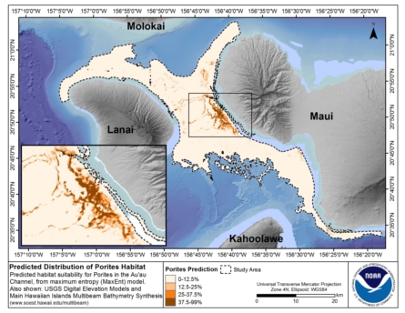
This dataset describes the predicted distribution of Porites in the Au'au Channel region in the Main Hawaiian Islands (MHI). Porites that live between 30 to 150 m in depth are considered to be mesophotic corals. Mesophotic corals are light-dependent corals adapted to the low light conditions at these moderate depths. Several physical factors potentially influence their spatial distribution, including aragonite saturation, alkalinity, pH, currents, water temperature, hard substrate availability and the availability of light at depth. Mesophotic corals and mesophotic coral ecosystems (MCEs) have increasingly been the subject of scientific study because they are being threatened by a growing number of anthropogenic stressors. They are the focus of this spatial modeling effort because the Hawaiian Islands Humpback Whale National Marine Sanctuary (HIHWNMS) is exploring the expansion of its scope beyond the protection of the North Pacific Humpback Whale (Megaptera novaeangliae) to include the conservation and management of these ecosystem components. The present study helps to address this need by examining the distribution of mesophotic corals in the Au'au Channel region.

How was the data set created?

  1. From what previous works were the data drawn?
  2. How were the data generated, processed, and modified?
  3. What similar or related data should the user be aware of?

How reliable are the data; what problems remain in the data set?


How can someone get a copy of the data set?

Are there legal restrictions on access or use of the data?
Access_Constraints: none
Use_Constraints:
These data were prepared by an agency of the United States Government. Neither the United States Government nor any agency thereof, nor any of their employees, make any warranty, expressed or implied, or assumes any legal liability or responsibility for the accuracy, completeness, or usefulness of any information, apparatus, product, or process disclosed in this report, or represents that its use would not infringe privately owned rights. Reference therein to any specific commercial product, process, or service by trade name, trademark, manufacturer, or otherwise does not necessarily constitute or imply its endorsement, recommendation, or favoring by the United States Government or any agency thereof. Any views and opinions of authors expressed herein do not necessarily state or reflect those of the United States Government or any agency thereof. No warranty, expressed or implied, is made by the U.S. Government as to the accuracy of the data and/or related materials. The act of distribution shall not constitute any such warranty, and no responsibility is assumed by the U.S. Government in the use of these data or related materials.
  1. Who distributes the data set? (Distributor 1 of 1)
    Pacific Islands Benthic Habitat Mapping Center (PIBHMC), Coral Reef Ecosystem Division (CRED), Pacific Islands Fisheries Science Center (PIFSC), National Marine Fisheries Service (NMFS), National Oceanic and Atmospheric Administration (NOAA)
    NOAA IRC
    Honolulu, HI
    USA

    808 725-5360 (voice)
    nmfs.pic.credinfo@noaa.gov
    Contact_Instructions: e-mail preferred
  2. What's the catalog number I need to order this data set? Downloadable Data
  3. What legal disclaimers am I supposed to read?
    These data are not to be used for navigational purposes. NOAA makes no warranty regarding these data, expressed or implied, nor does the fact of distribution constitute such a warranty. NOAA cannot assume liability for any damages caused by any errors or omissions in these data, nor as a result of the failure of these data to function on a particular system.
  4. How can I download or order the data?

Who wrote the metadata?

Dates:
Last modified: 05-Jun-2019
Last Reviewed: 13-Aug-2012
Metadata author:
Pacific Islands Benthic Habitat Mapping Center (PIBHMC), Coral Reef Ecosystem Division (CRED), Pacific Islands Fisheries Science Center (PIFSC), National Marine Fisheries Service (NMFS), National Oceanic and Atmospheric Administration (NOAA)
NOAA IRC
Honolulu, HI
USA

808 725-5360 (voice)
nmfs.pic.credinfo@noaa.gov
Contact_Instructions: e-mail preferred
Metadata standard:
FGDC Content Standards for Digital Geospatial Metadata (FGDC-STD-001-1998)

Generated by mp version 2.9.48 on Thu Apr 18 11:01:26 2024