CRED Map of Percent Hard Coral Cover at Tutuila Island, American Samoa

Metadata also available as - [Outline] - [Parseable text] - [XML]

Frequently anticipated questions:


What does this data set describe?

Title:
CRED Map of Percent Hard Coral Cover at Tutuila Island, American Samoa
Abstract:
This map displays optical validation observation locations and percent coverage of hard coral overlaid on bathymetry.
Supplemental_Information:
Tutuila is the largest of seven islands in American Samoa at 142.3 sq. km. Volcanic in origin, it reaches a height of 653m at Matafao Peak. Tutuila is centered at 14.30S, 169.75W, has 101.3 km of coastline and an estimated 36.2 sq. km of reef area. The port of Pago Pago is a collapsed crater and is one of the largest natural ports in the Pacific. Pago Pago contains a tuna cannery which is a hub of a large purse-seining tuna fishing fleet. The cannery outputs large amounts of nutrients as byproduct into the waters of Pago Pago harbor. The human population of Tutuila in 1990 was 45,043. It is considered a high island and contributes significant nutrient and sediment runoff to coastal waters. Tutuila's waters are protected by the 0.7 sq. km Fagatele Bay National Marine Sanctuary, as well as by the National Park of American Samoa, which covers the north-central part of the island and ~5 sq. km of coastline. Data were collected on the following cruises: Cruises CoRIS Metadata Record Names TC0201 cred_toad_tutuila_tc0201_2002 OES0402 cred_toad_tutuila_oes0402_2004 BV0801 cred_toad_tutuila_bv0801_2008 HI0802 cred_towboard_benthic_tutuila_island_2008.txt Classified data collected by the CRED TOAD camera sled are presented separately on the PIBHMC website (ftp://ftp.soest.hawaii.edu/pibhmc/website/data/amsamoa/optical/tutuila/TUT_TOAD&TOW.jpg). This map (TUT_TOAD&TOW.jpg) includes both data collected by the TOAD camera sled in 2002, 2004, and 2008, and data collected by towed-divers during 2008. The TOAD camera sled collected either video or still photographs, depending on the specific equipment set up (see separate cruise metadata for details), but all optical data has been analyzed the same way. Briefly, 5 points per photo, or per 30-second interval on video footage are classified for substrate and living cover, of which one category is 'hard-coral'. For more information on classificiation methods, refer to the PIBHMC website ftp://ftp.soest.hawaii.edu/pibhmc/website/webdocs/documentation/Optical-Proc_Overview.pdf For more information on the classification scheme, refer to the PIBHMC website ftp://ftp.soest.hawaii.edu/pibhmc/website/webdocs/documentation/Benth-Habitat-Class_Codes.htm TOAD camera sled data were classified using an older version of the current CRED-wide classification scheme that was developed in early 2011. Data was mapped across to the new scheme to allow integration with more recently analyzed data sets. In many cases there was a one to one match between categories in the old scheme versus the new scheme, but in some cases there is a minor mis-match between the old and new classification schemes. In this map 'hard coral' was originally classified as 'scleractinian coral.' 'Hard coral' includes scleractinian coral, plus a small number of non-scleractinian corals with hard skeletons (fire corals, blue coral, stylasterid hydracorals). In the previous classification scheme non-scleractinian hard corals would have been grouped with other non-scleractinian corals (e.g., black corals, soft corals). Examination of the data suggest that this difference in definition would have a negligible impact on the results as non-scleractinian corals were rarely encountered. Towed-divers have collected data around Tutuila biannually. As the surveys intend to cover the same ground, only one year of data are presented here, as the intention is to give an overview of the distribution of hard coral cover around Tutuila, rather than to present temporal variability. Towed-divers record observations of the benthos, as well as take photographs of the sea floor beneath them. Still photographs taken every 15-seconds were analyzed in Coral Point Count with Excel Extensions (CPCe) overlaying 10 stratified-random points and classifying the substrate, living cover and coral morphology (when applicable) beneath the point. The 2011 CRED-wide classification scheme, referred to above, was used. Using this scheme has enabled data from shallow reef areas, as collected by towed-divers, and deeper reef areas, as collected by the CRED TOAD camera sled, to be presented together in a unified map product. Resource Description: Map showing percent cover of hard coral classified from CRED TOAD camera sled video and photos, and towed-diver photos.
  1. How might this data set be cited?
    Pacific Islands Benthic Habitat Mapping Center (PIBHMC), Coral Reef Ecosystem Division (CRED), Pacific Islands Fisheries Science Center (PIFSC), National Marine Fisheries Service (NMFS), National Oceanic and Atmospheric Administration (NOAA), 20111201, CRED Map of Percent Hard Coral Cover at Tutuila Island, American Samoa.

    Online Links:

  2. What geographic area does the data set cover?
    West_Bounding_Coordinate: -170.92403
    East_Bounding_Coordinate: -170.49467
    North_Bounding_Coordinate: -14.21725
    South_Bounding_Coordinate: -14.37157
  3. What does it look like?
    http://www.soest.hawaii.edu/pibhmc/amsamoa_images/TUT_TOAD&TOW_445.jpg (JPEG)
    This map displays percent coverage of hard coral determined from towed-video and photo, and towed-diver photo data overlaid on bathymetry.
  4. Does the data set describe conditions during a particular time period?
    Beginning_Date: 11-Feb-2002
    Ending_Date: 25-Feb-2008
    Currentness_Reference: ground condition
  5. What is the general form of this data set?
    Geospatial_Data_Presentation_Form: digital image
  6. How does the data set represent geographic features?
    1. How are geographic features stored in the data set?
    2. What coordinate system is used to represent geographic features?
  7. How does the data set describe geographic features?

Who produced the data set?

  1. Who are the originators of the data set? (may include formal authors, digital compilers, and editors)
  2. Who also contributed to the data set?
    PIBHMC, CRED, PIFSC, NOAA, NMFS
  3. To whom should users address questions about the data?
    Pacific Islands Benthic Habitat Mapping Center (PIBHMC), Coral Reef Ecosystem Division (CRED), Pacific Islands Fisheries Science Center (PIFSC), National Marine Fisheries Service (NMFS), National Oceanic and Atmospheric Administration (NOAA)
    NOAA IRC
    Honolulu, HI

    808 725-5360 (voice)
    808 725-5429 (FAX)
    nmfs.pic.credinfo@noaa.gov
    Contact_Instructions: e-mail preferred

Why was the data set created?

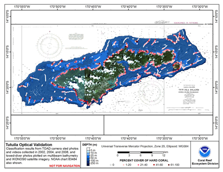
To display locations of optical validation data around Tutuila Island, American Samoa, collected by CRED TOAD (Towed Optical Assessment Device) camera sled in 2002, 2004 and 2008, and CRED towed-diver surveys in 2008. Data is symbolized by percent cover of hard coral.

How was the data set created?

  1. From what previous works were the data drawn?
  2. How were the data generated, processed, and modified?
    Date: 22-Nov-2011 (process 1 of 1)
    Classification of CRED TOAD camera sled data, and subsequent export into ArcGIS are described for each data set in the relevant cruise metadata records listed above. Towed-diver photographs were classified in Coral Point Count with Excel extensions (CPCe) software. Classified data were subsequently imported into an Oracle database and linked to geospatial data using a set of database queries that link the classified data to the geographical location, based on the photo timestamp. Classified data with latitude and longitude were then imported into ArcGIS using the Add XY data tool, and a shapefile created, so that these data could be presented along with the TOAD camera sled data.
  3. What similar or related data should the user be aware of?

How reliable are the data; what problems remain in the data set?

  1. How well have the observations been checked?
  2. How accurate are the geographic locations?
  3. How accurate are the heights or depths?
  4. Where are the gaps in the data? What is missing?
    Complete
  5. How consistent are the relationships among the observations, including topology?
    n/a

How can someone get a copy of the data set?

Are there legal restrictions on access or use of the data?
Access_Constraints: None
Use_Constraints:
Please acknowledge the NOAA Coral Reef Ecosystem Division, Pacific Islands Fisheries Science Center as the source of this information.
  1. Who distributes the data set? (Distributor 1 of 1)
    Pacific Islands Benthic Habitat Mapping Center (PIBHMC), Coral Reef Ecosystem Division (CRED), Pacific Islands Fisheries Science Center (PIFSC), National Marine Fisheries Service (NMFS), National Oceanic and Atmospheric Administration (NOAA)
    NOAA IRC
    Honolulu, HI

    808 725-5360 (voice)
    808 725-5429 (FAX)
    nmfs.pic.credinfo@noaa.gov
    Contact_Instructions: e-mail preferred
  2. What's the catalog number I need to order this data set? Downloadable Data
  3. What legal disclaimers am I supposed to read?
    These data are not to be used for navigational purposes. NOAA makes no warranty regarding these data, expressed or implied, nor does the fact of distribution constitute such a warranty. NOAA cannot assume liability for any damages caused by any errors or omissions in these data, nor as a result of the failure of these data to function on a particular system.
  4. How can I download or order the data?

Who wrote the metadata?

Dates:
Last modified: 29-Mar-2020
Last Reviewed: 16-Dec-2011
Metadata author:
Pacific Islands Benthic Habitat Mapping Center (PIBHMC), Coral Reef Ecosystem Division (CRED), Pacific Islands Fisheries Science Center (PIFSC), National Marine Fisheries Service (NMFS), National Oceanic and Atmospheric Administration (NOAA)
NOAA IRC
Honolulu, HI

808 725-5360 (voice)
808 725-5429 (FAX)
nmfs.pic.credinfo@noaa.gov
Contact_Instructions: e-mail preferred
Metadata standard:
FGDC Content Standards for Digital Geospatial Metadata (FGDC-STD-001-1998)

Generated by mp version 2.9.48 on Fri Apr 19 11:03:41 2024