Citation:
Citation_Information:
Originator:
Pacific Islands Benthic Habitat Mapping Center (PIBHMC), Coral Reef Ecosystem Division (CRED), Pacific Islands Fisheries Science Center (PIFSC), National Marine Fisheries Service (NMFS), National Oceanic and Atmospheric Administration (NOAA)
Publication_Date: 200606
Title:
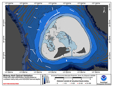
CRED Cumulative Map of Percent Scleractinian Coral Cover at Midway Atoll, 2002-04
Geospatial_Data_Presentation_Form: digital image
Online_Linkage: http://www.soest.hawaii.edu/pibhmc/pibhmc_nwhi_mid_optical.htm
Online_Linkage:
Description:
Abstract:
This map displays optical validation observation locations and percent coverage of scleractinian coral
overlaid on bathymetry.
Purpose:
To display locations of optical validation data collected and percent coverage of scleractinian coral at
Midway Atoll.
Supplemental_Information:
The Midway Islands, located at 28.2 N, 177.4W and 1.42 sq. km in area, are enclosed in the
classically shaped Midway Atoll. The underlying basalt, covered by more than 400m of fossil reef, is estimated to
be 28 million years old. (Boreholes drilled by Ladd et al. [reported in Science in 1967] reached basalt 152m below
Sand Island.) Within the reef are two islands; Sand Island was extensively modified starting in 1856 when reefs were
blasted to create a port. Midway was an important stopover on transpacific voyages, and saw regular commercial ship
and seaplane traffic. During the U.S. Navy's occupation of the atoll beginning in the 1940s, Sand Island and Eastern
Island were extensively modified to create airstrips and widen the southern shipping channel. The atoll and banks
include 223 sq. km area with of depths less than 100 m. The area is now the Midway Atoll National Wildlife Refuge
which is under jurisdiction of the U.S. Fish and Wildlife Service.
Cruises CoRIS Metadata Record Names
TC0207 cred_toad_midway_2002
OES0306 cred_toad_midway_2003
HI0401 cred_toad_midway_2004
Resource Description: Digital video images that are geo-referenced to navigation files.
Time_Period_of_Content:
Time_Period_Information:
Range_of_Dates/Times:
Beginning_Date: 2002
Ending_Date: 2004
Currentness_Reference: ground condition
Status:
Progress: Complete
Maintenance_and_Update_Frequency: As needed
Spatial_Domain:
Bounding_Coordinates:
West_Bounding_Coordinate: -177.41977
East_Bounding_Coordinate: -177.38267
North_Bounding_Coordinate: 28.28858
South_Bounding_Coordinate: 28.25578
Keywords:
Theme:
Theme_Keyword_Thesaurus: NCEI Geoportal Filter
Theme_Keyword: CoRIS_Metadata
Theme:
Theme_Keyword_Thesaurus: CRCP Project
Theme_Keyword:
Benthic Habitat Mapping and Characterization - Northwestern and Main Hawaiian Islands
Theme_Keyword: 1217
Theme:
Theme_Keyword_Thesaurus: CoRIS Theme Thesaurus
Theme_Keyword: EARTH SCIENCE > Biosphere > Aquatic Habitat > Benthic Habitat
Theme_Keyword:
EARTH SCIENCE > Biosphere > Zoology > Corals > Reef Monitoring and Assessment > Mapping
Theme_Keyword:
EARTH SCIENCE > Oceans > Coastal Processes > Coral Reefs > Coral Reef Ecology > Coral Cover
Theme_Keyword: EARTH SCIENCE > Oceans > Coastal Processes > Coral Reefs
Theme:
Theme_Keyword_Thesaurus: CoRIS Discovery Thesaurus
Theme_Keyword: Map Images > Habitats
Theme:
Theme_Keyword_Thesaurus: ISO 19115 Topic Category
Theme_Keyword: environment
Theme_Keyword: 007
Theme_Keyword: biota
Theme_Keyword: 002
Theme:
Theme_Keyword_Thesaurus: None
Theme_Keyword: Synthesis Map
Theme_Keyword: TC0207
Theme_Keyword: OES0306
Theme_Keyword: HI0401
Place:
Place_Keyword_Thesaurus: CoRIS Place Thesaurus
Place_Keyword:
OCEAN BASIN > Pacific Ocean > Central Pacific Ocean > Northwestern Hawaiian Islands > Midway Atoll (28N177W0001)
Place_Keyword:
COUNTRY/TERRITORY > United States of America > Hawaii > Honolulu > Midway Atoll (28N177W0001)
Place:
Place_Keyword_Thesaurus: None
Place_Keyword: Northwestern Hawaiian Islands
Place:
Place_Keyword_Thesaurus: CoRIS Region
Place_Keyword: NWHI
Access_Constraints: None
Use_Constraints:
Please acknowledge the NOAA Coral Reef Ecosystem Division, Pacific Islands Fisheries Science Center
as the source of this information.
Point_of_Contact:
Contact_Information:
Contact_Organization_Primary:
Contact_Organization:
Pacific Islands Benthic Habitat Mapping Center (PIBHMC), Coral Reef Ecosystem Division (CRED), Pacific Islands Fisheries Science Center (PIFSC), National Marine Fisheries Service (NMFS), National Oceanic and Atmospheric Administration (NOAA)
Contact_Person: John Rooney
Contact_Address:
Address_Type: mailing and physical address
Address: NOAA IRC
Address: NMFS/PIFSC/CRED
Address: 1845 WASP Blvd., Building 176
City: Honolulu
State_or_Province: HI
Postal_Code: 96818
Contact_Voice_Telephone: 808 725-5360
Contact_Facsimile_Telephone: 808 725-5429
Contact_Electronic_Mail_Address: nmfs.pic.credinfo@noaa.gov
Contact_Instructions: e-mail preferred
Browse_Graphic:
Browse_Graphic_File_Name:
Browse_Graphic_File_Description:
This map displays optical validation observation locations and percent coverage of scleractinian coral
overlaid on bathymetry.
Browse_Graphic_File_Type: JPEG
Data_Set_Credit:
Benthic Habitat Mapping Group, Coral Reef Ecosystem Division (CRED), Pacific Islands Fisheries Science
Center (PIFSC), NOAA
Security_Information:
Security_Classification_System: Not applicable
Security_Classification: Unclassified
Security_Handling_Description: Not applicable