Citation:
Citation_Information:
Originator:
Pacific Islands Benthic Habitat Mapping Center (PIBHMC), Coral Reef Ecosystem Division (CRED), Pacific Islands Fisheries Science Center (PIFSC), National Marine Fisheries Service (NMFS), National Oceanic and Atmospheric Administration (NOAA)
Publication_Date: 200706
Title:
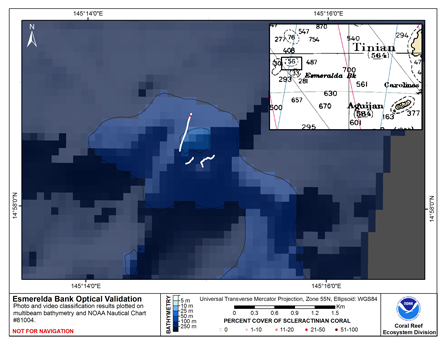
CRED Cumulative Map of Percent Scleractinian Coral Cover at Esmerelda Bank
Geospatial_Data_Presentation_Form: digital image
Online_Linkage: http://www.soest.hawaii.edu/pibhmc/pibhmc_cnmi_esm_optical.htm
Online_Linkage:
Description:
Abstract:
This map displays optical validation observation locations and percent coverage of scleractinian coral overlaid on bathymetry.
Purpose:
To display locations of optical validation data collected and percent coverage of scleractinian coral at Esmerelda Bank.
Supplemental_Information:
Esmeralda Bank is located approximately 37 km west of Tinian. There are two shallow banks plotted near Esmeralda Bank and NOAA's Nautical Chart 81004 shows four soundings less than 80 m in depth. One of these is a kidney-shaped area labeled "Active Sulphur Boil (1945)" with a depth of 30 fathoms (55 m) indicated on the chart. This bank does not exist, while the other bank and Esmeralda Bank are smaller than indicated on the chart. A multibeam survey of Esmeralda Bank was carried out during the NOAA Ring of Fire cruise in April 2004. The Bank appears to have experienced recent volcanic activity and shows signs of current hydrothermal circulation.
Cruises CoRIS Metadata Record Names
OES0307 cred_toad_emeralda_bank_oes0307_2003
Resource Description: Digital video images that are geo-referenced to navigation files.
Time_Period_of_Content:
Time_Period_Information:
Range_of_Dates/Times:
Beginning_Date: 2003
Ending_Date: 2003
Currentness_Reference: ground condition
Status:
Progress: Complete
Maintenance_and_Update_Frequency: As needed
Spatial_Domain:
Bounding_Coordinates:
West_Bounding_Coordinate: 145.24
East_Bounding_Coordinate: 145.26
North_Bounding_Coordinate: 14.98
South_Bounding_Coordinate: 14.94
Keywords:
Theme:
Theme_Keyword_Thesaurus: NCEI Geoportal Filter
Theme_Keyword: CoRIS_Metadata
Theme:
Theme_Keyword_Thesaurus: CoRIS Theme Thesaurus
Theme_Keyword: EARTH SCIENCE > Biosphere > Aquatic Habitat > Benthic Habitat
Theme_Keyword:
EARTH SCIENCE > Biosphere > Zoology > Corals > Reef monitoring and assessment > Mapping
Theme:
Theme_Keyword_Thesaurus: CoRIS Discovery Thesaurus
Theme_Keyword: Map Images > Habitats
Theme:
Theme_Keyword_Thesaurus: ISO 19115 Topic Category
Theme_Keyword: environment
Theme_Keyword: 007
Theme_Keyword: biota
Theme_Keyword: 002
Theme:
Theme_Keyword_Thesaurus: None
Theme_Keyword: Synthesis Map
Theme_Keyword: OES0307
Place:
Place_Keyword_Thesaurus: CoRIS Place Thesaurus
Place_Keyword:
OCEAN BASIN > Pacific Ocean > Western Pacific Ocean > Esmeralda Banks > Esmeralda Banks (15N145E0001)
Place_Keyword:
COUNTRY/TERRITORY > Northern Mariana Islands > Northern Mariana Islands > Esmeralda Banks (15N145E0001)
Place:
Place_Keyword_Thesaurus: None
Place_Keyword: Commonwealth of Northern Marianas Islands and Guam
Place:
Place_Keyword_Thesaurus: CoRIS Region
Place_Keyword: CNMI
Access_Constraints: None
Use_Constraints:
Please acknowledge the NOAA Coral Reef Ecosystem Division, Pacific Islands Fisheries Science Center
as the source of this information.
Point_of_Contact:
Contact_Information:
Contact_Organization_Primary:
Contact_Organization:
Pacific Islands Benthic Habitat Mapping Center (PIBHMC), Coral Reef Ecosystem Division (CRED), Pacific Islands Fisheries Science Center (PIFSC), National Marine Fisheries Service (NMFS), National Oceanic and Atmospheric Administration (NOAA)
Contact_Person: John Rooney
Contact_Address:
Address_Type: mailing and physical address
Address: NOAA IRC
Address: NMFS/PIFSC/CRED
Address: 1845 WASP Blvd., Building 176
City: Honolulu
State_or_Province: HI
Postal_Code: 96818
Contact_Voice_Telephone: 808 725-5360
Contact_Facsimile_Telephone: 808 725-5429
Contact_Electronic_Mail_Address: nmfs.pic.credinfo@noaa.gov
Contact_Instructions: e-mail preferred
Browse_Graphic:
Browse_Graphic_File_Name:
Browse_Graphic_File_Description:
This map displays optical validation observation locations and percent coverage of scleractinian coral overlaid on bathymetry.
Browse_Graphic_File_Type: JPEG
Data_Set_Credit:
Benthic Habitat Mapping Group, Coral Reef Ecosystem Division (CRED), Pacific Islands Fisheries Science
Center (PIFSC), NOAA
Security_Information:
Security_Classification_System: Not applicable
Security_Classification: Unclassified
Security_Handling_Description: Not applicable