Citation:
Citation_Information:
Originator:
Pacific Islands Benthic Habitat Mapping Center (PIBHMC), Coral Reef Ecosystem Division (CRED), Pacific Islands Fisheries Science Center (PIFSC), National Marine Fisheries Service (NMFS), National Oceanic and Atmospheric Administration (NOAA)
Publication_Date: 20111201
Title:
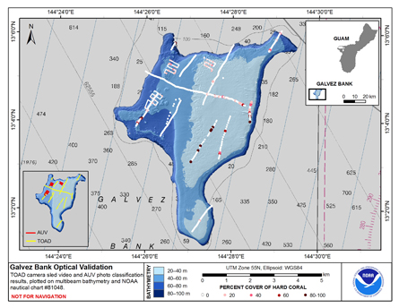
Map of Percent Scleractinian Coral Cover along towed camera sled tracks and AUV dive tracks over Galvez Bank, Territory of Guam, USA
Geospatial_Data_Presentation_Form: digital image
Online_Linkage: http://www.soest.hawaii.edu/pibhmc/
Online_Linkage:
Description:
Abstract:
This map displays optical validation observation locations and percent coverage of scleractinian coral overlaid on bathymetry. Optical data were collected
by CRED TOAD camera sled aboard the NOAA ship Oscar Elton Sette on cruises OES 0308 and SE 1002, and by the CRED-NWFSC SeaBED AUV during Oscar Elton Sette cruise SE1002.
Purpose:
To display locations of optical validation data collected and percent coverage of scleractinian coral at Galvez Bank.
Supplemental_Information:
Galvez Bank is part of the U.S. territory of Guam and located about 12 nautical miles (22 km) south-southwest of the island of Guam.
The bank actually consists of several bathymetric highs, with a minimum charted depth of 20 m. Most of the bank top is characterized by moderate relief reef, with
algae, coral patch reefs and associated reef fish communities. This map includes classified video data from all TOAD camera sled tows conducted over the bank during 20(cruise
OES0208) and 2010 (cruise SE1002), and classified photographs from selected AUV dives conducted over the bank in 2010 (cruise SE1002). During cruise SE1002 8 AUV dives
were conducted over Galvez Bank. However, as the AUV was still undergoing testing and trials, several of the dives were aborted early, and several repeated the
same route. Therefore, only photos from 3 dives have been classified for this map. These were selected due to being complete dives covering distinct routes/
More details can be found in the relevant cruise metadata:
Cruises CoRIS Metadata Record Names
OES0308 cred_toad_galvez_bank_guam_oes0308_2003.txt
SE1002 (TOAD) cred_toad_gal_se1002_2010.txt
SE1002 (AUV) cred_auv_se1002_2010.txt
Resource Description: Digital video images and still photographs that are geo-referenced to navigation files.
Time_Period_of_Content:
Time_Period_Information:
Range_of_Dates/Times:
Beginning_Date: 20030926
Ending_Date: 20111201
Currentness_Reference: ground condition
Status:
Progress: Complete
Maintenance_and_Update_Frequency: As needed
Spatial_Domain:
Bounding_Coordinates:
West_Bounding_Coordinate: 144.42
East_Bounding_Coordinate: 144.49
North_Bounding_Coordinate: 13.11
South_Bounding_Coordinate: 13.02
Keywords:
Theme:
Theme_Keyword_Thesaurus: NCEI Geoportal Filter
Theme_Keyword: CoRIS_Metadata
Theme:
Theme_Keyword_Thesaurus: CRCP Project
Theme_Keyword:
M218 Benthic Habitat Mapping and Characterization in the Pacific Islands Region
Theme_Keyword: 1217
Theme:
Theme_Keyword_Thesaurus: CoRIS Theme Thesaurus
Theme_Keyword: EARTH SCIENCE > Biosphere > Aquatic Habitat > Benthic Habitat
Theme_Keyword:
EARTH SCIENCE > Biosphere > Zoology > Corals > Reef monitoring and assessment > Mapping
Theme:
Theme_Keyword_Thesaurus: CoRIS Discovery Thesaurus
Theme_Keyword: Map Images > Habitats
Theme:
Theme_Keyword_Thesaurus: ISO 19115 Topic Category
Theme_Keyword: imageryBaseMapsEarthCover
Theme_Keyword: 010
Place:
Place_Keyword_Thesaurus: CoRIS Place Thesaurus
Place_Keyword:
OCEAN BASIN > Pacific Ocean > Western Pacific Ocean > Guam > Galvez Bank (13N144E0049)
Place_Keyword:
COUNTRY/TERRITORY > United States of America > Guam > Galvez Bank (13N144E0049)
Place:
Place_Keyword_Thesaurus: None
Place_Keyword: Commonwealth of Northern Marianas Islands and Guam
Place:
Place_Keyword_Thesaurus: CoRIS Region
Place_Keyword: Guam
Access_Constraints: None
Use_Constraints:
These data are not to be used for navigation purposes.
Please acknowledge the NOAA Pacific Islands Fisheries Science Center
(PIFSC) Coral Reef Ecosystem Division (CRED) and the Pacific Islands
Benthic Habitat Mapping Center, and the Joint Institute for Marine
and Atmospheric Research (JIMAR) and School of Ocean and Earth
Science and Technology (SOEST), University of Hawaii as the sources
of this information.
Point_of_Contact:
Contact_Information:
Contact_Organization_Primary:
Contact_Organization:
Pacific Islands Benthic Habitat Mapping Center (PIBHMC), Coral Reef Ecosystem Division (CRED), Pacific Islands Fisheries Science Center (PIFSC), National Marine Fisheries Service (NMFS), National Oceanic and Atmospheric Administration (NOAA)
Contact_Address:
Address_Type: mailing and physical address
Address: NOAA IRC
Address: NMFS/PIFSC/CRED
Address: 1845 WASP Blvd., Building 176
City: Honolulu
State_or_Province: HI
Postal_Code: 96818
Contact_Voice_Telephone: 808 725-5360
Contact_Facsimile_Telephone: 808 725-5429
Contact_Electronic_Mail_Address: nmfs.pic.credinfo@noaa.gov
Contact_Instructions: e-mail preferred
Browse_Graphic:
Browse_Graphic_File_Name:
Browse_Graphic_File_Description: n/a
Browse_Graphic_File_Type: JPEG
Data_Set_Credit:
Benthic Habitat Mapping Group, Coral Reef Ecosystem Division (CRED), Pacific Islands Fisheries Science
Center (PIFSC), NOAA
Security_Information:
Security_Classification_System: Not applicable
Security_Classification: Unclassified
Security_Handling_Description: Not applicable