Citation:
Citation_Information:
Originator:
Pacific Islands Benthic Habitat Mapping Center (PIBHMC), Coral Reef Ecosystem Division (CRED), Pacific Islands Fisheries Science Center (PIFSC), National Marine Fisheries Service (NMFS), National Oceanic and Atmospheric Administration (NOAA)
Publication_Date: 20131022
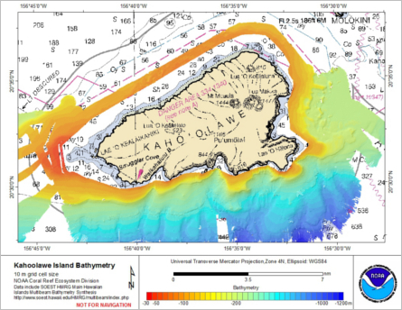
Title: Gridded bathymetry of Kahoolawe Island, Hawaii, USA
Geospatial_Data_Presentation_Form: digital data
Online_Linkage: http://www.soest.hawaii.edu/pibhmc/pibhmc_mhi_kal_bathy.htm
Online_Linkage: http://www.soest.hawaii.edu/pibhmc
Description:
Abstract:
Gridded bathymetry (10m) of Kahoolawe Island, Hawaii, USA.
The data include multibeam bathymetry from the EM120, EM122, EM710, EM1020, and EM1002 multibeam sonar collected
by the Hawai'i Undersea Research Laboratory of the University of Hawaii in depths between -30 and -1300 meters.
Data processing was done for distribution by the NOAA Coral Reef Ecosystem Division.
Purpose:
These ASCII grids were created using data gathered from multibeam soundings for documentation
and for use as a planning and reference document. Further data were collected to fill gaps in the
existing bathymetry. Refer to supplemental information for description of instrument and survey.
Supplemental_Information:
Data were collected aboard the R/V Kilo Moana, a 186' Waterplane Area Twin Hull (SWATH) vessel owned by the U.S. Navy and operated by the University
of Hawaii Marine Center. The R/V Kilo Moana's survey sensors include a Simrad EM710: 70-100 kHz swath mapping, 10-1800 m depth range
Multibeam and a Simrad EM122: 12 kHz swath mapping, 300-11,000 m depth range which measure bathymetry and
acoustic backscatter imagery, a TSS/POS/MV 320 Model which measures time, position, velocity, attitude and
heading, and a Seabird SBE 19plus CTD used to measure sound velocity profiles. Specific equipment configurations are documented:
http://www.soest.hawaii.edu/UMC/cms/kilo-moana/
http://www.rvdata.us/catalog/Kilo_Moana
http://www.soest.hawaii.edu/UMC/cms/sensor-calibration-records/
Time_Period_of_Content:
Time_Period_Information:
Range_of_Dates/Times:
Beginning_Date: 20031019
Ending_Date: 20110902
Currentness_Reference: ground condition
Status:
Progress: Complete
Maintenance_and_Update_Frequency: As needed
Spatial_Domain:
Bounding_Coordinates:
West_Bounding_Coordinate: -156.898002
East_Bounding_Coordinate: -156.450646
North_Bounding_Coordinate: 20.631343
South_Bounding_Coordinate: 20.361315
Keywords:
Theme:
Theme_Keyword_Thesaurus: NCEI Geoportal Filter
Theme_Keyword: CoRIS_Metadata
Theme:
Theme_Keyword_Thesaurus: CRCP Project
Theme_Keyword:
Benthic Habitat Mapping and Characterization in the Pacific Islands Region
Theme_Keyword: 467
Theme:
Theme_Keyword_Thesaurus: CoRIS Theme Thesaurus
Theme_Keyword:
EARTH SCIENCE > Oceans > Bathymetry/Seafloor Topography > Bathymetry
Theme:
Theme_Keyword_Thesaurus: ISO 19115 Topic Category
Theme_Keyword: elevation
Theme_Keyword: 006
Theme:
Theme_Keyword_Thesaurus: CoRIS Discovery Thesaurus
Theme_Keyword: Geographic Information > Bathymetry
Theme:
Theme_Keyword_Thesaurus: None
Theme_Keyword: Bathymetry
Theme_Keyword: Multibeam sonar
Place:
Place_Keyword_Thesaurus: None
Place_Keyword: Hawaiian Islands
Place_Keyword: Kahoolawe
Place:
Place_Keyword_Thesaurus: CoRIS Place Thesaurus
Place_Keyword:
OCEAN BASIN > Pacific Ocean > Central Pacific Ocean > Hawaiian Islands > Kahoolawe Island > Kahoolawe Island (20N156W0001)
Place_Keyword:
COUNTRY/TERRITORY > United States of America > Hawaii > Kalawao > Kahoolawe Island (20N156W0001)
Access_Constraints: None
Use_Constraints:
These data are not to be used for navigation purposes. Please acknowledge the NOAA Pacific Islands Fisheries
Science Center (PIFSC) Coral Reef Ecosystem Division (CRED) and
the Pacific Islands Benthic Habitat Mapping Center (PIBHMC), and
the Joint Institute for Marine and Atmospheric Research (JIMAR)
and School of Ocean and Earth Science and Technology (SOEST),
University of Hawaii as the sources of this information.
Point_of_Contact:
Contact_Information:
Contact_Organization_Primary:
Contact_Organization:
Pacific Islands Benthic Habitat Mapping Center (PIBHMC), Coral Reef Ecosystem Division (CRED), Pacific Islands Fisheries Science Center (PIFSC), National Marine Fisheries Service (NMFS), National Oceanic and Atmospheric Administration (NOAA)
Contact_Address:
Address_Type: mailing and physical
Address: NOAA IRC
Address: NMFS/PIFSC/CRED
Address: 1845 WASP Blvd., Building 176
City: Honolulu
State_or_Province: HI
Postal_Code: 96818
Country: USA
Contact_Voice_Telephone: 808 725-5360
Contact_Electronic_Mail_Address: nmfs.pic.credinfo@noaa.gov
Contact_Instructions: e-mail preferred
Browse_Graphic:
Browse_Graphic_File_Name:
Browse_Graphic_File_Description: Multibeam Bathymetry
Browse_Graphic_File_Type: JPEG
Data_Set_Credit: HURL,PIBHMC, CRED, PIFSC, NOAA and JIMAR
Security_Information:
Security_Classification_System: Not applicable
Security_Classification: Unclassified
Security_Handling_Description: Not applicable
Native_Data_Set_Environment:
netCDF file created using the Generic
Mapping Tools (GMT) and ArcGIS ASCII file, both created in a
LINUX environment