Citation:
Citation_Information:
Originator:
Pacific Islands Benthic Habitat Mapping Center (PIBHMC), Coral Reef Ecosystem Division (CRED), Pacific Islands Fisheries Science Center (PIFSC), National Marine Fisheries Service (NMFS), National Oceanic and Atmospheric Administration (NOAA)
Publication_Date: 20111030
Title:
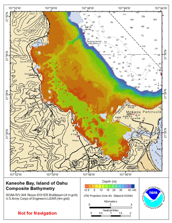
Gridded bathymetry of Kaneohe Bay, Windward Side Oahu, Main Hawaiian Islands, USA.
Geospatial_Data_Presentation_Form: digital data
Online_Linkage:
Online_Linkage: http://www.soest.hawaii.edu/pibhmc
Description:
Abstract:
4-m grid of bathymetric data of Kaneohe Bay, Windward Side Oahu, Main Hawaiian Islands, USA.
These netCDF and ASCII grids include multibeam bathymetry from the Reson 8101 multibeam sonar collected by the
National Oceanic and Atmospheric Administration (NOAA) survey launch Acoustic Habitat Investigator (AHI) in 2009
and 2010 in Kaneohe Bay, Oahu by the NOAA Coral Reef Ecosystem Division in depths between 5 and 50 meters.
The 4-m grid also contains bathymetric Light Detecting and Ranging (LiDAR) data collected by the US Army Corps
of Engineers (ACOE) in 2000 and 2007.
Purpose:
These netCDF and ASCII grids were created using data gathered from
multibeam and LiDAR depth measurements for use as a planning and reference document. The data
are also being used for benthic habitat mapping, for locating Essential Fish
Habitat, and for studying geologic features of the area. Refer to supplemental information for description of instrument and survey.
Supplemental_Information:
Time_Period_of_Content:
Time_Period_Information:
Range_of_Dates/Times:
Beginning_Date: 20000101
Ending_Date: 20101010
Currentness_Reference: ground condition
Status:
Progress: Complete
Maintenance_and_Update_Frequency: As needed
Spatial_Domain:
Bounding_Coordinates:
West_Bounding_Coordinate: -157.53
East_Bounding_Coordinate: -157.50
North_Bounding_Coordinate: 21.41
South_Bounding_Coordinate: 21.20
Keywords:
Theme:
Theme_Keyword_Thesaurus: NCEI Geoportal Filter
Theme_Keyword: CoRIS_Metadata
Theme:
Theme_Keyword_Thesaurus: CRCP Project
Theme_Keyword:
Benthic Habitat Mapping and Characterization in the Pacific Islands Region
Theme_Keyword: 467
Theme:
Theme_Keyword_Thesaurus: CoRIS Theme Thesaurus
Theme_Keyword:
EARTH SCIENCE > Oceans > Bathymetry/Seafloor Topography > Bathymetry
Theme:
Theme_Keyword_Thesaurus: ISO 19115 Topic Category
Theme_Keyword: elevation
Theme_Keyword: 006
Theme:
Theme_Keyword_Thesaurus: CoRIS Discovery Thesaurus
Theme_Keyword: Geographic Information > Bathymetry
Theme:
Theme_Keyword_Thesaurus: None
Theme_Keyword: Bathymetry
Theme_Keyword: Multibeam sonar
Place:
Place_Keyword_Thesaurus: None
Place_Keyword: Hawaiian Islands
Place_Keyword: Oahu
Place:
Place_Keyword_Thesaurus: CoRIS Region
Place_Keyword: MHI
Place:
Place_Keyword_Thesaurus: CoRIS Place Thesaurus
Place_Keyword:
OCEAN BASIN > Pacific Ocean > Central Pacific Ocean > Hawaiian Islands > Oahu Island > Oahu (21N157W0003)
Place_Keyword:
COUNTRY/TERRITORY > United States of America > Hawaii > Honolulu > Oahu (21N157W0003)
Access_Constraints: None.
Use_Constraints:
These data are NOT TO BE USED FOR NAVIGATION purposes.
Please acknowledge the PIFSC,the Joint Institute for Marine and Atmospheric
Research(JIMAR), and CRED/PIBHMC as the sources of this information.
Point_of_Contact:
Contact_Information:
Contact_Organization_Primary:
Contact_Organization:
Pacific Islands Benthic Habitat Mapping Center (PIBHMC), Coral Reef Ecosystem Division (CRED), Pacific Islands Fisheries Science Center (PIFSC), National Marine Fisheries Service (NMFS), National Oceanic and Atmospheric Administration (NOAA)
Contact_Address:
Address_Type: mailing and physical address
Address: NOAA IRC
Address: NMFS/PIFSC/CRED
Address: 1845 WASP Blvd., Building 176
City: Honolulu
State_or_Province: HI
Postal_Code: 96818
Contact_Voice_Telephone: 808 725-5360
Contact_Facsimile_Telephone: 808 725-5429
Contact_Electronic_Mail_Address: nmfs.pic.credinfo@noaa.gov
Contact_Instructions: e-mail preferred
Browse_Graphic:
Browse_Graphic_File_Name:
Browse_Graphic_File_Description: Multibeam Bathymetry
Browse_Graphic_File_Type: JPEG
Data_Set_Credit: PIBHMC, CRED, PIFSC, NOAA, JIMAR, ACOE
Security_Information:
Security_Classification_System: Not applicable
Security_Classification: Unclassified
Security_Handling_Description: Not applicable
Native_Data_Set_Environment:
netCDF file created using the Generic
Mapping Tools (GMT) and ArcGIS ASCII file, both created in a
LINUX environment