Citation:
Citation_Information:
Originator:
Pacific Islands Benthic Habitat Mapping Center (PIBHMC), Coral Reef Ecosystem Division (CRED), Pacific Islands Fisheries Science Center (PIFSC), National Marine Fisheries Service (NMFS), National Oceanic and Atmospheric Administration (NOAA)
Publication_Date: 20081010
Title:
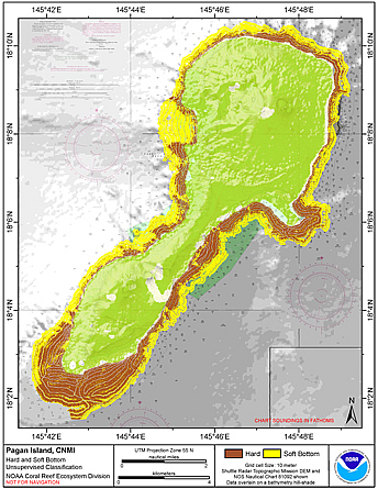
Preliminary hard and soft bottom seafloor substrate map
derived from an unsupervised classification of gridded
backscatter and bathymetry derivatives at Pagan Island, Commonwealth
of the Northern Mariana Islands (CNMI).
Geospatial_Data_Presentation_Form: digital data
Online_Linkage: http://www.soest.hawaii.edu/pibhmc/
Description:
Abstract:
Preliminary hard and soft seafloor substrate map derived
from an unsupervised classification of multibeam backscatter and
bathymety derivatives at Pagan Island, Commonwealth of the
Northern Mariana Islands (CNMI). The dataset was derived using Reson
8101 backscatter data, bathymetric variance and bathymetric rugosity.
The sonar frequency is 240 kHz for the Reson 8101 backscatter data,
which were resampled to a 5 m grid cell size prior to the classification.
Limited seafloor photographs for groundtruthing are available for Guam and
therefore no supervised classification was performed and we are unable to
visually or quantitatively evaluate the accuracy of the unsupervised
classification seafloor substrate map. However, in locations such
French Frigate Shoals, NWHI and Tutuila, American Samoa, where ground
truth data are available, the unsupervised classification method is a
robust predictor of substrate type in similar depth ranges and seafloor
environments.
Purpose:
The hard and soft seafloor map is being used to improve
sampling techniques for long-term ecosystem monitoring, to guide
future ground-truthing operations and to identify coral-rich and
species specific environments. This is a preliminary product and
the methods used to generate the map are currently being evaluated
for their accuracy.
Supplemental_Information:
Multibeam bathymetry and backscatter data were collected aboard
the R/V AHI (Acoustic Habitat Investigator). See the metadata for
that dataset served separately at www.soest.hawaii.edu/pibhmc.
The batymetric rugosity dataset is also served separately at the
same website. The bathymetric variance grids were generated for
use in the classification process and are not served separately.
See the process description portion of this document for additional
information about how the variance and unsupervised layers were derived.
Time_Period_of_Content:
Time_Period_Information:
Range_of_Dates/Times:
Beginning_Date: 20070525
Ending_Date: 20070608
Currentness_Reference: ground condition
Status:
Progress: Complete
Maintenance_and_Update_Frequency: As needed
Spatial_Domain:
Bounding_Coordinates:
West_Bounding_Coordinate: 145.667
East_Bounding_Coordinate: 145.91
North_Bounding_Coordinate: 18.19
South_Bounding_Coordinate: 18.01
Keywords:
Theme:
Theme_Keyword_Thesaurus: NCEI Geoportal Filter
Theme_Keyword: CoRIS_Metadata
Theme:
Theme_Keyword_Thesaurus: CRCP Project
Theme_Keyword:
Benthic Habitat Mapping and Characterization - Commonwealth of the Northern Mariana Islands and Guam
Theme_Keyword: 1398
Theme:
Theme_Keyword_Thesaurus: ISO 19115 Topic Category
Theme_Keyword: environment
Theme_Keyword: 007
Theme:
Theme_Keyword_Thesaurus: CoRIS Theme Thesaurus
Theme_Keyword:
EARTH SCIENCE > Oceans > Coastal Processes > Coral Reefs > Coral Reef Ecology > Habitats
Theme_Keyword: EARTH SCIENCE > Biosphere > Aquatic Habitat > Benthic Habitat
Theme_Keyword:
EARTH SCIENCE > Biosphere > Zoology > Corals > Reef Monitoring and Assessment > Mapping > Habitat Mapping
Theme_Keyword:
EARTH SCIENCE > Oceans > Bathymetry/Seafloor Topography > Soft Seafloor Substrate
Theme_Keyword:
EARTH SCIENCE > Oceans > Bathymetry/Seafloor Topography > Hard Seafloor Substrate
Theme:
Theme_Keyword_Thesaurus: CoRIS Discovery Thesaurus
Theme_Keyword: Geographic Information > Habitats
Theme:
Theme_Keyword_Thesaurus: None
Theme_Keyword: Hard bottom
Theme_Keyword: Soft bottom
Theme_Keyword: Unsupervised Classification
Theme_Keyword: Acoustic Imagery
Theme_Keyword: Multibeam Backscatter
Theme_Keyword: Backscatter
Theme_Keyword: Bathymetry
Theme_Keyword: Multibeam sonar
Theme_Keyword: Substrate
Place:
Place_Keyword_Thesaurus: None
Place_Keyword: Pagan Island
Place_Keyword: Commonwealth of the Northern Mariana Islands
Place_Keyword: United States of America
Place_Keyword: Central Pacific
Place:
Place_Keyword_Thesaurus: CoRIS Region
Place_Keyword: CNMI
Place:
Place_Keyword_Thesaurus: CoRIS Place Thesaurus
Place_Keyword:
OCEAN BASIN > Pacific Ocean > Western Pacific Ocean > Pagan Island > Pagan Island (18N145E0001)
Place_Keyword:
COUNTRY/TERRITORY > Northern Mariana Islands > Pagan > Pagan Island (18N145E0001)
Access_Constraints: None
Use_Constraints:
These data are not to be used for navigation purposes. Please acknowledge the NOAA Pacific Islands Fisheries
Science Center (PIFSC) Coral Reef Ecosystem Division (CRED) and
the Pacific Islands Benthic Habitat Mapping Center (PIBHMC), and
the Joint Institute for Marine and Atmospheric Research (JIMAR)
and School of Ocean and Earth Science and Technology (SOEST),
University of Hawaii as the sources of this information.
Point_of_Contact:
Contact_Information:
Contact_Organization_Primary:
Contact_Organization:
Pacific Islands Benthic Habitat Mapping Center (PIBHMC), Coral Reef Ecosystem Division (CRED), Pacific Islands Fisheries Science Center (PIFSC), National Marine Fisheries Service (NMFS), National Oceanic and Atmospheric Administration (NOAA)
Contact_Address:
Address_Type: mailing and physical address
Address: NOAA IRC
Address: NMFS/PIFSC/CRED
Address: 1845 WASP Blvd., Building 176
City: Honolulu
State_or_Province: HI
Postal_Code: 96818
Contact_Voice_Telephone: 808 725-5360
Contact_Facsimile_Telephone: 808 725-5429
Contact_Electronic_Mail_Address: nmfs.pic.credinfo@noaa.gov
Contact_Instructions: e-mail preferred
Browse_Graphic:
Browse_Graphic_File_Name:
Browse_Graphic_File_Description: Hard and Soft Seafloor Substrate
Browse_Graphic_File_Type: JPEG
Data_Set_Credit: PIBHMC, CRED, PIFSC, NOAA, and JIMAR
Security_Information:
Security_Classification_System: Not applicable
Security_Classification: Unclassified
Security_Handling_Description: Not applicable
Native_Data_Set_Environment:
GeoTIFF file created using ENVI 4.4 in a
Microsoft Windows environment