Integrated hard and soft bottom seafloor substrate map of Rose Atoll, American Samoa combining NOAA Pacific Island Fisheries Science Center Coral Reef Ecosystem Division hard-soft substrate maps with NOAA Center for Coastal Monitoring and Assessment Biogeography Program shallow-water benthic habitat map of American Samoa.
Metadata also available as [Questions & Answers] - [Parseable text] - [XML]
Metadata:
- Identification_Information:
-
- Citation:
-
- Citation_Information:
-
- Originator:
-
Pacific Islands Benthic Habitat Mapping Center (PIBHMC), Coral Reef Ecosystem Division (CRED), Pacific Islands Fisheries Science Center (PIFSC), National Marine Fisheries Service (NMFS), National Oceanic and Atmospheric Administration (NOAA)
- Publication_Date: 20130901
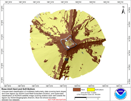
- Title:
-
Integrated hard and soft bottom seafloor substrate map of Rose Atoll, American Samoa
combining NOAA Pacific Island Fisheries Science Center Coral Reef Ecosystem Division
hard-soft substrate maps with NOAA Center for Coastal Monitoring and Assessment Biogeography
Program shallow-water benthic habitat map of American Samoa.
- Geospatial_Data_Presentation_Form: digital data
- Online_Linkage:
-
http://www.soest.hawaii.edu/pibhmc/pibhmc_amsamoa_rose_geomorph.htm
- Online_Linkage: http://www.soest.hawaii.edu/pibhmc/
- Description:
-
- Abstract:
-
Hard and soft seafloor substrate map, derived from integrating two existing map
products: hard and soft substrate maps derived from an unsupervised classification of multibeam
backscatter and bathymetry derivatives, produced by NOAA Pacific Island Fisheries Science
Center Coral Reef Ecosystem Division (CRED), and shallow-water benthic habitat map of American
Samoa, produced by NOAA Center for Coastal Monitoring and Assessment Biogeography Program.
Please refer to separate metadata and documentation for these products:
Substrate - hard bottom vs. soft bottom - 5 meter grid & 40 meter grid
http://www.soest.hawaii.edu/pibhmc/pibhmc_amsamoa_rose_geomorph.htm
Shallow-water benthic habitat map
http://ccma.nos.noaa.gov/ecosystems/coralreef/us_pac_terr/
This data is for Rose Atoll, Territory of American Samoa, USA.
- Purpose:
-
The hard and soft seafloor map previously produced by NOAA Pacific Islands
Fisheries Science Center Coral Reef Ecosystem Division is being used to improve
sampling techniques for long-term ecosystem monitoring, to guide
future ground-truthing operations and to identify coral-rich and
species specific environments. By combining this initial product with the
shallow-water benthic habitat map produced by NOAA Biogeography Branch,
a more complete hard and soft substrate map is produced, which fills in
many of the gaps in shallow water.
- Supplemental_Information:
-
Two hard and soft substrate maps were produced by NOAA Pacific Islands
Fisheries Science Center Coral Reef Ecosystem Division, one produced from
data collected by the R/V AHI Reson 8101 240 kHz multibeam sonar, and a
second using data collected by the NOAA ship Hi'ialakai Simrad em300
30 kHz multibeam sonar, covering deeper water. In both cases, the hard-
soft substrate maps were derived using backscatter data, bathymetric
variance (at 2 scales) and bathymetric rugosity. Bathymetry and backscatter
data were resampled to 5 m grid cell size prior to the classification for
shallow water product, and to 40 m grid cell size for the deeper water
product. As no seafloor photographs for groundtruthing were available
for Rose Atoll, the classification was unsupervised. However, in locations
such as French Frigate Shoals, NWHI and Tutuila, American Samoa, where
ground truth data were available, the same unsupervised classification method
has been found to be a good predictor of substrate type in similar depth
ranges and seafloor environments.
The shallow-water habitat map produced by NOAA Biogeography Branch was
derived by digitally delineating habitat boundaries from georeferenced
sonar and orthorectified IKONOS satellite imagery in ArcGIS using the
NOAA Habitat Digitizing extension. A first draft map was completed, and
areas identified for ground validation. At each ground validation point
benthic habitat was characterized by drop camera, free diving or surface
observation. A second draft map was produced incorporating the ground
validation data.
- Time_Period_of_Content:
-
- Time_Period_Information:
-
- Range_of_Dates/Times:
-
- Beginning_Date: 2002
- Ending_Date: 2010
- Currentness_Reference: ground condition
- Status:
-
- Progress: Complete
- Maintenance_and_Update_Frequency: As needed
- Spatial_Domain:
-
- Bounding_Coordinates:
-
- West_Bounding_Coordinate: -168.249
- East_Bounding_Coordinate: -168.064
- North_Bounding_Coordinate: -14.466
- South_Bounding_Coordinate: -14.633
- Keywords:
-
- Theme:
-
- Theme_Keyword_Thesaurus: NCEI Geoportal Filter
- Theme_Keyword: CoRIS_Metadata
- Theme:
-
- Theme_Keyword_Thesaurus: CRCP Project
- Theme_Keyword:
-
Benthic Habitat Mapping and Characterization in the Pacific Islands Region
- Theme_Keyword: 467
- Theme:
-
- Theme_Keyword_Thesaurus: CoRIS Theme Thesaurus
- Theme_Keyword:
-
EARTH SCIENCE > Oceans > Coastal Processes > Coral Reefs > Coral Reef Ecology > Habitats
- Theme_Keyword:
-
EARTH SCIENCE > Biosphere > Zoology > Corals > Reef Monitoring and Assessment > Mapping
- Theme_Keyword:
-
EARTH SCIENCE > Biosphere > Zoology > Corals > Reef Monitoring and Assessment > Mapping > geomorphology Mapping
- Theme_Keyword:
-
EARTH SCIENCE > Biosphere > Zoology > Corals > Reef Monitoring and Assessment > Mapping > Habitat Mapping
- Theme:
-
- Theme_Keyword_Thesaurus: CoRIS Discovery Thesaurus
- Theme_Keyword: Geographic Information > Habitats
- Theme:
-
- Theme_Keyword_Thesaurus: ISO 19115 Topic Category
- Theme_Keyword: imageryBaseMapsEarthCover
- Theme_Keyword: 010
- Place:
-
- Place_Keyword_Thesaurus: CoRIS Place Thesaurus
- Place_Keyword:
-
OCEAN BASIN > Pacific Ocean > American Samoa > Rose Atoll (14S168W0001)
- Place_Keyword:
-
COUNTRY/TERRITORY > United States of America > American Samoa > American Samoa > Rose Atoll (14S168W0001)
- Access_Constraints: None
- Use_Constraints:
-
These data are not to be used for navigation
purposes. Please acknowledge the NOAA Pacific Islands Fisheries
Science Center (PIFSC) Coral Reef Ecosystem Division (CRED) and
the Pacific Islands Benthic Habitat Mapping Center (PIBHMC), and
the Joint Institute for Marine and Atmospheric Research (JIMAR)
and School of Ocean and Earth Science and Technology (SOEST),
University of Hawaii as the sources of this information.
- Point_of_Contact:
-
- Contact_Information:
-
- Contact_Organization_Primary:
-
- Contact_Organization:
-
Pacific Islands Benthic Habitat Mapping Center (PIBHMC), Coral Reef Ecosystem Division (CRED), Pacific Islands Fisheries Science Center (PIFSC), National Marine Fisheries Service (NMFS), National Oceanic and Atmospheric Administration (NOAA)
- Contact_Address:
-
- Address_Type: mailing and physical
- Address: NOAA IRC
- Address: NMFS/PIFSC/CRED
- Address: 1845 WASP Blvd., Building 176
- City: Honolulu
- State_or_Province: HI
- Postal_Code: 96818
- Country: USA
- Contact_Voice_Telephone: 808 725-5360
- Contact_Electronic_Mail_Address: nmfs.pic.credinfo@noaa.gov
- Contact_Instructions: e-mail preferred
- Browse_Graphic:
-
- Browse_Graphic_File_Name:
-
http://www.soest.hawaii.edu/pibhmc/amsamoa_images/ros_5m_hs_int_445.png
- Browse_Graphic_File_Description: Hard and Soft Seafloor Substrate
- Browse_Graphic_File_Type: JPEG, PDF
- Data_Set_Credit:
-
PIBHMC, CRED, PIFSC, NOAA, JIMAR, NOS, NCCOS, CCMA, Biogeography Program
- Security_Information:
-
- Security_Classification_System: Not applicable
- Security_Classification: Unclassified
- Security_Handling_Description: Not applicable
- Data_Quality_Information:
-
- Attribute_Accuracy:
-
- Attribute_Accuracy_Report:
-
Data are collected for resource
management and research purposes and are tested for internal
consistency; however, no effort is made to compare these data to
external references or to other published data.
- Logical_Consistency_Report:
-
These data are believed to be logically
consistent though no tests were performed
- Completeness_Report: Complete
- Positional_Accuracy:
-
- Horizontal_Positional_Accuracy:
-
- Horizontal_Positional_Accuracy_Report:
-
Horizontal positioning system: GPS (SPS)
Horizontal position accuracy: 25 meters
- Lineage:
-
- Process_Step:
-
- Process_Description:
-
The process description to produce the CRED hard-soft substrate map
can be found in the metadata for that product:
Substrate - hard bottom vs. soft bottom - 5 meter grid
ftp://ftp.soest.hawaii.edu/pibhmc/website/data/amsamoa/benthichabitatlayers/Rose_5m_hardsoft.txt
Substrate - hard bottom vs. soft bottom - 40 meter grid
ftp://ftp.soest.hawaii.edu/pibhmc/website/data/amsamoa/benthichabitatlayers/Rose_40m_hardsoft.txt
The process description to produce the Biogeography Program
shallow-water benthic habitat map can be found in the metadata
for that product:
https://products.coastalscience.noaa.gov/collections/benthic/e99us_pac/
To combine the two maps, several steps had to be first taken
with the Biogeography Program shallow-water benthic habitat map.
First polygons were deleted that were not required for this product;
the polygons where the Major Reef Structure (M_STRUCT) was either
'Unknown' or 'Other Delineations' were deleted, leaving only polygons
where M_STRUCT was 'Coral Reef and Hardbottom' or 'Unconsolidated Sediment.'
Polygons covering the lagoon were also deleted as these were covered by the 5-m
hard bottom vs. soft bottom product.
The polygon shapefile was then converted into an ArcGIS Raster, using the
ArcGIS tool, 'Polygon To Raster.'The raster values were checked to ensure
that the same value was equivalent to hard substrate as in the
CRED hard-soft map, where 'Coral Reef and Hardbottom' was classed as 'hard'
and 'Unconsolidated Sediment' was classed as 'soft'.
To combine the three maps, the raster layers were
mosaiced, using the ArcGIS tool, 'Mosaic To New Raster.'
- Process_Date: 20130501
- Spatial_Data_Organization_Information:
-
- Direct_Spatial_Reference_Method: Raster
- Raster_Object_Information:
-
- Raster_Object_Type: Grid Cell
- Row_Count: 540
- Column_Count: 447
- Vertical_Count: 1
- Spatial_Reference_Information:
-
- Horizontal_Coordinate_System_Definition:
-
- Planar:
-
- Grid_Coordinate_System:
-
- Grid_Coordinate_System_Name: Universal Transverse Mercator
- Universal_Transverse_Mercator:
-
- UTM_Zone_Number: -2
- Transverse_Mercator:
-
- Scale_Factor_at_Central_Meridian: 0.9996
- Longitude_of_Central_Meridian: -171
- Latitude_of_Projection_Origin: 0
- False_Easting: 500000
- False_Northing: 10000000
- Planar_Coordinate_Information:
-
- Planar_Coordinate_Encoding_Method: row and column
- Coordinate_Representation:
-
- Abscissa_Resolution: 5
- Ordinate_Resolution: 5
- Planar_Distance_Units: meters
- Geodetic_Model:
-
- Horizontal_Datum_Name: D_WGS_1984
- Ellipsoid_Name: WGS_1984
- Semi-major_Axis: 6378137.000000
- Denominator_of_Flattening_Ratio: 298.257224
- Vertical_Coordinate_System_Definition:
-
- Depth_System_Definition:
-
- Depth_Datum_Name: mean lower low water
- Depth_Resolution: 0.01
- Depth_Distance_Units: meters
- Depth_Encoding_Method: Attribute values
- Entity_and_Attribute_Information:
-
- Overview_Description:
-
- Entity_and_Attribute_Overview: none
- Entity_and_Attribute_Detail_Citation: none
- Distribution_Information:
-
- Distributor:
-
- Contact_Information:
-
- Contact_Organization_Primary:
-
- Contact_Organization:
-
Pacific Islands Benthic Habitat Mapping Center (PIBHMC), Coral Reef Ecosystem Division (CRED), Pacific Islands Fisheries Science Center (PIFSC), National Marine Fisheries Service (NMFS), National Oceanic and Atmospheric Administration (NOAA)
- Contact_Address:
-
- Address_Type: mailing and physical
- Address: NOAA IRC
- Address: NMFS/PIFSC/CRED
- Address: 1845 WASP Blvd., Building 176
- City: Honolulu
- State_or_Province: HI
- Postal_Code: 96818
- Country: USA
- Contact_Voice_Telephone: 808 725-5360
- Contact_Electronic_Mail_Address: nmfs.pic.credinfo@noaa.gov
- Contact_Instructions: e-mail preferred
- Resource_Description: Downloadable Data
- Distribution_Liability:
-
These data are not to be used for navigational purposes.
NOAA makes no warranty regarding these data, expressed or
implied, nor does the fact of distribution constitute such a
warranty. NOAA cannot assume liability for any damages caused by
any errors or omissions in these data, nor as a result of the
failure of these data to function on a particular system.
- Standard_Order_Process:
-
- Digital_Form:
-
- Digital_Transfer_Information:
-
- Format_Name: Arc ASCII
- Format_Information_Content:
-
Arc ASCII can be converted to Arc Raster
using ArcToolbox Conversion Tools (ASCIItoRaster).
- Digital_Transfer_Option:
-
- Online_Option:
-
- Computer_Contact_Information:
-
- Network_Address:
-
- Network_Resource_Name:
-
ftp://ftp.soest.hawaii.edu/pibhmc/website/data/amsamoa/benthichabitatlayers/ros_5m_hs_int.zip
- Fees: None
- Metadata_Reference_Information:
-
- Metadata_Date: 20220504
- Metadata_Contact:
-
- Contact_Information:
-
- Contact_Organization_Primary:
-
- Contact_Organization:
-
Pacific Islands Benthic Habitat Mapping Center (PIBHMC), Coral Reef Ecosystem Division (CRED), Pacific Islands Fisheries Science Center (PIFSC), National Marine Fisheries Service (NMFS), National Oceanic and Atmospheric Administration (NOAA)
- Contact_Address:
-
- Address_Type: mailing and physical
- Address: NOAA IRC
- Address: NMFS/PIFSC/CRED
- Address: 1845 WASP Blvd., Building 176
- City: Honolulu
- State_or_Province: HI
- Postal_Code: 96818
- Country: USA
- Contact_Voice_Telephone: 808 725-5360
- Contact_Electronic_Mail_Address: nmfs.pic.credinfo@noaa.gov
- Contact_Instructions: e-mail preferred
- Metadata_Standard_Name: FGDC Content Standards for Digital Geospatial Metadata
- Metadata_Standard_Version: FGDC-STD-001-1998
- Metadata_Time_Convention: universal time
- Metadata_Access_Constraints: None
- Metadata_Use_Constraints: None
- CoRIS:
-
- CoRIS_Metadata_Link:
-
https://www.coris.noaa.gov/metadata/records/html/ros_5m_hs_int.html
- CoRIS_Tracking_ID: 6748
Generated by mp version 2.9.48 on Wed Apr 24 10:41:49 2024