Citation:
Citation_Information:
Originator:
Pacific Islands Benthic Habitat Mapping Center (PIBHMC), Coral Reef Ecosystem Division (CRED), Pacific Islands Fisheries Science Center (PIFSC), National Marine Fisheries Service (NMFS), National Oceanic and Atmospheric Administration (NOAA)
Publication_Date: 20130201
Title:
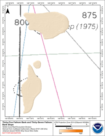
Rugosity grid derived from gridded bathymetry of Thirty-Five Fathom Bank and Thirty-Seven Fathom Bank, Commonwealth of the
Northern Marianas.
Geospatial_Data_Presentation_Form: Raster digital data
Online_Linkage:
Online_Linkage: https://www.soest.hawaii.edu/pibhmc/cms/
Description:
Abstract:
Rugosity is derived from gridded (5 m cell size) multibeam
bathymetry, aboard NOAA Ship Oscar Elton Sette.
Cell values reflect the (surface area) / (planimetric area)
ratio for the area contained within that cell's boundaries. They
provide indices of topographic roughness & convolutedness. This data set
is for Thirty-Five Fathom Bank, and Thirty-Seven Fathom Bank, Commonwealth of the Northern Marianas.
Purpose:
The data were derived in support of NOAA Coral Reef Conservation
Program goals. Goal 1 is to map all U.S. Coral Reef Ecosystems.
This data set specifically addresses Objective 1 and 4: to develop
high-resolution benthic maps and to characterize priority deep
water reefs and associated habitats. This derivative of bathymetry
provides a GIS layer that may be used for benthic and essential fish
habitat characterization, and for the study of geologic features.
By combining the dataset with bathymetry, backscatter, other
derivatives, and in situ data, they collectively compose benthic
habitat maps which are designed to be used to understand and predict
moderate depth (~20m to 150m) benthic habitats for different
organisms that inhabit coral reef ecosystems.
Supplemental_Information:
Gridded bathymetry data were collected aboard the NOAA Ship Oscar Elton Sette, a 224’ (68 m) United States
National Oceanographic and Atmospheric Administration research ship. The NOAA Ship
Sette's survey sensors included a 240-kHz pole-mounted Reson 8101ER sonar, which provides
bathymetry and imagery data, a TSS/Applanix POS/MV Model 320, which measures position,velocity, attitude and
heading, and a Seabird SBE19 CTD used to measure sound velocity profiles.
The metadata for the bathymetry is documented in this product metadata:
ftp://ftp.soest.hawaii.edu/pibhmc/website/data/cnmi-guam/bathymetry/35fth_37fth_Bank_5m_bathy.txt
Specific equipment configurations are documented in metadata from cruise
SE1002. These metadata can be accessed at:
https://www.soest.hawaii.edu/pibhmc/cms/cruise-catalog/
Spatial_Data_Organization_Information
Direct_Spatial_Reference_Method Raster
Raster_Object_Information tff_5m_rug
Raster_Object_Type Grid Cell
Row_Count 1432
Column_Count 2397
Vertical_Count 1
Spatial_Data_Organization_Information
Direct_Spatial_Reference_Method Raster
Raster_Object_Information tsf_5m_rug
Raster_Object_Type Grid Cell
Row_Count 2769
Column_Count 1078
Vertical_Count 1
Time_Period_of_Content:
Time_Period_Information:
Range_of_Dates/Times:
Beginning_Date: 20100211
Ending_Date: 20100314
Currentness_Reference: ground condition
Status:
Progress: Complete
Maintenance_and_Update_Frequency: As needed
Spatial_Domain:
Bounding_Coordinates:
West_Bounding_Coordinate: 146.003
East_Bounding_Coordinate: 146.120
North_Bounding_Coordinate: 16.471
South_Bounding_Coordinate: 16.234
Keywords:
Theme:
Theme_Keyword_Thesaurus: NCEI Geoportal Filter
Theme_Keyword: CoRIS_Metadata
Theme:
Theme_Keyword_Thesaurus: CRCP Project
Theme_Keyword:
Benthic Habitat Mapping and Characterization in the Pacific Islands Region
Theme_Keyword: 467
Theme:
Theme_Keyword_Thesaurus: CoRIS Theme Thesaurus
Theme_Keyword:
EARTH SCIENCE > Biosphere > Aquatic Habitat > Reef Habitat > Description
Theme_Keyword:
EARTH SCIENCE > Oceans > Bathymetry/Seafloor Topography > Bathymetry
Theme_Keyword:
EARTH SCIENCE > Oceans > Bathymetry/Seafloor Topography > Rugosity
Theme:
Theme_Keyword_Thesaurus: CoRIS Discovery Thesaurus
Theme_Keyword: Geographic Information > Habitats
Theme:
Theme_Keyword_Thesaurus: ISO 19115 Topic Category
Theme_Keyword: imageryBaseMapsEarthCover
Theme_Keyword: 010
Place:
Place_Keyword_Thesaurus: None
Place_Keyword: Thirty-Five Fathom Bank
Place_Keyword: Thirty-Seven Fathom Bank
Place_Keyword: 35 fthm Bank
Place_Keyword: 37 fthm Bank
Place_Keyword: Commonwealth of the Northern Marianas
Place_Keyword: United States of America
Place:
Place_Keyword_Thesaurus: CoRIS Place Thesaurus
Place_Keyword:
OCEAN BASIN > Pacific Ocean > Western Pacific Ocean > Mariana Archipelago > Northern Mariana Islands ( CNMI ) (18N146E0000)
Place_Keyword:
COUNTRY/TERRITORY > Northern Mariana Islands > Northern Mariana Islands > Northern Mariana Islands ( CNMI ) (18N146E0000)
Place:
Place_Keyword_Thesaurus: CoRIS Region
Place_Keyword: CNMI
Access_Constraints: None
Use_Constraints:
These data are not to be used for navigation purposes. Please acknowledge the NOAA Pacific Islands Fisheries
Science Center (PIFSC) Coral Reef Ecosystem Division (CRED) and
the Pacific Islands Benthic Habitat Mapping Center, and the Joint
Institute for Marine and Atmospheric Research (JIMAR) and School
of Ocean and Earth Science and Technology (SOEST), University of
Hawaii as the sources of this information.
Point_of_Contact:
Contact_Information:
Contact_Organization_Primary:
Contact_Organization:
Pacific Islands Benthic Habitat Mapping Center (PIBHMC), Coral Reef Ecosystem Division (CRED), Pacific Islands Fisheries Science Center (PIFSC), National Marine Fisheries Service (NMFS), National Oceanic and Atmospheric Administration (NOAA)
Contact_Address:
Address_Type: mailing and physical address
Address: NOAA IRC
Address: NMFS/PIFSC/CRED
Address: 1845 WASP Blvd., Building 176
City: Honolulu
State_or_Province: HI
Postal_Code: 96818
Country: USA
Contact_Voice_Telephone: 808 725-5360
Contact_Electronic_Mail_Address: nmfs.pic.credinfo@noaa.gov
Contact_Instructions: e-mail preferred
Browse_Graphic:
Browse_Graphic_File_Name:
Browse_Graphic_File_Description: Gridded Bathymetry Derivative
Browse_Graphic_File_Type: JPEG
Data_Set_Credit: NOAA PIFS, CRED, PIBHMC, JIMAR, and SOEST
Security_Information:
Security_Classification_System: Not applicable
Security_Classification: Unclassified
Security_Handling_Description: Not applicable
Native_Data_Set_Environment: ArcGIS ASCII file