Online Links:
PIBHMC, CRED, PIFSC, NOAA and JIMAR
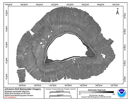
The netCDF grids of backscatter imagery were created using data gathered from multibeam soundings for use as a planning and reference document. The data are also being used for benthic habitat mapping, for locating Essential Fish Habitat, and for studying geologic features of the area. Refer to supplemental information for description of instrument and survey.
Are there legal restrictions on access or use of the data?
- Access_Constraints: None
- Use_Constraints:
- These data are not to be used for navigation purposes. Please acknowledge NOAA and the Joint Institute for Marine and Atmospheric Research (JIMAR) University of Hawaii as the sources of this information.
These data are not to be used for navigational purposes. NOAA makes no warranty regarding these data, expressed or implied, nor does the fact of distribution constitute such a warranty. NOAA cannot assume liability for any damages caused by any errors or omissions in these data, nor as a result of the failure of these data to function on a particular system.
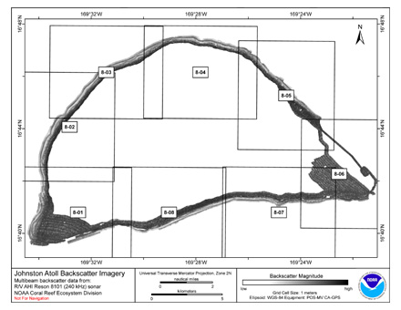
| Data format: | Binary netCDF Grid: This file is formatted as a 2-D binary netCDF grid file. This is the default grid file format used by GMT (Generic Mapping Tools). The file was created by the HMRG sofware program bsovl. More information about netCDF files can be found at at http://www.soest.hawaii.edu/gmt/ and http://www.unidata.ucar.edu/software/netcdf/. List of Johnston Island Reson 8101 backscatter netCDF files and bounding coordinates: johnston-8101-8-01.01.00m.ss.grd W/E/S/N -169.58/-169.508/16.6495/16.709 johnston-8101-8-02.01.00m.ss.grd W/E/S/N -169.58/-169.518/16.6996/16.769 johnston-8101-8-03.01.00m.ss.grd W/E/S/N -169.56/-169.488/16.7395/16.799 johnston-8101-8-04.01.00m.ss.grd W/E/S/N -169.5/-169.428/16.7395/16.799 johnston-8101-8-05.01.00m.ss.grd W/E/S/N -169.44/-169.378/16.7195/16.789 johnston-8101-8-06.01.00m.ss.grd W/E/S/N -169.4/-169.338/16.6695/16.7394 johnston-8101-8-07.01.00m.ss.grd W/E/S/N -169.45/-169.378/16.6495/16.709 johnston-8101-8-08.01.00m.ss.grd W/E/S/N -169.52/-169.448/16.6495/16.709 in format netCDF, .grd |
|---|---|
| Network links: |
http://www.soest.hawaii.edu/pibhmc/cms/data-by-location/pacific-remote-island-area/johnston-atoll/johnston-atoll-backscatter/ |