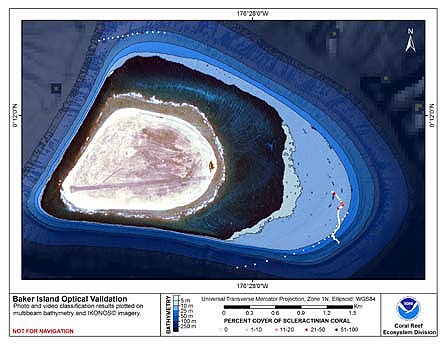
CRED Cumulative Map of Percent Scleractinian Coral Cover at Baker Island, 2002-2004
This map displays optical validation observation locations and percent coverage of scleractinian coral overlaid on bathymetry.
Baker, a low-lying 1.64 sq.km. island in the Pacific Remote Island Area (PRIA), is the second northernmost of the Phoenix Islands. Centered at 00.13'N,176.28'W, it is within one degree latitude of the equator. It lies within an arid zone of the tropical Pacific, with insufficient groundwater and rainfall to support continuous human habitation. Although Baker was unhabited at the time of its discovery by Western sailors, Polynesians probably visited it periodically over many centuries to harvest fish and wildlife. The lack of human habitation allowed Baker's coral reefs to remain completely pristine until the early 20th century. Even today it lies beyond the influence of urban centers, associated pollutants and major shipping lanes. In 1857, Baker was claimed by the U.S. under the Guano Act. A short-lived colonization attempt was made between 1935 and World War II, but was abandoned thereafter. A military airstrip was constructed on the island during the war. A no-take island and marine protected area National Wildlife Refuge administered by the U.S. Fish and Wildlife Service, Baker is under the joint jurisdiction of the Departments of Interior and Commerce. Ocean currents transport and distribute larvae among and between different atolls and islands, and particularly in the Pacific equatorial region, define sea surface temperatures (SSTs) and available nutrient regimes. The North Equatorial Current (NEC), Equatorial Counter Current (ECC), Equatorial Undercurrent or Cromwell Current (EUC), and South Equatorial Current (SEC) provide the mechanism by which many species are distributed among the PRIAs, nearby central Pacific islands, the main Hawaiian Islands (MHI), as well as other distant regions.
Cruises CoRIS Metadata Record Names
TC0201 cred_toad_baker_2002
OES0401 cred_toad_baker_2004
Resource Description: Digital video images that are geo-referenced to navigation files.