NOAA Coral Reef Watch Version 3.1 Daily Global 5km Satellite Coral Bleaching Heat Stress Monitoring Product Suite

Metadata also available as - [Outline] - [Parseable text] - [XML]

Frequently anticipated questions:


What does this data set describe?

Title:
NOAA Coral Reef Watch Version 3.1 Daily Global 5km Satellite Coral Bleaching Heat Stress Monitoring Product Suite
Abstract:
The NOAA Coral Reef Watch (CRW) daily global 5km (0.05 degree spatial resolution exactly) satellite coral bleaching heat stress monitoring product suite presented here is Version 3.1. Released August 1, 2018, the suite spans January 1, 1985 to the present and is based on CRW's CoralTemp Version 1.0 (https://coralreefwatch.noaa.gov/satellite/coraltemp.php). (CoralTemp Version 1.0 is a satellite-derived daily global 5km sea surface temperature [SST] analysis dating to 1985, developed from a combination of NOAA/National Environmental Satellite, Data, and Information Service’s [NESDIS’] operational daily global 5km Geostationary-Polar-orbiting [Geo-Polar] Blended Night-only SST Analysis; NESDIS’ 2002-2016 reprocessed daily global 5km Geo-Polar Blended Night-only SST Analysis; and the United Kingdom Met Office’s 1985-2002 daily global 5km night-only SST reanalysis on the Operational SST and Sea Ice Analysis [OSTIA].) A new climatology, introduced in CRW's Version 3.0 products and derived from CRW's CoralTemp Version 1.0 SST dataset, is maintained in the Version 3.1 5km product suite. The Version 3.1 products were developed based on user requests for a longer time series of comparable CRW 5km products, and to address errors identified in the operational daily global 5km Geo-Polar Blended Night-only SST Analysis for some coral reef regions during 2013-2016. Current daily global 5km products include SST, SST Anomaly, Coral Bleaching HotSpot, Degree Heating Week, a single-day Bleaching Alert Area, a 7-day maximum Bleaching Alert Area, and a 7-day SST Trend. CRW also developed year-to-date, monthly, and annual composites (maximum and, if applicable, mean and minimum) of the Version 3.1 5km products. CRW’s other well-used, daily 5km products, including CRW’s Regional Virtual Stations/Bleaching Heat Stress Gauges (https://coralreefwatch.noaa.gov/vs/index.php) and a free, automated Bleaching Alert Email System (https://coralreefwatch-satops.noaa.gov/), will be updated shortly to utilize the Version 3.1 global products. The next-generation 5km products significantly advance CRW's capability for near real-time satellite coral bleaching heat stress monitoring, as compared with CRW’s heritage twice-weekly 50km global coral bleaching product suite. The 5km products now comprise the core of CRW's Decision Support System (DSS) for coral reef ecosystem management, providing service at or near reef-scales, allowing direct monitoring of 95% of global coral reefs and significantly reducing data gaps caused by cloud cover. They are expected to undergo continuous improvements. For more information on the evolution of CRW’s daily global 5km satellite coral bleaching heat stress product suites, visit https://coralreefwatch.noaa.gov/product/5km/history_5km_products.php.
  1. How might this data set be cited?
    NOAA Coral Reef Watch program, 20180813, NOAA Coral Reef Watch Version 3.1 Daily Global 5km Satellite Coral Bleaching Heat Stress Monitoring Product Suite: NOAA Coral Reef Watch program, College Park, Maryland, USA.

    Online Links:

  2. What geographic area does the data set cover?
    West_Bounding_Coordinate: -180.0
    East_Bounding_Coordinate: 180.0
    North_Bounding_Coordinate: 90.0
    South_Bounding_Coordinate: -90.0
  3. What does it look like?
    https://coralreefwatch.noaa.gov/data/5km/v3.1/current/daily/gif/cur_coraltemp5km_max_r07d_baa_large.gif (GIF)
    This is the most recent global image of the daily 5km satellite Bleaching Alert Area (7-day maximum) product.
    https://coralreefwatch.noaa.gov/data/5km/v3.1/current/daily/gif/cur_coraltemp5km_hs_large.gif (GIF)
    This is the most recent global image of the daily 5km Coral Bleaching HotSpot productt.
    https://coralreefwatch.noaa.gov/data/5km/v3.1/current/daily/gif/cur_coraltemp5km_dhw_large.gif (GIF)
    This is the most recent global image of the daily 5km satellite coral bleaching DHW product.
    https://coralreefwatch.noaa.gov/data/5km/v3.1/current/daily/gif/cur_coraltemp5km_sst_large.gif (GIF)
    This is the most recent global image of the daily 5km SST product.
    https://coralreefwatch.noaa.gov/data/5km/v3.1/current/daily/gif/cur_coraltemp5km_ssta_large.gif (GIF)
    This is the most recent global image of the daily 5km SST Anomaly product.
    https://coralreefwatch.noaa.gov/data/5km/v3.1/current/daily/gif/cur_coraltemp5km_ssttrend_007d_large.gif (GIF)
    This is the most recent global image of the daily 5km 7-day SST Trend product.
  4. Does the data set describe conditions during a particular time period?
    Beginning_Date: 01-Jan-1985
    Ending_Date: Present
    Currentness_Reference: Ground Condition
  5. What is the general form of this data set?
    Geospatial_Data_Presentation_Form: web page, data, image
  6. How does the data set represent geographic features?
    1. How are geographic features stored in the data set?
      This is a Raster data set. It contains the following raster data types:
      • Dimensions 3600 x 7200, type Grid Cell
    2. What coordinate system is used to represent geographic features?
      Horizontal positions are specified in geographic coordinates, that is, latitude and longitude. Latitudes are given to the nearest 0.05. Longitudes are given to the nearest 0.05. Latitude and longitude values are specified in Decimal degrees.
  7. How does the data set describe geographic features?
    Grid Intersection
    There are 7200 grid intersections in each row (at a pre-defined latitude) and 3600 grid intersections in each column (at a pre-defined longitude). Each grid is 0.05 degrees latitude by 0.05 degrees longitude in size, centered at latitudes from 89.975S northward to 89.975N and at longitudes from 179.975W eastward to 179.975E. (Source: https://coralreefwatch.noaa.gov/product/5km/index.php)
    NOAA Coral Reef Watch Daily Global 5km Satellite Coral Bleaching Heat Stress Monitoring Product data in netCDF format
    These are the 5km satellite coral bleaching heat stress monitoring data (Source: https://coralreefwatch.noaa.gov/product/5km/index.php)
    Range of values
    Minimum:variable dependent
    Maximum:variable dependent
    Units:variable dependent
    NOAA Coral Reef Watch Daily Global 5km Satellite Coral Bleaching Heat Stress Monitoring Product images in GIF format
    These are the image displays of CRW's 5km satellite coral bleaching heat stress monitoring data (Source: https://coralreefwatch.noaa.gov/product/5km/index.php)
    Range of values
    Minimum:0
    Maximum:255
    Units:Index color values

Who produced the data set?

  1. Who are the originators of the data set? (may include formal authors, digital compilers, and editors)
  2. Who also contributed to the data set?
  3. To whom should users address questions about the data?
    NOAA Coral Reef Watch program
    Attn: NOAA Coral Reef Watch Coordinator
    NOAA, E/RA3, Room 3222, 5830 University Research Court
    College Park, Maryland
    USA

    301-683-3320 (voice)
    301-683-3301 (FAX)
    coralreefwatch@noaa.gov

Why was the data set created?

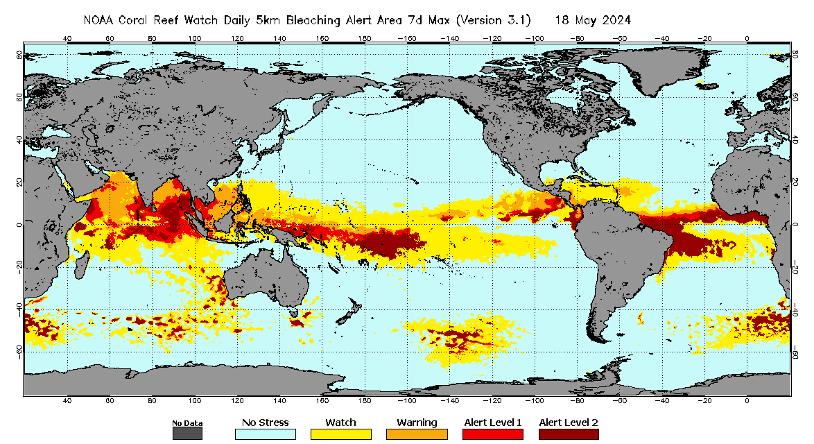
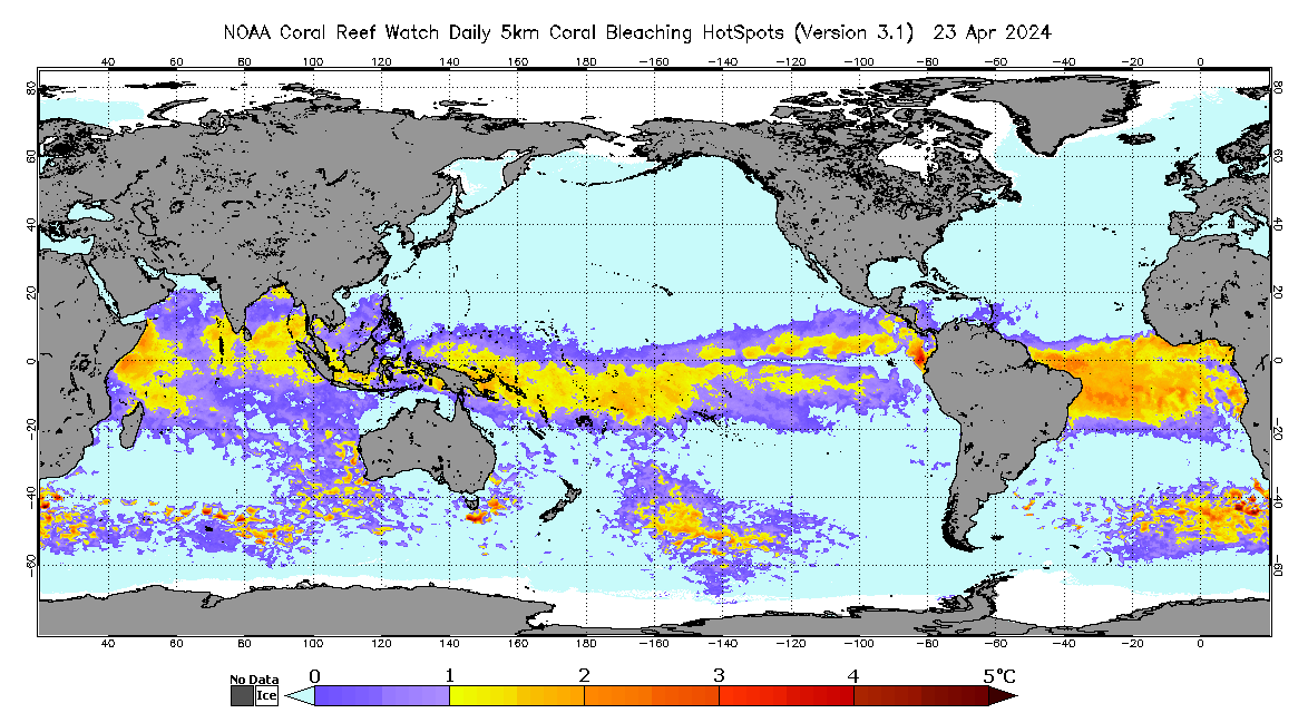
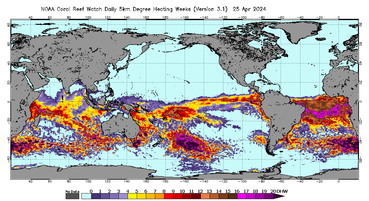
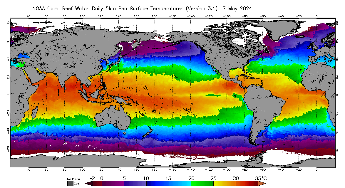
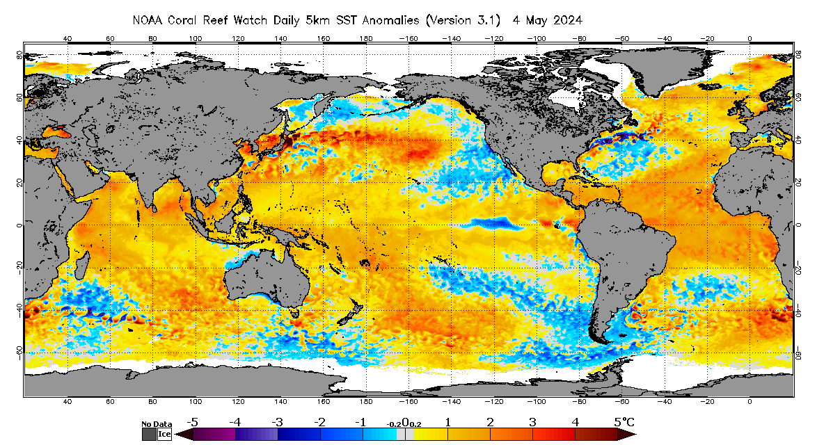
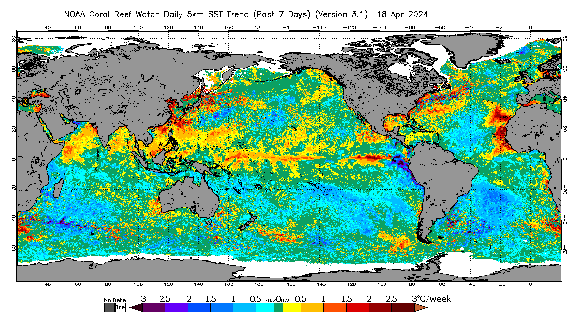
Thermally induced mass coral bleaching has become a serious threat to coral reefs worldwide and is most often caused by anomalously elevated SSTs. In recent decades, coral reef ecosystems have been declining at alarming rates worldwide, with thermally induced coral bleaching being one of the most significant contributors to this increased deterioration. The need for improved understanding, monitoring, and prediction of coral bleaching is imperative. Satellite remote sensing, with its capability of providing synoptic views of the global oceans in near-real-time and its ability to monitor remote reef areas, has been an essential tool for coral reef managers, researchers, and other stakeholders worldwide. The NOAA CRW mission is to utilize remote sensing, modeled, and in-situ tools for near real-time and long-term monitoring, modeling and reporting of physical environmental conditions of coral reef ecosystems. CRW has been producing satellite SST-based global (and regional) products to monitor thermal conditions conducive to coral bleaching and assess the severity of coral bleaching since 1997. This effort was carried out originally using CRW’s twice-weekly 50km global coral bleaching product suite. It has been enhanced with CRW's next-generation, daily global 5km product suite, available since 2012 and currently in Version 3.1, as documented in this metadata file. The next-generation 5km products significantly advance CRW's capability for near real-time satellite coral bleaching heat stress monitoring, as compared with CRW’s heritage twice-weekly 50km global coral bleaching product suite. This Version 3.1 suite, in particular, was developed based on user requests for a longer time series of comparable CRW 5km products, and to address errors identified in the operational daily global 5km Geo-Polar Blended Night-only SST Analysis for some coral reef regions during 2013-2016. CRW’s satellite products have been used extensively by coral reef ecosystem managers, scientists, and other stakeholders to guide their management practices, reef conservation and protection initiatives, public outreach campaigns leading up to and during major bleaching events, in-situ surveys, research efforts, and more. With significantly higher spatial and temporal resolutions in the 5km products, CRW can provide service at or close to the scale of coral reefs, allowing direct monitoring of 95% of global coral reefs and significantly reducing data gaps caused by cloud cover.

How was the data set created?

  1. From what previous works were the data drawn?
    NOAA CRW Daily Global 5km Bleaching Alert Area (source 1 of 4)
    NOAA/NESDIS Coral Reef Watch program, 20180801, NOAA CRW Version 3.1 Daily Global 5km Satellite Coral Bleaching Alert Area: NOAA Coral Reef Watch program, College Park, Maryland, USA.

    Type_of_Source_Media: data file
    Source_Contribution:
    The daily global 5km Bleaching Alert Area (7-Day Maximum) product was derived from the daily global 5km single-day Bleaching Alert Area product.
    NOAA CRW Daily Global 5km Degree Heating Week (source 2 of 4)
    NOAA/NESDIS Coral Reef Watch program, 20180801, NOAA CRW Version 3.1 Daily Global 5km Satellite Coral Bleaching Degree Heating Week: NOAA Coral Reef Watch program, College Park, Maryland, USA.

    Type_of_Source_Media: data file
    Source_Contribution:
    The daily global 5km Bleaching Alert Area (7-day Maximum and single-day) products were derived from the daily global 5km satellite coral bleaching Degree Heating Week product.
    NOAA CRW Daily Global 5km Coral Bleaching HotSpot (source 3 of 4)
    NOAA/NESDIS Coral Reef Watch program, 20180101, NOAA CRW Version 3.1 Daily Global 5km Satellite Coral Bleaching HotSpot: NOAA Coral Reef Watch program, College Park, Maryland, USA.

    Type_of_Source_Media: data file
    Source_Contribution:
    The daily global 5km Bleaching Alert Area (7-day Maximum and single-day) and Degree Heating Week products were derived from the daily global 5km Coral Bleaching HotSpot product.
    NOAA CRW CoralTemp (source 4 of 4)
    NOAA/NESDIS, 20180101, NOAA CRW CoralTemp Version 1.0 SST Analysis dataset: NOAA/NESDIS, College Park, Maryland, USA.

    Type_of_Source_Media: data file
    Source_Contribution:
    The daily global 5km Bleaching Alert Area (7-day Maximum and single-day), Degree Heating Week, Coral Bleaching HotSpot, and SST Anomaly products were derived from the CoralTemp Version 1.0 SST Analysis dataset.
  2. How were the data generated, processed, and modified?
    Date: Not complete (process 1 of 1)
    The level of coral bleaching heat stress at a data grid presented in the Bleaching Alert Area product is determined by the values of Degree Heating Week and Coral Bleaching HotSpot at the data grid. A Degree Heating Week is calculated as the accumulation of Coral Bleaching HotSpots during the most recent 12-week period. At each pixel, a coral bleaching threshold SST value is subtracted from the near real-time SST value measured to produce the Coral Bleaching HotSpot. CRW's SST Anomaly also is derived from CoralTemp Version 1.0. Additional details are available on CRW's 5km product suite web page (https://coralreefwatch.noaa.gov/product/5km/index.php), CRW's CoralTemp Version 1.0 web page (https://coralreefwatch.noaa.gov/satellite/coraltemp.php), and the NOAA/NESDIS Geo-Polar Blended SST website (https://www.star.nesdis.noaa.gov/sod/mecb/blended_validation/sst_monitor.php). Person who carried out this activity:
    NOAA Coral Reef Watch program
    Attn: NOAA Coral Reef Watch Coordinator
    NOAA, E/RA3, Room 3222, 5830 University Research Court
    College Park, Maryland
    USA

    301-683-3320 (voice)
    301-683-3301 (FAX)
    coralreefwatch@noaa.gov
    Data sources used in this process:
    • NOAA CRW Daily Global 5km Bleaching Alert Area
    • NOAA CRW Daily Global 5km Degree Heating Week
    • NOAA CRW Daily Global 5km Coral Bleaching HotSpot
    • NOAA CRW CoralTemp
  3. What similar or related data should the user be aware of?

How reliable are the data; what problems remain in the data set?

  1. How well have the observations been checked?
    The accuracy of this product suite depends on the accuracy of CRW's CoralTemp Version 1.0 (which was developed from a combination of NOAA/NESDIS' operational daily global 5km Geo-Polar Blended Night-only SST Analysis; NESDIS’ 2002-2016 reprocessed daily global 5km Geo-Polar Blended Night-only SST Analysis; and the United Kingdom Met Office’s 1985-2002 daily global 5km night-only SST reanalysis on the OSTIA) and CRW's SST climatologies and algorithms used for deriving the 5km SST Anomaly, Coral Bleaching HotSpot, and DHW products. More detailed information can be found on CRW's Version 3.1 5km product suite web page (https://coralreefwatch.noaa.gov/product/5km/), CRW's CoralTemp Version 1.0 web page (https://coralreefwatch.noaa.gov/satellite/coraltemp.php), and NOAA/NESDIS' Geo-Polar Blended SST website (https://www.star.nesdis.noaa.gov/sod/mecb/blended_validation/sst_monitor.php). We continue to evaluate the performance and accuracy of the 5km coral bleaching heat stress product suite.
  2. How accurate are the geographic locations?
    Users are referred to the product description on CRW's CoralTemp Version 1.0 web page (https://coralreefwatch.noaa.gov/satellite/coraltemp.php) and to the NOAA/NESDIS Geo-Polar Blended SST website (https://www.star.nesdis.noaa.gov/sod/mecb/blended_validation/sst_monitor.php).
  3. How accurate are the heights or depths?
    none
  4. Where are the gaps in the data? What is missing?
    There is no spatial data gap existing in this dataset. Updates will be produced continuously at scheduled daily update times. The 5km coral bleaching product suite will be evaluated continuously. New, improved, and/or reprocessed versions of the 5km product suite may replace older versions, with relevant announcements being posted on our product web pages and through other communication channels.
  5. How consistent are the relationships among the observations, including topology?
    none

How can someone get a copy of the data set?

Are there legal restrictions on access or use of the data?
Access_Constraints: none
Use_Constraints:
Not intended for legal use. Data contain prediction uncertainty.
  1. Who distributes the data set? (Distributor 1 of 1)
    NOAA Coral Reef Watch program
    Attn: NOAA Coral Reef Watch Coordinator
    NOAA, E/RA3, Room 3222, 5830 University Research Court
    College Park, Maryland
    USA

    301-683-3320 (voice)
    301-683-3301 (FAX)
    coralreefwatch@noaa.gov
  2. What's the catalog number I need to order this data set? Downloadable Data
  3. What legal disclaimers am I supposed to read?
    NOAA makes no warranty regarding these data, expressed or implied, nor does the fact of distribution constitute such a warranty. NOAA cannot assume liability for any damages caused by any errors or omissions in these data, nor as a result of the failure of these data to function on a particular system.
  4. How can I download or order the data?

Who wrote the metadata?

Dates:
Last modified: 29-Mar-2020
Metadata author:
NOAA Coral Reef Watch program
Attn: NOAA Coral Reef Watch Coordinator
NOAA, E/RA3, Room 3222, 5830 University Research Court
College Park, Maryland
USA

301-683-3320 (voice)
301-683-3301 (FAX)
coralreefwatch@noaa.gov
Metadata standard:
FGDC Content Standard for Digital Geospatial Metadata (FGDC-STD-001-1998)

Generated by mp version 2.9.48 on Wed Apr 24 10:39:52 2024