Title:
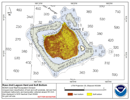
Preliminary hard and soft bottom seafloor substrate map (5m grid) derived from an unsupervised classification of gridded backscatter and bathymetry derivatives at Rose Atoll Lagoon, Territory of American Samoa, USA.
Abstract:
Preliminary hard and soft seafloor substrate map derived
from an unsupervised classification of multibeam backscatter and
bathymetry derivatives at Rose Atoll Lagoon, Territory of American Samoa, USA.
The dataset was created from gridded (5 m cell size) multibeam bathymetry derivatives collected
aboard R/V AHI; 2 scales of bathymetric variance and bathymetric rugosity, and from multibeam backscatter.
Backscatter data were from a 240 kHz Reson 8101 sonar, gridded at 5 m.
Very limited seafloor photographs for groundtruthing are available for Rose Atoll and therefore
no supervised classification was performed and we are unable to
visually or empirically evaluate the accuracy of the unsupervised
classification seafloor substrate map. However, in locations such
French Frigate Shoals, NWHI and Tutuila, American Samoa, where ground
truth data are available, the unsupervised classification method is a
robust predictor of substrate type in similar depth ranges and seafloor
environments.
Since groundtruthing was not used to validate the unsupervised classification at
Rose Atoll Lagoon extreme caution should be used when examining these data to locate
habitat of biological significance. The map should be used in conjunction with
bathymetric derivatives such as rugosity, slope, and Bathymetric Position Index (BPI).
Supplemental_Information:
Gridded multibeam data were collected aboard the R/V AHI (Acoustic Habitat Investigator),
a 25' survey launch owned and operated by the NOAA Pacific Islands Fisheries Science Center in
Honolulu, HI. The process for deriving the 5-m gridded multibeam bathymetry is described
in Rose_5m.asc.txt, available on www.soest.hawaii.edu/pibhmc.
The resulting grid (rose_5m.grd) was clipped using the ESRI ArcToolbox tool 'Extract by Mask' leaving only the multibeam data collected within the lagoon and excluding the narrow band of data around the upper
slopes of the atoll. Classification was carried out just for this lagoon area, as classification using the full multibeam dataset was heavily affected by artifacts within this narrow band of data.
The process for deriving the gridded multibeam backscatter
is described in rose-8101-bs-1m.grd.txt. These data are gridded at 1m. Prior to classification
the backscatter data were re-gridded at 5m, using the resample tool in the Arc Toolbox.
The rugosity data used in this classification is also available on the same website, metadata describing the
process of producing the rugosity grid is described in Rose_5m_rugosity.txt.
The bathymetric variance grids were generated for use in the classification process
and are not served separately. See the process description portion of this document
for additional informaiton about how the variance and unsupervised layers were derived.
A second classification was carried out using data collected on the slopes surrounding the atoll,
and these are served separately on www.soest.hawaii.edu/pibhmc. Metadata for this second classification
product is described in Rose_40m_hardsoft.txt.