 Map of percent scleractinian coral cover and sand along camera tow tracks in west Hawaii
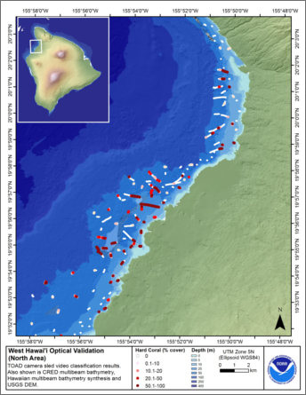 This map displays optical validation observation locations and percent coverage of scleractinian coral and sand overlaid on
bathymetry and landsat imagery northwest of Hawai'i island. Optical data were collected by CRED TOAD camera sled from the
Hawaiian ...
This map displays optical validation observation locations and percent coverage of scleractinian coral and sand overlaid on
bathymetry and landsat imagery northwest of Hawai'i island. Optical data were collected by CRED TOAD camera sled from the
Hawaiian ...