
Development of a network of no-take zones building on community based management initiatives for the Island Province of Kadavu, Fiji technical report
A combination of increased commercial fishing and larger local subsistence harvests has left most of Fiji's coastal waters overfished. Declining fisheries have been exacerbated by habitat decline caused by poor land-use practices, out-breaks of coral pred...
The coral reef [videorecording] : a hidden world / Peace Corps; University of South Pacific.
"The Coral Reef: A Hidden World" was a Peace Corps and the University of the South Pacific project designed to help educate Fijians about the value of the coral reefs in their waters. The video provides a valuable teaching tool for any classroom studying ...
Coral reef crime scene investigation (CSI) South East Asia and South Pacific final report
This project has been completed successfully both within the given timeframe and budget. All materials have been produced and the South East Asia (SEA) and South Pacific (SPAC) workshops successfully planned and implemented. Additional interest in the CSI...

CRED Reson 8101 multibeam backscatter data from the lagoon environment at Rose Island, American Samoa, South Pacific with 1 meter resolution in GeoTIFF format
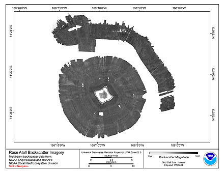
Multibeam backscatter imagery extracted from gridded bathymetry of Rose Island, American Samoa, South Pacific
These data provide coverage between 20 and 5000 meters. The backscatter dataset includes data collected using Simrad EM300 and
Reson 8101 multibe...
Report of the Workshop on Socio-economic Monitoring and Fisheries Management Planning for the Negril Marine Park 14 April 2005, Negril, Jamaica
Each session of the workshop had a specific objective contained in its presentation. Participants were expected to share their knowledge and opinions throughout; receiving more in the morning half that explained the research, and giving more in the aftern...
CRED Simrad em3002d multibeam backscatter data from the banktop and bank edge environments at Tutuila, American Samoa, South Pacific with 1 meter resolution in GeoTIFF format
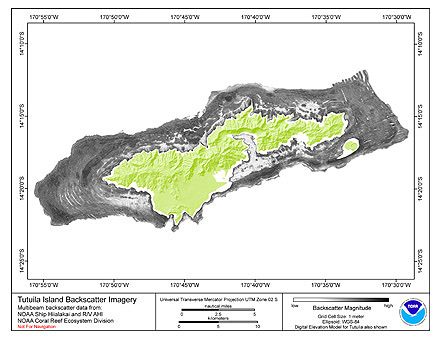
Multibeam backscatter imagery extracted from gridded bathymetry of Tutuila, American Samoa, South Pacific
These data provide coverage between 20 and 5000 meters. The backscatter dataset includes data collected using Simrad EM3002d and
Reson 8101 multibeam...
CRED Simrad em3002d multibeam backscatter data from the banktop and bank edge environments at Tutuila, American Samoa, South Pacific with 1 meter resolution in netCDF format
Multibeam backscatter imagery extracted from gridded bathymetry of Tutuila, American Samoa, South Pacific
These data provide coverage between 20 and 5000 meters. The backscatter dataset includes data collected using Simrad EM3002d and
Reson 8101 multibeam...
CRED Simrad em300 multibeam backscatter data from the submarine slope environment at Rose Island, American Samoa, South Pacific with 5 meter resolution in netCDF format
Multibeam backscatter imagery extracted from gridded bathymetry of Rose Island, American Samoa, South Pacific.
These data provide coverage between 20 and 5000 meters. The backscatter dataset includes data collected using Simrad EM300 and
Reson 8101 multib...
CRED Simrad em3002d multibeam backscatter data from the banktop and bank edge environments at Tutuila, American Samoa, South Pacific with 16 meter resolution in netCDF format
Multibeam backscatter imagery extracted from gridded bathymetry of Tutuila, American Samoa, South Pacific
These data provide coverage between 20 and 5000 meters. The backscatter dataset includes data collected using Simrad EM3002d and
Reson 8101 multibeam...
CRED Simrad em3002d multibeam backscatter data from the banktop and bank edge environments at Tutuila, American Samoa, South Pacific with 16 meter resolution in GeoTIFF format
Multibeam backscatter imagery extracted from gridded bathymetry of Tutuila, American Samoa, South Pacific
These data provide coverage between 20 and 5000 meters. The backscatter dataset includes data collected using Simrad EM3002d and
Reson 8101 multibeam...
CRED Reson 8101 multibeam backscatter data from the banktop and bank edge environments at Tutuila, American Samoa, South Pacific 16 meter resolution in netCDF format
Multibeam backscatter imagery extracted from gridded bathymetry of Tutuila, American Samoa, South Pacific
These data provide coverage between 20 and 5000 meters. The backscatter dataset includes data collected using Simrad EM3002d and
Reson 8101 multibeam...
CRED Reson 8101 multibeam backscatter data from the banktop and bank edge environments at Tutuila, American Samoa, South Pacific with 16 meter resolution in GeoTIFF format
Multibeam backscatter imagery extracted from gridded bathymetry of Tutuila, American Samoa, South Pacific
These data provide coverage between 20 and 5000 meters. The backscatter dataset includes data collected using Simrad EM3002d and
Reson 8101 multibeam...
CRED Reson 8101 multibeam backscatter data from the banktop and bank edge environments at Tutuila, American Samoa, South Pacific with 1 meter resolution in netCDF format
Multibeam backscatter imagery extracted from gridded bathymetry of Tutuila, American Samoa, South Pacific
These data provide coverage between 20 and 5000 meters. The backscatter dataset includes data collected using Simrad EM3002d and
Reson 8101 multibeam...
CRED Reson 8101 multibeam backscatter data from the banktop and bank edge environments at Tutuila, American Samoa, South Pacific with 1 meter resolution in GeoTIFF format
Multibeam backscatter imagery extracted from gridded bathymetry of Tutuila, American Samoa, South Pacific
These data provide coverage between 20 and 5000 meters. The backscatter dataset includes data collected using Simrad EM3002d and
Reson 8101 multibeam...
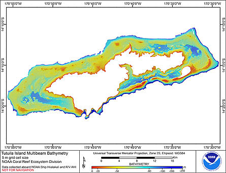 Gridded (5 m cell size) bathymetry of the shelf and slope environments
of Tutuila Island, American Samoa, South Pacific.
Almost complete bottom coverage was achieved in depths between
2 and 3409 meters (5 m grid includes data to 250 m). The bathymetry dat...
Gridded (5 m cell size) bathymetry of the shelf and slope environments
of Tutuila Island, American Samoa, South Pacific.
Almost complete bottom coverage was achieved in depths between
2 and 3409 meters (5 m grid includes data to 250 m). The bathymetry dat...
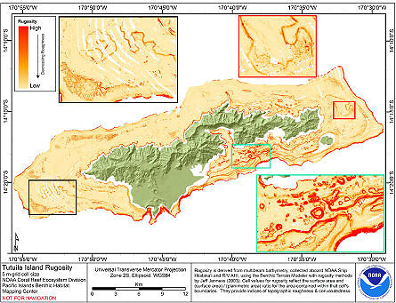 Rugosity is derived from gridded (5 m cell size) multibeam
bathymetry, collected aboard NOAA Ship Hiialaka'i and R/V AHI,
using the Benthic Terrain Modeler with rugosity methods by Jeff
Jenness (2003). Cell values reflect the surface area and
(surface are...
Rugosity is derived from gridded (5 m cell size) multibeam
bathymetry, collected aboard NOAA Ship Hiialaka'i and R/V AHI,
using the Benthic Terrain Modeler with rugosity methods by Jeff
Jenness (2003). Cell values reflect the surface area and
(surface are...
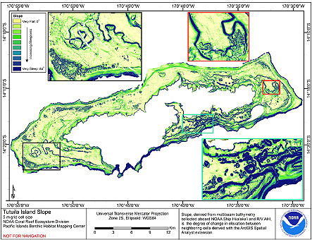 Slope is derived from gridded (5 m cell size) multibeam
bathymetry, collected aboard NOAA Ship Hiialaka'i and R/V AHI,
Cell values reflect the maximum rate of change (in degrees) in
elevation between neighboring cells derived with the ArcGIS
Spatial Analy...
Slope is derived from gridded (5 m cell size) multibeam
bathymetry, collected aboard NOAA Ship Hiialaka'i and R/V AHI,
Cell values reflect the maximum rate of change (in degrees) in
elevation between neighboring cells derived with the ArcGIS
Spatial Analy...
 Multibeam backscatter imagery extracted from gridded bathymetry of Rose Island, American Samoa, South Pacific
These data provide coverage between 20 and 5000 meters. The backscatter dataset includes data collected using Simrad EM300 and
Reson 8101 multibe...
Multibeam backscatter imagery extracted from gridded bathymetry of Rose Island, American Samoa, South Pacific
These data provide coverage between 20 and 5000 meters. The backscatter dataset includes data collected using Simrad EM300 and
Reson 8101 multibe...
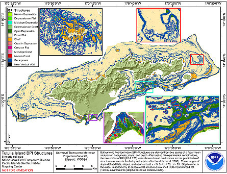 BPI Structures are derived from two scales of a focal mean
analysis on bathymetry; slope; and depth. The grid is based on
gridded (5 m cell size) multibeam bathymetry, collected aboard NOAA
Ship Hiialaka'i and R/V AHI, and it was creating using the Benthi...
BPI Structures are derived from two scales of a focal mean
analysis on bathymetry; slope; and depth. The grid is based on
gridded (5 m cell size) multibeam bathymetry, collected aboard NOAA
Ship Hiialaka'i and R/V AHI, and it was creating using the Benthi...
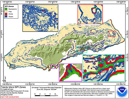 BPI Zones are derived from a focal mean analysis on
bathymetry and slope. The grid is based on gridded (5 m cell size)
multibeam bathymetry, collected aboard NOAA Ship Hi'ialakai and
R/V AHI, and it was creating using the Benthic Terrain Modeler
(http://w...
BPI Zones are derived from a focal mean analysis on
bathymetry and slope. The grid is based on gridded (5 m cell size)
multibeam bathymetry, collected aboard NOAA Ship Hi'ialakai and
R/V AHI, and it was creating using the Benthic Terrain Modeler
(http://w...
 This Paleoclimatology Study is archived at and available from the NOAA National Centers for Environmental Information (NCEI), under the World Data Service (WDS) for Paleoclimatology. The NOAA Paleoclimatology Study Type is Coral. The data include paramete...
 Multibeam backscatter imagery extracted from gridded bathymetry of Tutuila, American Samoa, South Pacific
These data provide coverage between 20 and 5000 meters. The backscatter dataset includes data collected using Simrad EM3002d and
Reson 8101 multibeam...
Multibeam backscatter imagery extracted from gridded bathymetry of Tutuila, American Samoa, South Pacific
These data provide coverage between 20 and 5000 meters. The backscatter dataset includes data collected using Simrad EM3002d and
Reson 8101 multibeam...
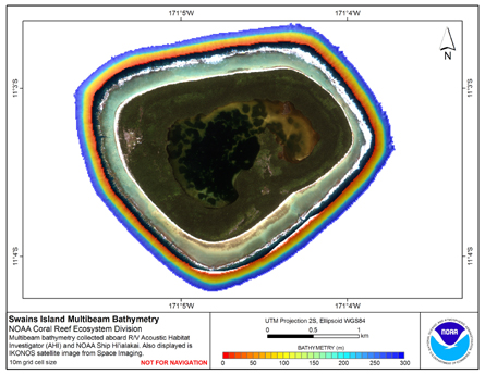 Gridded (10 m cell size) bathymetry of the slope environment of
Swains Island, American Samoa, South Pacific.
Almost complete bottom coverage was achieved in depths between
7 and 4800 meters (10 m grid includes data to 300 m). The bathymetry dataset
inclu...
Gridded (10 m cell size) bathymetry of the slope environment of
Swains Island, American Samoa, South Pacific.
Almost complete bottom coverage was achieved in depths between
7 and 4800 meters (10 m grid includes data to 300 m). The bathymetry dataset
inclu...