Quantifying condition of coral reef communities in the Kahana and Honokahua Priority Watersheds, West Maui Project Information
"The Hawaii Coral Reef Strategy identified the coral reef ecosystem along the West Maui watersheds (Ka'anapali to Honolua) as a State Priority Management Area. Coral reefs in the region are severely affected by sedimentation and siltation stress, due to e...
Determining Watershed Management Efficacy in West Maui: Belt transect surveys of coral demography (adult and juvenile corals) from 2014 to 2015
The focus of the Wahikuli-Honokowai Watershed Management Plan is the land use practices and alterations affected in the agricultural and urban districts that have upset the natural drainage patterns and ecohydrologic balance and services the watersheds pr...
Determining the efficacy of watershed management in the Wahikuli and Honokowai watersheds, West Maui
Purpose/need: The Hawaii Coral Reef Strategy identified the coral reef ecosystem along the West Maui watersheds (Ka’anapali to Honolua) as a State Priority Management Area. Coral reefs in the region are severely affected by sedimentation and siltation str...
Determining Watershed Management Efficacy in West Maui: line-point-intercept and photo quadrat surveys of benthic communities for benthic cover from 2014 to 2015
The focus of the Wahikuli-Honokowai Watershed Management Plan is the land use practices and alterations affected in the agricultural and urban districts that have upset the natural drainage patterns and ecohydrologic balance and services the watersheds pr...
Quantifying condition of coral reef communities in the Kahana and Honokahua Priority Watersheds, West Maui Project Information
The Hawaii Coral Reef Strategy identified the coral reef ecosystem along the West Maui watersheds (Ka’anapali to Honolua) as a State Priority Management Area. Coral reefs in the region are severely affected by sedimentation and siltation stress, due to ex...
Quantifying condition of coral reef communities in the Kahana and Honokahua Priority Watersheds, West Maui.
2017 UPDATE: This project will address continue data collection in the W Maui area that have been the center of CRCP-supported monitoring efforts. Last year's project "FY16 Quantifying condition of coral reef communities in the Kahana and Honokahua Priori...
"This initiative is an all-encompassing approach across multiple agencies, organizations, and jurisdictions to address adverse impacts to coral reefs in West Maui. The proposed 24,000-acre study area extends from Ka`anapali northward to Honolua and from t...
West Maui Wahikuli and Honokowai priority watershed area: Reef condition report
"The State of Hawaii and partners established the West Maui Priority Watershed Area in year 2010 with the intent of making this a focal location for coral reef research and management initiatives. The USCRTF added a priority watershed partnership designat...
West Maui, Hawaii, Coastal Uses Participatory Mapping Project, 2011
The West Maui Coastal use Participatory Mapping Project was developed through a partnership between the Hawaii State Division of Aquatic Resources (HDAR), NOAA's Pacific Islands Regional Office (PIRO), NOAA Coral Reef Conservation Program (CRCP) and NOAA'...
Wahikuli-Honokowai Coastal Conservation Action Plan
"This plan was developed by a multidisciplinary project team who convened at four workshops from 2011- 2013 as part of a peer planning and learning process with two other marine sites, Molokini Shoal Marine Life Conservation District (MLCD) and Kahoolawe ...
Baseline assessments for coral reef community structure and demographics on West Maui : data report
The coastal and upslope terrains of West Maui have had a long history of impacts owing to more than a century of human activities. Resource extraction, agriculture, as well as residential and resort development have caused land-based pollution that impair...
Wahikuli-Honokowai Wildfire Mitigation Plan: Reducing wildfire hazards and impacts in the Wahikuli-Honokowai watersheds
"This Wahikuli-Honokowai Wildfire Mitigation Plan was written to provide resource managers and landowners with a comprehensive wildfire readiness plan. It provides an overview of pre-fire hazard reduction recommendations and outlines the preparation neede...
Monitoring of Coral Reef Ecosystems on Maui, Hawaii during 1989-1998 (NODC Accession 9900242)
In an effort to detect spatial and temporal changes in the structure of the
coral reef community, coral coverage and reef fish density and diversity
were documented at selected sites along the Maui coastline using standard
transect methodology and S...
The purpose of this report is to characterize the pollutant loading and restoration potential of the 46.4-acre study area mauka of the Honokowai Beach Park (HBP), which was identified in the Wahikuli-Honokowai Watershed Management Plan (WHWMP) as a locati...
Determining the effectiveness of watershed management activities to reduce land-based pollution on West Maui
"As an approach to reduce the effects of land-based sources of pollution on coral reefs, the U.S. Coral Reef Task Force and NOAA's Coral Reef Conservation Program identified West Maui as one of two Pacific Region priority areas for the implementation of t...
Delineate, Designate, and Demonstrate Stream Riparian Buffers in Wahikuli, West Maui
"West Maui has been designated a priority conservation site by state and federal governments in an effort to address land-based pollution and corresponding declines in coral cover. Several West Maui Watershed plans identify erosion from degraded agricultu...
"In response to concerns about the long-term decline of local coral reefs, the state of Hawaii created the Kahekili Herbivore Fishery Management Area (KHFMA) along an approximately 2-mile stretch of coastline in Ka'anapali, West Maui (see picture right). ...
West Maui Coastal Uses Participatory Mapping Project : human uses map book : results from participatory coastal use mapping workshops, Honolua-Wahikuli Region, West Maui, Kaunoa Center, Lahaiana, August 10-13th, 2011
This map book contains cartographic products derived from the West Maui Human Coastal Use Mapping project conducted at the Kaunoa Senior Center in Lahaina, Maui from Thursday, August 10th to Saturday, August 13th, 2011. Data was obtained through a partici...
West Maui Wahikuli & Honokōwai priority watershed area : reef condition report
The State of Hawaii and partners established the West Maui Priority Watershed Area in year 2010 with the intent of making this a focal location for coral reef research and management initiatives. The USCRTF added a priority watershed partnership designati...
Results brief : 5 years of protection at Kahekili Herbivore Fisheries Management Area
In response to concerns about long-term declines on local reefs, in 2009, the State of Hawaii established the Kahekili Herbivore Fisheries Management Area (KHFMA) in Ka'anapali, West Maui. Within the KHFMA, herbivorous fishes and sea urchins are protected...
Improve Coral Reef Health by Expanding and Leveraging Stream Gulch Restoration Actions in Wahikuli, West Maui
"The Wahikuli-Honokowai Watershed Management Plan recommended a number of management strategies to address the issue of sedimentation. The Coral Reef Alliance (CORAL) is grateful to the National Oceanic and Atmospheric Administration for this funding towa...
Design, development, and implementation of a survey of the fisheries of the Kahekili Herbivore Fisheries Management Area
The Kahekili Herbivore Fisheries Management Area (KHFMA), Maui has been established to control the overabundance of marine algae within the area by increasing the local abundance of certain herbivorous fishes and sea urchins by fisheries management method...
Enhancing the Effectiveness of Restoration Efforts in Honokowai and Kapunakea Preserve
"The project was focused on the continuation of reducing sediment transport within the Honokowai watershed. The focus particularly is on the impact of dirt roads and the resulting transport of sediment from these roads during rainfall events to the adjace...
West Maui non-directional wave and tide data taken during October 2003
through February 2004 at 3 stations in depths less than 11 meters. (NODC Accession 0037899)
US Geological Survey (USGS) Western Region Coastal and Marine Geology Team
deployed National Institute of Water and Atmospheric Research, New Zealand
(NIWA) Dobie-A non-directional wave gauges in 3 nearshore areas of western
Maui during October 2003 - Feb...
Summary of Rain Garden Installation Clinic and additional retrofit reconnaissance
"This memorandum provides a brief summary of the March 15-16, 2013 Rain Garden Installation Clinic at the Lahaina Civic Center and the Wahikuli Wayside Park in West Maui. The purpose of the clinic was to: 1) initiate implementation of the 2012 Wahikuli-Ho...
 Quantifying condition of coral reef communities in the Kahana and Honokahua Priority Watersheds, West Maui Project Information
 Determining Watershed Management Efficacy in West Maui: Belt transect surveys of coral demography (adult and juvenile corals) from 2014 to 2015
 The focus of the Wahikuli-Honokowai Watershed Management Plan is the land use practices and alterations affected in the agricultural and urban districts that have upset the natural drainage patterns and ecohydrologic balance and services the watersheds pr...
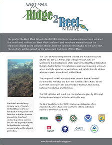 "This initiative is an all-encompassing approach across multiple agencies, organizations, and jurisdictions to address adverse impacts to coral reefs in West Maui. The proposed 24,000-acre study area extends from Ka`anapali northward to Honolua and from t...
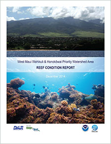 "The State of Hawaii and partners established the West Maui Priority Watershed Area in year 2010 with the intent of making this a focal location for coral reef research and management initiatives. The USCRTF added a priority watershed partnership designat...
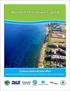 "This plan was developed by a multidisciplinary project team who convened at four workshops from 2011- 2013 as part of a peer planning and learning process with two other marine sites, Molokini Shoal Marine Life Conservation District (MLCD) and Kahoolawe ...