CRED REA Reef Fish Assessment Survey at Guam Island, Marianas Archipelago in 2009
To support a long-term NOAA Coral Reef Conservation Program (CRCP) for sustainable management and conservation of coral reef ecosystems, from 5 April - 14 April 2009, reef fish assessment surveys were conducted, as a part of Rapid Ecological Assessments (...
Guam Community Coral Reef Monitoring Program,
Benthic Training Surveys at Guam in 2012
Guam community members gathered benthic cover data using a 0.25m2 quadrat with 6 intersecting points at each meter along a 25-meter transect. Members identified corals and algae to genus (when possible), seagrass to species, and sponges to phylum. Data is...
CRED Optical Validation Data at the island of Guam, Commonwealth of the Northern Mariana Islands, 2003, to Support Benthic Habitat Mapping
Optical validation data were collected using a Tethered Optical Assessment Device (TOAD), an underwater
sled equipped with an underwater digital video camera and lights. Data were collected in the U.S. territory of
Guam, around the island of Guam itself a...
What you need to know about marine invasive species
"This information brief was produced in cooperation with the Guam Bureau of Statistics and Plans, NOAA Coral Reef Conservation Program, Guam Coastal Management Program, and the University of Guam Center for Island Sustainability. It provides information o...
Background for Micronesia Challenge monitoring protocols and assessment framework
"The reef-assessment protocol was designed to address the highest priority management questions at both local and regional scales. Accordingly, sites were stratified across (i) management regimes, (ii) wave exposure, (iii) islands, and (iv) major reef hab...
CRED REA Line Point Intercept Surveys of Benthic Parameter Assessments at Guam Island, Marianas Archipelago in 2007
To support a long-term NOAA Coral Reef Conservation Program (CRCP) for sustainable management and conservation of coral reef ecosystems, from 12 - 22 May 2007, line point intercept (LPI) surveys of benthic parameter assessments were conducted, as a part o...
These images are part of a project funded by NOAA Office for Coastal Management to develop a high quality, user-friendly, attributed, centralized, multi-territorial digital database of georeferenced historic aerial imagery in the Pacific Islands region, i...
These images are part of a project funded by NOAA Office for Coastal Management to develop a high quality, user-friendly, attributed, centralized, multi-territorial digital database of georeferenced historic aerial imagery in the Pacific Islands region, i...
These images are part of a project funded by NOAA Office for Coastal Management to develop a high quality, user-friendly, attributed, centralized, multi-territorial digital database of georeferenced historic aerial imagery in the Pacific Islands region, i...
These images are part of a project funded by NOAA Office for Coastal Management to develop a high quality, user-friendly, attributed, centralized, multi-territorial digital database of georeferenced historic aerial imagery in the Pacific Islands region, i...
 CRED REA Reef Fish Assessment Survey at Guam Island, Marianas Archipelago in 2009
 What you need to know about marine invasive species
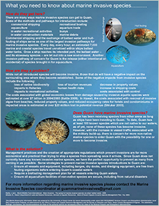 "This information brief was produced in cooperation with the Guam Bureau of Statistics and Plans, NOAA Coral Reef Conservation Program, Guam Coastal Management Program, and the University of Guam Center for Island Sustainability. It provides information o...
 1953 Guam Historical Scanned Imagery