
2000 Hawaii State-wide and 2000-2002 Kaneohe Bay, Oahu Marine Alien and/or Invasive Algae Species Surveys (NODC Accession 0001007)
Baseline surveys were conducted at numerous sites around each island, including those identified as "hotspots" by the Department of Aquatic Resources, around the islands of Hawaii, Maui, Molokai, Oahu and Kauai. A total of 72 sites with 13 in Kaneohe Bay,...
Gridded bathymetry of Midway Atoll, Hawaii, USA
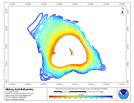
Gridded bathymetry of the shelf and slope environments of Midway Atoll,
Hawaii, USA. Bottom coverage was achieved in depths between 0 and 200 meters.
The ASCII includes multibeam bathymetry from the Simrad EM300, Simrad EM3002d,
and Reson 8101 multibeam s...
CRED 20m Gridded bathymetry and IKONOS estimated depths of Kure Atoll, Hawaii, USA (Arc ASCII format)
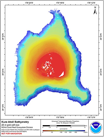
Gridded bathymetry and IKONOS estimated depths of the shelf and slope
environments of Kure Atoll, Hawaii, USA. Bottom coverage was achieved in
depths between 0 and 2000 meters. The ASCII grid includes multibeam bathymetry
from the Simrad EM300, Simrad EM3...
CRED 20m Gridded bathymetry and IKONOS estimated depths of Kure Atoll, Hawaii, USA (NetCDF Format)
Gridded bathymetry and IKONOS estimated depths of the shelf and slope
environments of Kure Atoll, Hawaii, USA. Bottom coverage was achieved in
depths between 0 and 2000 meters. The netCDF grid includes multibeam bathymetry
from the Simrad EM300, Simrad EM...
CRED 20 m Gridded bathymetry and IKONOS estimated depths of Lisianski Island, Hawaii, USA (Arc ASCII format)
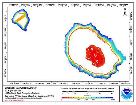
Gridded bathymetry and IKONOS estimated depths of the shelf and slope environments
of Lisianski Island, Northwestern Hawaiian Islands, Hawaii, USA. Bottom coverage was
achieved in depths between 0 and 5000 meters.The ASCII includes multibeam bathymetry
fr...
CRED 20 m Gridded bathymetry and IKONOS estimated depths of Lisianski Island, Northwestern Hawaiian Islands, USA (NetCDF format)
Gridded bathymetry and IKONOS estimated depths of the shelf and slope environments
of Lisianski Island, Northwestern Hawaiian Islands, Hawaii, USA. Bottom coverage was
achieved in depths between 0 and 5000 meters.The netCDF includes multibeam bathymetry
f...
CRED 20m Gridded bathymetry and IKONOS estimated depths of Maro Reef, Hawaii, USA (Arc ASCII format)
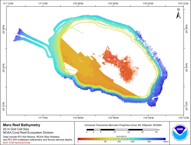
Gridded bathymetry and IKONOS estimated depths of the shelf and slope
environments of Maro Reef, Hawaii, USA. Bottom coverage was achieved in depths
between 0 and 3000 meters. The ASCII includes multibeam bathymetry from the
Simrad EM120, Simrad EM1002 Si...
CRED 20m Gridded bathymetry and IKONOS estimated depths of Maro Reef, Hawaii, USA (NetCDF Format)
Gridded bathymetry and IKONOS estimated depths of the shelf and slope
environments of Maro Reef, Hawaii, USA. Bottom coverage was achieved in depths
between 0 and 3000 meters. The netCDF includes multibeam bathymetry from the
Simrad EM120, Simrad EM1002 S...
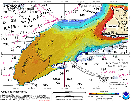 Gridded bathymetry (5 m cell size) of Penguin Bank, Hawaii, USA.
The netCDF grid and ArcGIS ASCII file include multibeam bathymetry from the Simrad
EM3002d, and Reson 8101 multibeam sonars collected during cruises in 2005 and 2006
by the NOAA Coral Reef E...
Gridded bathymetry (5 m cell size) of Penguin Bank, Hawaii, USA.
The netCDF grid and ArcGIS ASCII file include multibeam bathymetry from the Simrad
EM3002d, and Reson 8101 multibeam sonars collected during cruises in 2005 and 2006
by the NOAA Coral Reef E...
 Gridded bathymetry of the shelf and slope environments of Midway Atoll,
Hawaii, USA. Bottom coverage was achieved in depths between 0 and 200 meters.
The ASCII includes multibeam bathymetry from the Simrad EM300, Simrad EM3002d,
and Reson 8101 multibeam s...
Gridded bathymetry of the shelf and slope environments of Midway Atoll,
Hawaii, USA. Bottom coverage was achieved in depths between 0 and 200 meters.
The ASCII includes multibeam bathymetry from the Simrad EM300, Simrad EM3002d,
and Reson 8101 multibeam s...
 Gridded bathymetry and IKONOS estimated depths of the shelf and slope
environments of Kure Atoll, Hawaii, USA. Bottom coverage was achieved in
depths between 0 and 2000 meters. The ASCII grid includes multibeam bathymetry
from the Simrad EM300, Simrad EM3...
Gridded bathymetry and IKONOS estimated depths of the shelf and slope
environments of Kure Atoll, Hawaii, USA. Bottom coverage was achieved in
depths between 0 and 2000 meters. The ASCII grid includes multibeam bathymetry
from the Simrad EM300, Simrad EM3...
 Gridded bathymetry and IKONOS estimated depths of the shelf and slope environments
of Lisianski Island, Northwestern Hawaiian Islands, Hawaii, USA. Bottom coverage was
achieved in depths between 0 and 5000 meters.The ASCII includes multibeam bathymetry
fr...
Gridded bathymetry and IKONOS estimated depths of the shelf and slope environments
of Lisianski Island, Northwestern Hawaiian Islands, Hawaii, USA. Bottom coverage was
achieved in depths between 0 and 5000 meters.The ASCII includes multibeam bathymetry
fr...
 Gridded bathymetry and IKONOS estimated depths of the shelf and slope
environments of Maro Reef, Hawaii, USA. Bottom coverage was achieved in depths
between 0 and 3000 meters. The ASCII includes multibeam bathymetry from the
Simrad EM120, Simrad EM1002 Si...
Gridded bathymetry and IKONOS estimated depths of the shelf and slope
environments of Maro Reef, Hawaii, USA. Bottom coverage was achieved in depths
between 0 and 3000 meters. The ASCII includes multibeam bathymetry from the
Simrad EM120, Simrad EM1002 Si...