
Linkages between reef fish demographics and benthic habitat characteristics in Tutuila, American Samoa and Main Hawaiian Islands
Benthic habitats play vital roles in the distribution and abundances of marine resources. Understanding how fish populations respond to variability of benthic habitat characteristics is essential for effective coral reef management and monitoring. A pilot...

Benthic percent cover derived from image analysis for selected locations in the Pacific Ocean
The data products described herein are part of the NOAA Coral Reef Conservation Program (CRCP) funded projects aimed at documenting the status and trends for benthic cover and composition on coral reef ecosystems across the U.S. Pacific States and Territo...
Integrated hard and soft bottom seafloor substrate map of Ofu-Olosega, American Samoa, combining
NOAA Pacific Island Fisheries Science Center Coral Reef Ecosystem Division
hard-soft substrate map with NOAA Center for Coastal Monitoring and Assessment
Biogeography Program shallow-water benthic habitat
map of American Samoa.
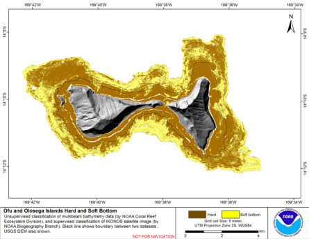
Hard and soft seafloor substrate map, derived from integrating
two existing map products: hard and soft seafloor substrate map
derived from an unsupervised classification of multibeam backscatter and
bathymetry derivatives, produced by NOAA Pacific Island...
Sampling grids to support the collection and analysis of survey data for the National Coral Reef Monitoring Program in American Samoa, Pacific Remote Islands Areas, Main Hawaiian Islands
The sampling grids are identified as essential components for the stratified random sampling design of the National Coral Reef Monitoring Program (NCRMP). The benthic habitat map layers including bathymetry, hard and soft substrates, reef zones and sector...
Integrated hard and soft bottom seafloor substrate map of Ta'u, American Samoa, combining
NOAA Pacific Island Fisheries Science Center Coral Reef Ecosystem Division
hard-soft substrate map with NOAA Center for Coastal Monitoring and Assessment
Biogeography Program shallow-water benthic habitat
map of American Samoa.
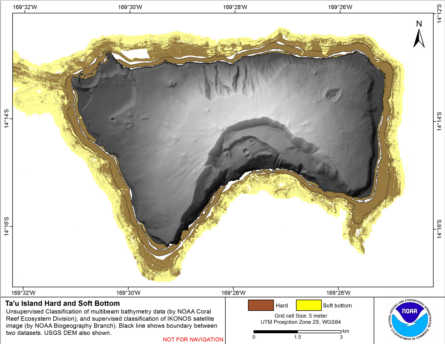
Hard and soft seafloor substrate map, derived from integrating
two existing map products: hard and soft seafloor substrate map
derived from an unsupervised classification of multibeam backscatter and
bathymetry derivatives, produced by NOAA Pacific Island...
Integrated hard and soft bottom seafloor substrate map of Rose Atoll, American Samoa
combining NOAA Pacific Island Fisheries Science Center Coral Reef Ecosystem Division
hard-soft substrate maps with NOAA Center for Coastal Monitoring and Assessment Biogeography
Program shallow-water benthic habitat map of American Samoa.
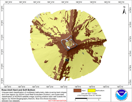
Hard and soft seafloor substrate map, derived from integrating two existing map
products: hard and soft substrate maps derived from an unsupervised classification of multibeam
backscatter and bathymetry derivatives, produced by NOAA Pacific Island Fisheri...
Pacific Reef Assessment and Monitoring Program: Calcification Rates of Crustose Coralline Algae Derived from Calcification Accretion Units (CAUs) Deployed across American Samoa and the Pacific Remote Island Areas in 2010

Calcification accretion units, or CAUs, are used to assess the current effects of changes in seawater carbonate chemistry on calcification and accretion rates of calcareous and fleshy algae in the Hawaiian and Mariana Archipelagos, American Samoa, and the...
CRED Fish Observations from Stereo Video Cameras on a SeaBED AUV collected around Tutuila, American Samoa in 2012
Black and white imagery were collected using a stereo pair of underwater video cameras mounted on a SeaBED autonomous
underwater vehicle (AUV) and deployed around the island of Tutuila in American Samoa to record observations of fishes
encountered there. ...
Coral reef ecosystem marine protected area monitoring in Fagamalo, American Samoa: benthic images collected during belt transect surveys in 2015
In 2010 the village of Fagamalo, Tutuila, American Samoa, designated a no-take Marine Protected Area that sees the protection of 2.25 square kilometers of ocean. Because little is known regarding the status of living marine communities in the area, and at...
 Hard and soft seafloor substrate map, derived from integrating
two existing map products: hard and soft seafloor substrate map
derived from an unsupervised classification of multibeam backscatter and
bathymetry derivatives, produced by NOAA Pacific Island...
Hard and soft seafloor substrate map, derived from integrating
two existing map products: hard and soft seafloor substrate map
derived from an unsupervised classification of multibeam backscatter and
bathymetry derivatives, produced by NOAA Pacific Island...
 Hard and soft seafloor substrate map, derived from integrating two existing map
products: hard and soft substrate maps derived from an unsupervised classification of multibeam
backscatter and bathymetry derivatives, produced by NOAA Pacific Island Fisheri...
Hard and soft seafloor substrate map, derived from integrating two existing map
products: hard and soft substrate maps derived from an unsupervised classification of multibeam
backscatter and bathymetry derivatives, produced by NOAA Pacific Island Fisheri...
 Calcification accretion units, or CAUs, are used to assess the current effects of changes in seawater carbonate chemistry on calcification and accretion rates of calcareous and fleshy algae in the Hawaiian and Mariana Archipelagos, American Samoa, and the...
 The data described herein are part of a NOAA Coral Reef Conservation Program (CRCP) funded project aimed at establishing baseline data for coral demographics and benthic cover and composition via Rapid Ecological Assessment (REA) surveys conducted by the ...