EM300 Multibeam Sonar Data collected from May 7 to May 22 from NOAA Ship Hi'ialakai cruise HA-17-01 to the Commonwealth of Northern Mariana Islands (CNMI) and Guam in 2017
Multibeam data were collected using a Simrad EM300 30-kHz sonar aboard NOAA Ship Hi'ialakai, a 68-m (218') NOAA research vessel, from May 7 to May 22, 2017 during cruise HA-17-01. Multibeam data were acquired at Guam and Aguijan in the Marianas. The multi...
Water temperature data from reef sites off the upper Florida Keys from 2003-09-18 to 2023-12-31 (NCEI Accession 0126994)
Temperature loggers were deployed at various monitoring sites off the upper Florida Keys where other ecological studies were underway, most focused on aspects of Acropora spp. status or ecology. Hobo Tidbit® or Pendant® loggers were secured to the substra...
Gridded multibeam bathymetry of Guam Island, Guam U.S. Territory
Gridded bathymetry at 60m resolution surrounding Guam Island, Guam U.S. Territory. Bottom coverage was achieved in depths between 0 and ~3500 meters. The Arc ASCII grids and floating point geotifs include multibeam bathymetry data acquired over multiple s...
EM300 Multibeam Sonar Data collected from January 26 to April 22 from NOAA Ship Hi'ialakai cruise HA-15-01 to the Pacific Remote Island Areas and American Samoa in 2015
Multibeam data were collected using a Simrad EM300 30-kHz sonar aboard NOAA Ship Hi'ialakai, a 68-m (218') NOAA research vessel, from January 26 to April 22, 2015 during cruise HA-15-01. Multibeam data were acquired at Johnston, Howland, Baker, Jarvis, an...
Bathymetric Position Index (BPI) Zones Grid Derived from Gridded Bathymetry for Select U.S. Coral Reef Locations across the Pacific Ocean
Bathymetric Position Index (BPI) Zones are derived for islands and banks across the U.S. Pacific Islands Region from a focal mean analysis on bathymetry and slope, and were created using the Benthic Terrain Modeler. Cell values represent one of 4 classes ...
Bathymetric Position Index (BPI) Structures Grid Derived from Gridded Bathymetry for Select U.S. Coral Reef Locations across the Pacific Ocean
Bathymetric Position Index (BPI) Structures are derived for islands and banks across the U.S. Pacific Islands Region from a focal mean analysis on bathymetry and slope, and were created using the Benthic Terrain Modeler. Cell values represent one of 13 cl...
Rugosity Grid Derived from Gridded Bathymetry for Select U.S. Coral Reef Locations across the Pacific Ocean
Rugosity is derived for islands and banks across the U.S. Pacific Islands Region primarily from gridded multibeam bathymetry collected aboard NOAA Ships Hi'ialakai and Oscar Elton Sette, and aboard R/V AHI (Acoustic Habitat Investigator) from 2003 to 2012...
Slope Grid Derived from Gridded Bathymetry for Select U.S. Coral Reef Locations across the Pacific Ocean
Slope is derived for islands and banks across the U.S. Pacific Islands Region primarily from gridded multibeam bathymetry collected aboard NOAA Ships Hi'ialakai and Oscar Elton Sette, and aboard R/V AHI (Acoustic Habitat Investigator) from 2003 to 2012 by...
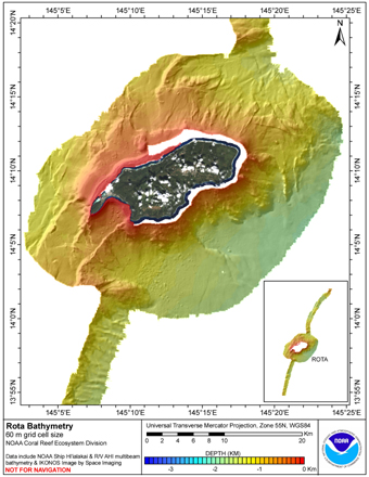
5 m Gridded multibeam bathymetry of Rota Island, Commonwealth of the Northern Mariana Islands (CNMI)
Rota Island, CNMI. Bottom coverage was achieved in depths
between 0 and -1905 meters; this 5-m grid has data only to
-400 m. The netCDF and Arc ASCII grids include multibeam
bathymetry from the Simrad EM300 and Reson 8101 multibeam sonars
collected as o...
4 km AVHRR Pathfinder v5.0 Global Day-Night Sea Surface Temperature Averages, 1985-2009 (NODC Accession 0077816)
This data set contains a set of monthly and yearly global day-night sea surface temperature averages, derived from the AVHRR Pathfinder Version 5 sea surface temperature cloudscreened data set (http://pathfinder.nodc.noaa.gov) in GeoTIFF format. The AVHRR...
 EM300 Multibeam Sonar Data collected from May 7 to May 22 from NOAA Ship Hi'ialakai cruise HA-17-01 to the Commonwealth of Northern Mariana Islands (CNMI) and Guam in 2017
 Gridded bathymetry at 60m resolution surrounding Guam Island, Guam U.S. Territory. Bottom coverage was achieved in depths between 0 and ~3500 meters. The Arc ASCII grids and floating point geotifs include multibeam bathymetry data acquired over multiple s...
 Rota Island, CNMI. Bottom coverage was achieved in depths
between 0 and -1905 meters; this 5-m grid has data only to
-400 m. The netCDF and Arc ASCII grids include multibeam
bathymetry from the Simrad EM300 and Reson 8101 multibeam sonars
collected as o...
Rota Island, CNMI. Bottom coverage was achieved in depths
between 0 and -1905 meters; this 5-m grid has data only to
-400 m. The netCDF and Arc ASCII grids include multibeam
bathymetry from the Simrad EM300 and Reson 8101 multibeam sonars
collected as o...
 This data set contains a set of monthly and yearly global day-night sea surface temperature averages, derived from the AVHRR Pathfinder Version 5 sea surface temperature cloudscreened data set (http://pathfinder.nodc.noaa.gov) in GeoTIFF format. The AVHRR...