
Eco-spatial data layers of coral reef ecosystem drivers in American Samoa
Understanding the spatial distribution, intensity, overlap, and cumulative impact of human activities and environmental stressors is essential for effective management and protection of ecosystem services generated by coral reefs. The data described here ...
Integrated hard and soft bottom seafloor substrate map of Ofu-Olosega, American Samoa, combining
NOAA Pacific Island Fisheries Science Center Coral Reef Ecosystem Division
hard-soft substrate map with NOAA Center for Coastal Monitoring and Assessment
Biogeography Program shallow-water benthic habitat
map of American Samoa.
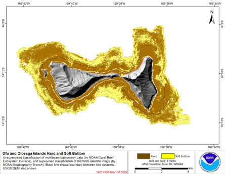
Hard and soft seafloor substrate map, derived from integrating
two existing map products: hard and soft seafloor substrate map
derived from an unsupervised classification of multibeam backscatter and
bathymetry derivatives, produced by NOAA Pacific Island...
Integrated hard and soft bottom seafloor substrate map of Ta'u, American Samoa, combining
NOAA Pacific Island Fisheries Science Center Coral Reef Ecosystem Division
hard-soft substrate map with NOAA Center for Coastal Monitoring and Assessment
Biogeography Program shallow-water benthic habitat
map of American Samoa.
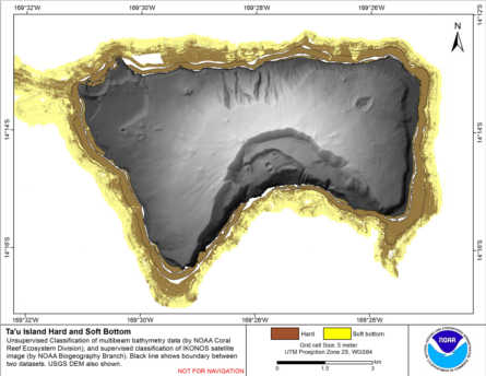
Hard and soft seafloor substrate map, derived from integrating
two existing map products: hard and soft seafloor substrate map
derived from an unsupervised classification of multibeam backscatter and
bathymetry derivatives, produced by NOAA Pacific Island...
Integrated hard and soft bottom seafloor substrate map of Rose Atoll, American Samoa
combining NOAA Pacific Island Fisheries Science Center Coral Reef Ecosystem Division
hard-soft substrate maps with NOAA Center for Coastal Monitoring and Assessment Biogeography
Program shallow-water benthic habitat map of American Samoa.
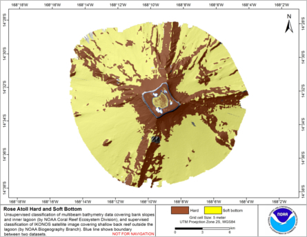
Hard and soft seafloor substrate map, derived from integrating two existing map
products: hard and soft substrate maps derived from an unsupervised classification of multibeam
backscatter and bathymetry derivatives, produced by NOAA Pacific Island Fisheri...

Benthic percent cover derived from image analysis for selected locations in the Pacific Ocean
The data products described herein are part of the NOAA Coral Reef Conservation Program (CRCP) funded projects aimed at documenting the status and trends for benthic cover and composition on coral reef ecosystems across the U.S. Pacific States and Territo...
Rugosity Grid Derived from Gridded Bathymetry for Select U.S. Coral Reef Locations across the Pacific Ocean
Rugosity is derived for islands and banks across the U.S. Pacific Islands Region primarily from gridded multibeam bathymetry collected aboard NOAA Ships Hi'ialakai and Oscar Elton Sette, and aboard R/V AHI (Acoustic Habitat Investigator) from 2003 to 2012...
Benthic Surveys in Vatia, American Samoa since 2015: benthic images collected during belt transect surveys in 2015
Jurisdictional managers have expressed concerns that nutrients from the village of Vatia, Tutuila, American Samoa, are having an adverse effect on the coral reef ecosystem in Vatia Bay. Excess nutrient loads promote increases in algal growth that can have...
 Hard and soft seafloor substrate map, derived from integrating
two existing map products: hard and soft seafloor substrate map
derived from an unsupervised classification of multibeam backscatter and
bathymetry derivatives, produced by NOAA Pacific Island...
Hard and soft seafloor substrate map, derived from integrating
two existing map products: hard and soft seafloor substrate map
derived from an unsupervised classification of multibeam backscatter and
bathymetry derivatives, produced by NOAA Pacific Island...
 Hard and soft seafloor substrate map, derived from integrating two existing map
products: hard and soft substrate maps derived from an unsupervised classification of multibeam
backscatter and bathymetry derivatives, produced by NOAA Pacific Island Fisheri...
Hard and soft seafloor substrate map, derived from integrating two existing map
products: hard and soft substrate maps derived from an unsupervised classification of multibeam
backscatter and bathymetry derivatives, produced by NOAA Pacific Island Fisheri...
 This interactive map displays American Samoa data collected by the NOAA Coral Reef Ecosystem Division (CRED) during the Pacific Reef Assessment and Monitoring Program (RAMP) cruises. The information presented is a combination of standard CRED monitoring s...
 This data set contains a set of monthly and yearly global day-night sea surface temperature averages, derived from the AVHRR Pathfinder Version 5 sea surface temperature cloudscreened data set (http://pathfinder.nodc.noaa.gov) in GeoTIFF format. The AVHRR...