
Resource-Fish surveys using timed-swims at 14 coral reef ecosystem sites of West Hawaii in 2005, (NODC Accession 0002627)
Effective management of coral reef ecosystems depends on adequate data on the status and trends of key
ecosystem components. In spite of which, previous coral reef monitoring programs in the Main Hawaiian Islands (MHI)
have been fragmentary and uncoordin...
Integrated hard and soft bottom seafloor substrate map of Ofu-Olosega, American Samoa, combining
NOAA Pacific Island Fisheries Science Center Coral Reef Ecosystem Division
hard-soft substrate map with NOAA Center for Coastal Monitoring and Assessment
Biogeography Program shallow-water benthic habitat
map of American Samoa.
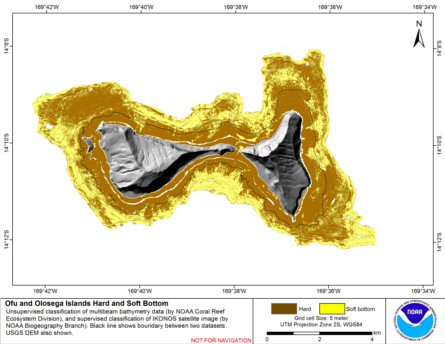
Hard and soft seafloor substrate map, derived from integrating
two existing map products: hard and soft seafloor substrate map
derived from an unsupervised classification of multibeam backscatter and
bathymetry derivatives, produced by NOAA Pacific Island...

CRED Optical Validation Data collected on Maui, Main Hawaiian Islands, USA, in 2014 to support Benthic Habitat Mapping
Optical validation data were collected using a Tethered Optical Assessment Device (TOAD), an underwater sled
equipped with an underwater digital video camera, digital still camera and lights, in the Kahekili coast area of western Maui island. Data were c...
Hawaii Coral Reef Assessment and Monitoring Program (CRAMP): Benthic Data from 1999-2001 (NODC Accession 0000969)
This dataset consists of CRAMP surveys taken in 1999-2001 and includes quantitative estimates of substrate type, species type, and percent coverage. Fish data are included in a separate submission. The types and coverages were derived objectively from ph...
CRED Optical Validation Data collected on Maui, Main Hawaiian Islands, USA, in 2015 to support Benthic Habitat Mapping
Optical validation data were collected using a Tethered Optical Assessment Device (TOAD), an underwater sled
equipped with an underwater digital video camera, digital still camera and lights, along the western Maui island coastline from Honolua Bay to Mal...
Pacific Reef Assessment and Monitoring Program: Calcification Rates of Crustose Coralline Algae Derived from Calcification Accretion Units (CAUs) Deployed across American Samoa and the Pacific Remote Island Areas in 2010

Calcification accretion units, or CAUs, are used to assess the current effects of changes in seawater carbonate chemistry on calcification and accretion rates of calcareous and fleshy algae in the Hawaiian and Mariana Archipelagos, American Samoa, and the...
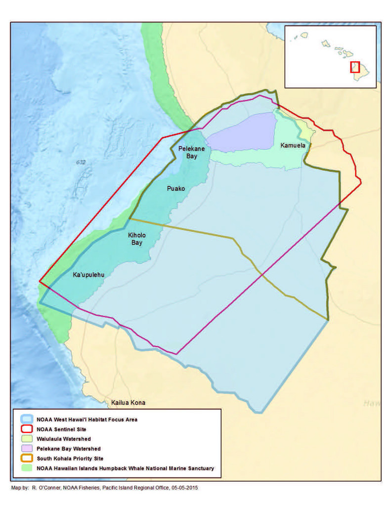 Benthic habitat maps depict dominant substrate type and biological cover in depths between 0 and ~150 m for two priority sites in the Main Hawaiian Islands; the NOAA Habitat Blueprint West Hawaii Focus Area (WHFA) and the Hawaii Division of Aquatic Resour...
 This data set contains a set of monthly and yearly global day-night sea surface temperature averages, derived from the AVHRR Pathfinder Version 5 sea surface temperature cloudscreened data set (http://pathfinder.nodc.noaa.gov) in GeoTIFF format. The AVHRR...
 Hard and soft seafloor substrate map, derived from integrating
two existing map products: hard and soft seafloor substrate map
derived from an unsupervised classification of multibeam backscatter and
bathymetry derivatives, produced by NOAA Pacific Island...
Hard and soft seafloor substrate map, derived from integrating
two existing map products: hard and soft seafloor substrate map
derived from an unsupervised classification of multibeam backscatter and
bathymetry derivatives, produced by NOAA Pacific Island...
 Calcification accretion units, or CAUs, are used to assess the current effects of changes in seawater carbonate chemistry on calcification and accretion rates of calcareous and fleshy algae in the Hawaiian and Mariana Archipelagos, American Samoa, and the...