
Integrated hard and soft bottom seafloor substrate map of Rose Atoll, American Samoa
combining NOAA Pacific Island Fisheries Science Center Coral Reef Ecosystem Division
hard-soft substrate maps with NOAA Center for Coastal Monitoring and Assessment Biogeography
Program shallow-water benthic habitat map of American Samoa.
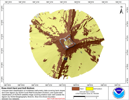
Hard and soft seafloor substrate map, derived from integrating two existing map
products: hard and soft substrate maps derived from an unsupervised classification of multibeam
backscatter and bathymetry derivatives, produced by NOAA Pacific Island Fisheri...
Integrated hard and soft bottom seafloor substrate map of Ofu-Olosega, American Samoa, combining
NOAA Pacific Island Fisheries Science Center Coral Reef Ecosystem Division
hard-soft substrate map with NOAA Center for Coastal Monitoring and Assessment
Biogeography Program shallow-water benthic habitat
map of American Samoa.
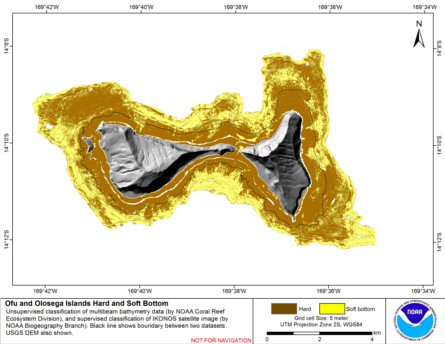
Hard and soft seafloor substrate map, derived from integrating
two existing map products: hard and soft seafloor substrate map
derived from an unsupervised classification of multibeam backscatter and
bathymetry derivatives, produced by NOAA Pacific Island...
Integrated hard and soft bottom seafloor substrate map of Ta'u, American Samoa, combining
NOAA Pacific Island Fisheries Science Center Coral Reef Ecosystem Division
hard-soft substrate map with NOAA Center for Coastal Monitoring and Assessment
Biogeography Program shallow-water benthic habitat
map of American Samoa.
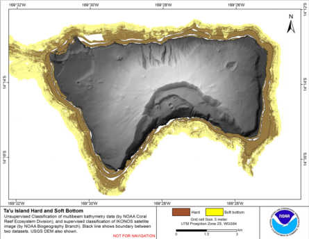
Hard and soft seafloor substrate map, derived from integrating
two existing map products: hard and soft seafloor substrate map
derived from an unsupervised classification of multibeam backscatter and
bathymetry derivatives, produced by NOAA Pacific Island...
Benthic Habitat Maps for Rose Atoll Marine National Monument in American Samoa from 2004 to 2010
Benthic habitat maps for Rose Atoll, American Samoa were derived from high resolution, multispectral satellite imagery for 2004, 2006, and 2010. The benthic habitat maps for 2004 were previously generated by NOAA's NCCOS's BioGeography Branch before this ...
Pacific Reef Assessment and Monitoring Program: Calcification Rates of Crustose Coralline Algae Derived from Calcification Accretion Units (CAUs) Deployed across American Samoa and the Pacific Remote Island Areas in 2010

Calcification accretion units, or CAUs, are used to assess the current effects of changes in seawater carbonate chemistry on calcification and accretion rates of calcareous and fleshy algae in the Hawaiian and Mariana Archipelagos, American Samoa, and the...
Eco-spatial data layers of coral reef ecosystem drivers in American Samoa
Understanding the spatial distribution, intensity, overlap, and cumulative impact of human activities and environmental stressors is essential for effective management and protection of ecosystem services generated by coral reefs. The data described here ...
Seafloor substrate (hard and soft bottom) maps at select islands/atolls in American Samoa, Mariana Archipelago, and the Pacific Remote Island Areas

Seafloor substrate (i.e., hard vs. soft bottom) from 0 to up to 50 m depths around islands/atolls in American Samoa, Mariana Archipelago, and Pacific Remote Island Areas produced by the NOAA Ecosystem Sciences Division (ESD). The islands/atolls include Tu...
Coral reef ecosystem marine protected area monitoring in Fagamalo, American Samoa: benthic images collected during belt transect surveys in 2015
In 2010 the village of Fagamalo, Tutuila, American Samoa, designated a no-take Marine Protected Area that sees the protection of 2.25 square kilometers of ocean. Because little is known regarding the status of living marine communities in the area, and at...

Benthic percent cover derived from image analysis for selected locations in the Pacific Ocean
The data products described herein are part of the NOAA Coral Reef Conservation Program (CRCP) funded projects aimed at documenting the status and trends for benthic cover and composition on coral reef ecosystems across the U.S. Pacific States and Territo...
 Hard and soft seafloor substrate map, derived from integrating two existing map
products: hard and soft substrate maps derived from an unsupervised classification of multibeam
backscatter and bathymetry derivatives, produced by NOAA Pacific Island Fisheri...
Hard and soft seafloor substrate map, derived from integrating two existing map
products: hard and soft substrate maps derived from an unsupervised classification of multibeam
backscatter and bathymetry derivatives, produced by NOAA Pacific Island Fisheri...
 Hard and soft seafloor substrate map, derived from integrating
two existing map products: hard and soft seafloor substrate map
derived from an unsupervised classification of multibeam backscatter and
bathymetry derivatives, produced by NOAA Pacific Island...
Hard and soft seafloor substrate map, derived from integrating
two existing map products: hard and soft seafloor substrate map
derived from an unsupervised classification of multibeam backscatter and
bathymetry derivatives, produced by NOAA Pacific Island...
 Calcification accretion units, or CAUs, are used to assess the current effects of changes in seawater carbonate chemistry on calcification and accretion rates of calcareous and fleshy algae in the Hawaiian and Mariana Archipelagos, American Samoa, and the...
 Seafloor substrate (i.e., hard vs. soft bottom) from 0 to up to 50 m depths around islands/atolls in American Samoa, Mariana Archipelago, and Pacific Remote Island Areas produced by the NOAA Ecosystem Sciences Division (ESD). The islands/atolls include Tu...