
Slope Grid Derived from Gridded Bathymetry for Select U.S. Coral Reef Locations across the Pacific Ocean
Slope is derived for islands and banks across the U.S. Pacific Islands Region primarily from gridded multibeam bathymetry collected aboard NOAA Ships Hi'ialakai and Oscar Elton Sette, and aboard R/V AHI (Acoustic Habitat Investigator) from 2003 to 2012 by...
Bathymetric Position Index (BPI) Zones Grid Derived from Gridded Bathymetry for Select U.S. Coral Reef Locations across the Pacific Ocean
Bathymetric Position Index (BPI) Zones are derived for islands and banks across the U.S. Pacific Islands Region from a focal mean analysis on bathymetry and slope, and were created using the Benthic Terrain Modeler. Cell values represent one of 4 classes ...
Bathymetric Position Index (BPI) Structures Grid Derived from Gridded Bathymetry for Select U.S. Coral Reef Locations across the Pacific Ocean
Bathymetric Position Index (BPI) Structures are derived for islands and banks across the U.S. Pacific Islands Region from a focal mean analysis on bathymetry and slope, and were created using the Benthic Terrain Modeler. Cell values represent one of 13 cl...
Rugosity Grid Derived from Gridded Bathymetry for Select U.S. Coral Reef Locations across the Pacific Ocean
Rugosity is derived for islands and banks across the U.S. Pacific Islands Region primarily from gridded multibeam bathymetry collected aboard NOAA Ships Hi'ialakai and Oscar Elton Sette, and aboard R/V AHI (Acoustic Habitat Investigator) from 2003 to 2012...
EM300 Multibeam Sonar Data collected from January 26 to April 22 from NOAA Ship Hi'ialakai cruise HA-15-01 to the Pacific Remote Island Areas and American Samoa in 2015
Multibeam data were collected using a Simrad EM300 30-kHz sonar aboard NOAA Ship Hi'ialakai, a 68-m (218') NOAA research vessel, from January 26 to April 22, 2015 during cruise HA-15-01. Multibeam data were acquired at Johnston, Howland, Baker, Jarvis, an...
Seafloor substrate (hard and soft bottom) maps at select islands/atolls in American Samoa, Mariana Archipelago, and the Pacific Remote Island Areas

Seafloor substrate (i.e., hard vs. soft bottom) from 0 to up to 50 m depths around islands/atolls in American Samoa, Mariana Archipelago, and Pacific Remote Island Areas produced by the NOAA Ecosystem Sciences Division (ESD). The islands/atolls include Tu...
 Gridded bathymetry at 40m resolution surrounding Baker Island, within the Pacific Remote Island Areas - Central Pacific Ocean. Bottom coverage was achieved in depths between 8 and 4700 meters. The Arc ASCII grids and floating point geotifs include multibe...
 Gridded bathymetry at 40m resolution surrounding Howland Island, within the Pacific Remote Island Areas - Central Pacific Ocean. Bottom coverage was achieved in depths between 8 and 3800 meters. The Arc ASCII grids and floating point geotifs include multi...
 Seafloor substrate (i.e., hard vs. soft bottom) from 0 to up to 50 m depths around islands/atolls in American Samoa, Mariana Archipelago, and Pacific Remote Island Areas produced by the NOAA Ecosystem Sciences Division (ESD). The islands/atolls include Tu...
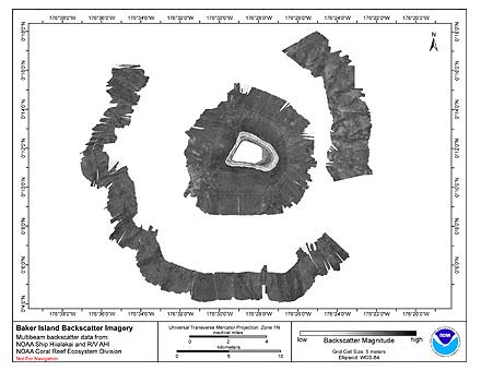 Multibeam backscatter imagery extracted from gridded bathymetry of the shelf and slope
environments of Baker Island, Pacific Island Areas, Central Pacific. These data provide coverage
between 8 and 4700 meters. The backscatter dataset includes data collec...
Multibeam backscatter imagery extracted from gridded bathymetry of the shelf and slope
environments of Baker Island, Pacific Island Areas, Central Pacific. These data provide coverage
between 8 and 4700 meters. The backscatter dataset includes data collec...