 Seafloor substrate (hard and soft bottom) maps at select islands/atolls in American Samoa, Mariana Archipelago, and the Pacific Remote Island Areas
 Seafloor substrate (i.e., hard vs. soft bottom) from 0 to up to 50 m depths around islands/atolls in American Samoa, Mariana Archipelago, and Pacific Remote Island Areas produced by the NOAA Ecosystem Sciences Division (ESD). The islands/atolls include Tu...
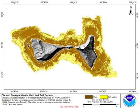 Hard and soft seafloor substrate map, derived from integrating
two existing map products: hard and soft seafloor substrate map
derived from an unsupervised classification of multibeam backscatter and
bathymetry derivatives, produced by NOAA Pacific Island...
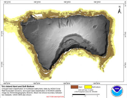
Hard and soft seafloor substrate map, derived from integrating
two existing map products: hard and soft seafloor substrate map
derived from an unsupervised classification of multibeam backscatter and
bathymetry derivatives, produced by NOAA Pacific Island...
 Hard and soft seafloor substrate map, derived from integrating
two existing map products: hard and soft seafloor substrate map
derived from an unsupervised classification of multibeam backscatter and
bathymetry derivatives, produced by NOAA Pacific Island...
Hard and soft seafloor substrate map, derived from integrating
two existing map products: hard and soft seafloor substrate map
derived from an unsupervised classification of multibeam backscatter and
bathymetry derivatives, produced by NOAA Pacific Island...
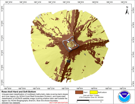 Hard and soft seafloor substrate map, derived from integrating two existing map
products: hard and soft substrate maps derived from an unsupervised classification of multibeam
backscatter and bathymetry derivatives, produced by NOAA Pacific Island Fisheri...
Hard and soft seafloor substrate map, derived from integrating two existing map
products: hard and soft substrate maps derived from an unsupervised classification of multibeam
backscatter and bathymetry derivatives, produced by NOAA Pacific Island Fisheri...
 Benthic percent cover derived from image analysis for selected locations in the Pacific Ocean