Water temperature data from reef sites off the upper Florida Keys from 2003-09-18 to 2022-12-11 (NCEI Accession 0126994)
Temperature loggers were deployed at various monitoring sites off the upper Florida Keys where other ecological studies were underway, most focused on aspects of Acropora spp. status or ecology. Hobo Tidbit® or Pendant® loggers were secured to the substra...
Gridded multibeam bathymetry of Guam Island, Guam U.S. Territory
Gridded bathymetry at 60m resolution surrounding Guam Island, Guam U.S. Territory. Bottom coverage was achieved in depths between 0 and ~3500 meters. The Arc ASCII grids and floating point geotifs include multibeam bathymetry data acquired over multiple s...
Bathymetric Position Index (BPI) Zones Grid Derived from Gridded Bathymetry for Select U.S. Coral Reef Locations across the Pacific Ocean
Bathymetric Position Index (BPI) Zones are derived for islands and banks across the U.S. Pacific Islands Region from a focal mean analysis on bathymetry and slope, and were created using the Benthic Terrain Modeler. Cell values represent one of 4 classes ...
Bathymetric Position Index (BPI) Structures Grid Derived from Gridded Bathymetry for Select U.S. Coral Reef Locations across the Pacific Ocean
Bathymetric Position Index (BPI) Structures are derived for islands and banks across the U.S. Pacific Islands Region from a focal mean analysis on bathymetry and slope, and were created using the Benthic Terrain Modeler. Cell values represent one of 13 cl...
Slope Grid Derived from Gridded Bathymetry for Select U.S. Coral Reef Locations across the Pacific Ocean
Slope is derived for islands and banks across the U.S. Pacific Islands Region primarily from gridded multibeam bathymetry collected aboard NOAA Ships Hi'ialakai and Oscar Elton Sette, and aboard R/V AHI (Acoustic Habitat Investigator) from 2003 to 2012 by...
Rugosity Grid Derived from Gridded Bathymetry for Select U.S. Coral Reef Locations across the Pacific Ocean
Rugosity is derived for islands and banks across the U.S. Pacific Islands Region primarily from gridded multibeam bathymetry collected aboard NOAA Ships Hi'ialakai and Oscar Elton Sette, and aboard R/V AHI (Acoustic Habitat Investigator) from 2003 to 2012...
EM300 Multibeam Sonar Data collected from May 7 to May 22 from NOAA Ship Hi'ialakai cruise HA-17-01 to the Commonwealth of Northern Mariana Islands (CNMI) and Guam in 2017
Multibeam data were collected using a Simrad EM300 30-kHz sonar aboard NOAA Ship Hi'ialakai, a 68-m (218') NOAA research vessel, from May 7 to May 22, 2017 during cruise HA-17-01. Multibeam data were acquired at Guam and Aguijan in the Marianas. The multi...
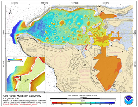
Gridded multibeam bathymetry of Apra Harbor, Guam U.S. Territory
Gridded bathymetry from Apra Harbor, Guam U.S. Territory. The netCDF and Arc
ASCII grids include multibeam bathymetry from the Reson SeaBat 8125 multibeam sonar
collected in 2008 by the NOAA Office of Coast Survey and the United States Navy Fleet
Survey T...
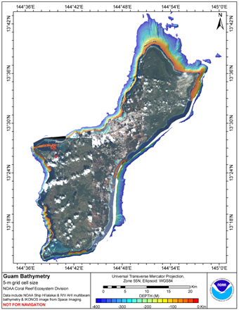
CRED 5m Gridded multibeam bathymetry of Guam Island, Guam U.S.
Territory
Gridded bathymetry shelf, bank and slope environments of
Guam Island, Guam U.S. Territory. Bottom coverage was achieved in
depths between 0 and -3532 meters but this 5-m grid only includes
coverage to -400 m depths. The netCDF and Arc ASCII grids
include...
Gridded multibeam bathymetry of Howland Island, Pacific Remote Island Areas, Central Pacific
Gridded bathymetry at 40m resolution surrounding Howland Island, within the Pacific Remote Island Areas - Central Pacific Ocean. Bottom coverage was achieved in depths between 8 and 3800 meters. The Arc ASCII grids and floating point geotifs include multi...
 Water temperature data from reef sites off the upper Florida Keys from 2003-09-18 to 2022-12-11 (NCEI Accession 0126994)
 Gridded bathymetry at 60m resolution surrounding Guam Island, Guam U.S. Territory. Bottom coverage was achieved in depths between 0 and ~3500 meters. The Arc ASCII grids and floating point geotifs include multibeam bathymetry data acquired over multiple s...
 Gridded bathymetry from Apra Harbor, Guam U.S. Territory. The netCDF and Arc
ASCII grids include multibeam bathymetry from the Reson SeaBat 8125 multibeam sonar
collected in 2008 by the NOAA Office of Coast Survey and the United States Navy Fleet
Survey T...
Gridded bathymetry from Apra Harbor, Guam U.S. Territory. The netCDF and Arc
ASCII grids include multibeam bathymetry from the Reson SeaBat 8125 multibeam sonar
collected in 2008 by the NOAA Office of Coast Survey and the United States Navy Fleet
Survey T...
 Gridded bathymetry shelf, bank and slope environments of
Guam Island, Guam U.S. Territory. Bottom coverage was achieved in
depths between 0 and -3532 meters but this 5-m grid only includes
coverage to -400 m depths. The netCDF and Arc ASCII grids
include...
Gridded bathymetry shelf, bank and slope environments of
Guam Island, Guam U.S. Territory. Bottom coverage was achieved in
depths between 0 and -3532 meters but this 5-m grid only includes
coverage to -400 m depths. The netCDF and Arc ASCII grids
include...
 Gridded bathymetry at 40m resolution surrounding Howland Island, within the Pacific Remote Island Areas - Central Pacific Ocean. Bottom coverage was achieved in depths between 8 and 3800 meters. The Arc ASCII grids and floating point geotifs include multi...