
Coral and artificial reef shape files, Broward County, Florida, (NODC Accession 0000244)
Coral reef and artificial reef location shape files and accompanying table files for reefs located off shore of Broward County, Florida. Accompanying "attribute" tables provide information on artificial reef type, date of creation, and associated informa...
2010 NOAA Ortho-rectified Mosaic from Color Aerial Imagery of Pensacola Bay, FL - FL0703 - Phase II - Pensacola Bay (NODC Accession 0074383)
Data set contains 2.5km by 2.5km digital orthophotography mosaics. The digital orthophotos in this series have a nominal ground resolution of 1 meter. The digital orthophoto mosaics are three band, 8-bit GeoTIFFs with pyramids and are color balanced to be...
NCCOS Mapping: Geospatial products of water depth, acoustic backscatter, and ROV data collected from NOAA Ship Nancy Foster in the Northeast Caribbean Sea in the off the coast of Guanica and Ponce, Puerto Rico from 2018-06-29 to 2018-06-07 (NCEI Accession 0276935)
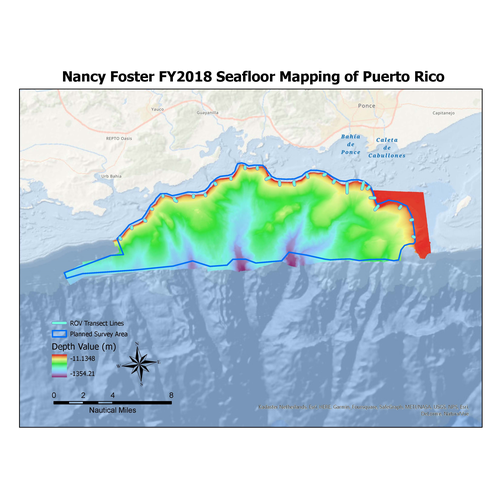
Multibeam and acoustic backscatter data collected from NOAA Ship Nancy Foster from 2018-06-29 to 2018-07-06. The majority of data were collected using a Kongsberg EM710, with the most northern inshore portion collected using a Kongsberg EM2040. Bathyme...
2015 NOAA NGS Topobathy Lidar: Dry Tortugas (FL)
These data were collected and derived by the National Oceanic Atmospheric Administration, National Geodetic Survey Remote Sensing Division using a Riegl VQ820G system. The data were acquired from 20150314- 20150323. The data includes topobathy data in a ...