Downloadable DataNCCOS Mapping: Geospatial products of water depth, acoustic backscatter, and ROV data collected from NOAA Ship Nancy Foster in the Northeast Caribbean Sea in the off the coast of Guanica and Ponce, Puerto Rico from 2018-06-29 to 2018-06-07 (NCEI Accession 0276935)
Metadata Thumbnail Multibeam and acoustic backscatter data collected from NOAA Ship Nancy Foster from 2018-06-29 to 2018-07-06. The majority of data were collected using a Kongsberg EM710, with the most northern inshore portion collected using a Kongsberg EM2040. Bathyme...
Downloadable DataNCCOS Assessment: Southeastern U.S. Predictive Modeling of Deep-Sea Corals and Hardbottom Habitats, 2016-10-01 to 2021-09-30 (NCEI Accession 0282806)
Metadata Thumbnail This data collection contains geospatial data from models predicting the spatial distributions of deep-sea corals (DSCs) and hardbottom habitats offshore of the southeastern U.S. It includes a database (.csv text file) containing records of occurrence (pr...
Geographic ServicesStacked species distribution models of deep-sea corals and sponges off the United States west coast (NCEI Accession 0303081)
Metadata Thumbnail These data are a set of raster maps of community-level predictions of deep-sea coral and sponge taxa distributions off the continental U.S. west coast, spanning depths from 50 to 1200 m. The raster files come in two versions: one where predicted distribut...
Downloadable DataBenthic Habitats of Buck Island Reef National Monument, St. Croix U.S. Virgin Islands, 2004-02-18 to 2011-08-30 (NCEI Accession 0285904)
Metadata Thumbnail This data package contains information about the geology and biology of the seafloor from approximately 0 to 1,830 meters in Buck Island Reef National Monument (BIRNM) St. Croix, U.S. Virgin Islands (USVI). It was created by delineating habitats visible i...
Downloadable DataNCCOS Mapping: Geospatial products of water depth, acoustic backscatter, and ROV data collected from NOAA Ship Nancy Foster in the Northeast Caribbean Sea surrounding St. Croix and St. Thomas, US. Virgin Islands from 2019-07-02 to 2019-07-12 (NCEI Accession 0276772)
Metadata Thumbnail 
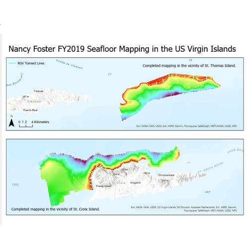
Multibeam and acoustic backscatter data collected from NOAA Ship Nancy Foster from 2019-07-02 to 2019-07-12. The majority of these data were collected using a Kongsberg EM710, with the most inshore portion collected using a Kongsberg EM2040. Bathymetry gr...
Downloadable DataNCCOS Mapping: Geospatial products of water depth, acoustic backscatter, and ROV data collected from NOAA Ship Nancy Foster in the US Caribbean off the coast of Northwest Puerto Rico from 2022-03-14 to 2022-03-31 (NCEI Accession 0279008)
Metadata Thumbnail Multibeam and acoustic backscatter data collected from NOAA Ship Nancy Foster from 2022-03-14 to 2022-03-31. The majority of these data were collected using a Kongsberg EM710, with the most inshore portion collected using a Kongsberg EM2040. Bathymetry...
Downloadable DataNCCOS Mapping: Geospatial products of water depth, acoustic backscatter, and ROV data collected from NOAA Ship Nancy Foster in the Dry Tortugas, Florida Keys National Marine Sanctuary from 2021-03-18 to 2021-04-10 (NCEI Accession 0290189)
Metadata Thumbnail Multibeam and acoustic backscatter data collected from NOAA Ship Nancy Foster from 2021-03-18 to 2021-04-10. Data was collected using a Kongsberg EM2040. Bathymetry grids were created using CARIS HIPS and SIPS software, and corrected to Mean Lower Low Wat...
Downloadable DataNCCOS Mapping: Merged Bathymetry Data in the Channel Islands National Marine Sanctuary for Benthic Habitat Mapping from 1998 to 2022 (NCEI Accession 0304093)
Metadata Thumbnail We created merged bathymetry surfaces segmented in GeoTIFF format by resolution and depth within the Channel Islands National Marine Sanctuary (CINMS) from more than 20 multibeam mapping surveys. These bathymetry data were collected between 1998 and 2022 ...
Downloadable DataNCCOS assessment: Predicting deep-sea coral habitats within the Papahānaumokuākea Marine National Monument, Hawaii (NCEI Accession 0244006)
Metadata Thumbnail This data collection contains geospatial data from spatial predictive models that were developed for 22 deep-sea coral and sponge (DSCS) taxa within the Papahānaumokuākea Marine National Monument (PMNM) from depths of 100–3,500 m. It includes raster datas...
Downloadable DataNCCOS spatial modeling of threatened Caribbean corals: presence-only modeling for threatened Orbicella species from the nearshore to the mesophotic from 2007-01-01 to 2018-12-31 (NCEI Accession 0241110)
Metadata Thumbnail This dataset is a compilation of modeled spatial distributions of Threatened corals, Orbicella annularis (lobed star coral) and Orbicella faveolata (mountainous star coral)/Orbicella franksi (boulder star coral). in the shallow and upper mesophotic waters...