
NCCOS Mapping: Geospatial products of water depth, acoustic backscatter, and ROV data collected from NOAA Ship Nancy Foster in the Northeast Caribbean Sea in the off the coast of Guanica and Ponce, Puerto Rico from 2018-06-29 to 2018-06-07 (NCEI Accession 0276935)
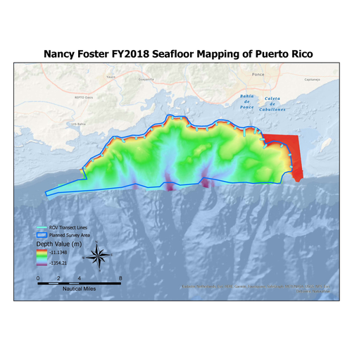
Multibeam and acoustic backscatter data collected from NOAA Ship Nancy Foster from 2018-06-29 to 2018-07-06. The majority of data were collected using a Kongsberg EM710, with the most northern inshore portion collected using a Kongsberg EM2040. Bathyme...
Benthic Habitats of Buck Island Reef National Monument, St. Croix U.S. Virgin Islands, 2004-02-18 to 2011-08-30 (NCEI Accession 0285904)
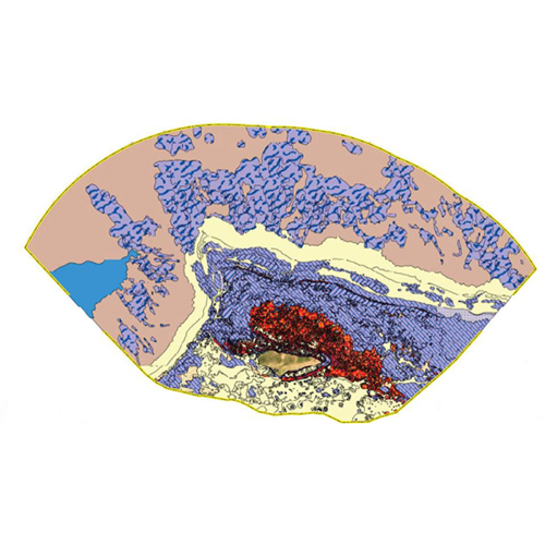
This data package contains information about the geology and biology of the seafloor from approximately 0 to 1,830 meters in Buck Island Reef National Monument (BIRNM) St. Croix, U.S. Virgin Islands (USVI). It was created by delineating habitats visible i...
NCCOS Mapping: Geospatial products of water depth, acoustic backscatter, and ROV data collected from NOAA Ship Nancy Foster in the US Caribbean off the coast of Northwest Puerto Rico from 2022-03-14 to 2022-03-31 (NCEI Accession 0279008)
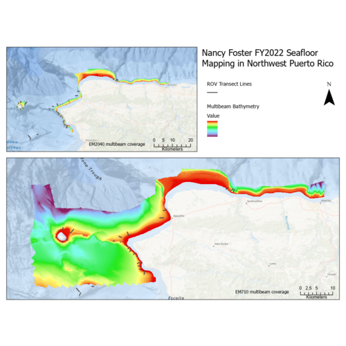
Multibeam and acoustic backscatter data collected from NOAA Ship Nancy Foster from 2022-03-14 to 2022-03-31. The majority of these data were collected using a Kongsberg EM710, with the most inshore portion collected using a Kongsberg EM2040. Bathymetry...
NCCOS Mapping: Geospatial products of water depth, acoustic backscatter, and ROV data collected from NOAA Ship Nancy Foster in the Northeast Caribbean Sea surrounding St. Croix and St. Thomas, US. Virgin Islands from 2019-07-02 to 2019-07-12 (NCEI Accession 0276772)
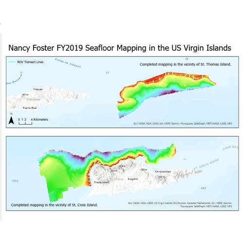
Multibeam and acoustic backscatter data collected from NOAA Ship Nancy Foster from 2019-07-02 to 2019-07-12. The majority of these data were collected using a Kongsberg EM710, with the most inshore portion collected using a Kongsberg EM2040. Bathymetry gr...
2015 NOAA NGS Topobathy Lidar: Dry Tortugas (FL)
These data were collected and derived by the National Oceanic Atmospheric Administration, National Geodetic Survey Remote Sensing Division using a Riegl VQ820G system. The data were acquired from 20150314- 20150323. The data includes topobathy data in a ...
Coral and artificial reef shape files, Broward County, Florida, (NODC Accession 0000244)
Coral reef and artificial reef location shape files and accompanying table files for reefs located off shore of Broward County, Florida. Accompanying "attribute" tables provide information on artificial reef type, date of creation, and associated informa...