
2018 USGS/NRCS Lidar DEM: Southeast Florida
Product: These are Digital Elevation Model (DEM) data for Florida counties of Broward, Collier, Hendry, Miami-Dade, Monroe, and Palm Beach, as part of the required deliverables for the Florida Southeast 2018 Lidar project. Class 2 (ground) lidar points in...
Gridded bathymetry of Galvez Bank, S. Galvez Bank, and 11-Mile Reef, Territory of Guam, USA
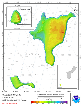
Gridded bathymetry (5m) of the bank environment of Galvez Bank, and 2 small nearby banks
S. Galvez Bank (~ 3 nmi south of Galvez) and 11-mile Reef (~ 5 nmi north of Galvez, 11 nmi west of Guam),
Territory of Guam, USA. These netCDF and ASCII grids include...
Gridded bathymetry of 35 fthm Bank, and 37 fthm Bank, north of Farallon de Medinilla, CNMI, USA.
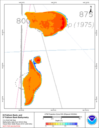
Gridded bathymetry (5m) of the bank environment of 35-fthm Bank
and 37 fthm Bank,CNMI USA. These netCDF and ASCII grids include multibeam bathymetry from the Reson 8101
multibeam sonar aboard the NOAA Ship Oscar E. Sette collected as of May 2010 by the NO...
Currents in Kaneohe Bay, Oahu, Hawaii 2005 - 2007 in Support of Fresh Water Plume Studies Performed by the Department of Oceanography
at the Univesity of Hawaii (NODC Accession 0040251)
Freshwater plumes from rain run-off into Kaneohe Bay is the
focus for the investigation. Measurements in this data set
are currents as measured by an moored Acoustic Doppler Current
Profiler (ADCP) and a Nortek current meter. Data were collected
during ...
 Product: 1-meter bare-earth raster digital elevation model (DEM) data tiles in GeoTIFF format.
Geographic Extent: Approximately 4,028 square miles encompassing the Big Island of Hawaii.
Dataset Description: The HI Hawaii Island Lidar NOAA 2017 B17 lidar p...
Product: 1-meter bare-earth raster digital elevation model (DEM) data tiles in GeoTIFF format.
Geographic Extent: Approximately 4,028 square miles encompassing the Big Island of Hawaii.
Dataset Description: The HI Hawaii Island Lidar NOAA 2017 B17 lidar p...
 Product: These are Digital Elevation Model (DEM) data for U.S. Virgin Islands as part of the required deliverables for the PR USVI 2018 Lidar project. Class 2 (ground) lidar points in conjunction with the hydro breaklines were used to create a 0.5 meter h...
 This data set was retrieved from the USGS rockyftp website and processed to NOAA/OCM's Digital Coast.
Product: These are Digital Elevation Model (DEM) data for Puerto Rico and its surround islands as part of the required deliverables for the PR USVI 201...
This data set was retrieved from the USGS rockyftp website and processed to NOAA/OCM's Digital Coast.
Product: These are Digital Elevation Model (DEM) data for Puerto Rico and its surround islands as part of the required deliverables for the PR USVI 201...
 Original Dataset Product: 0.5-meter bare-earth raster digital elevation model (DEM) data tiles in GeoTIFF format.
Original Dataset Geographic Extent:
HI_NOAAMauiOahu_3: The work unit covers approximately Approximately 306 square miles on the eastern s...
Original Dataset Product: 0.5-meter bare-earth raster digital elevation model (DEM) data tiles in GeoTIFF format.
Original Dataset Geographic Extent:
HI_NOAAMauiOahu_3: The work unit covers approximately Approximately 306 square miles on the eastern s...
 Original Dataset Product: 0.5-meter bare-earth raster digital elevation model (DEM) data tiles in GeoTIFF format.
Original Dataset Geographic Extent:
HI_NOAAMauiOahu_1: The work unit covers approximately 446 square miles (260.7 square miles of Molokai...
Original Dataset Product: 0.5-meter bare-earth raster digital elevation model (DEM) data tiles in GeoTIFF format.
Original Dataset Geographic Extent:
HI_NOAAMauiOahu_1: The work unit covers approximately 446 square miles (260.7 square miles of Molokai...