
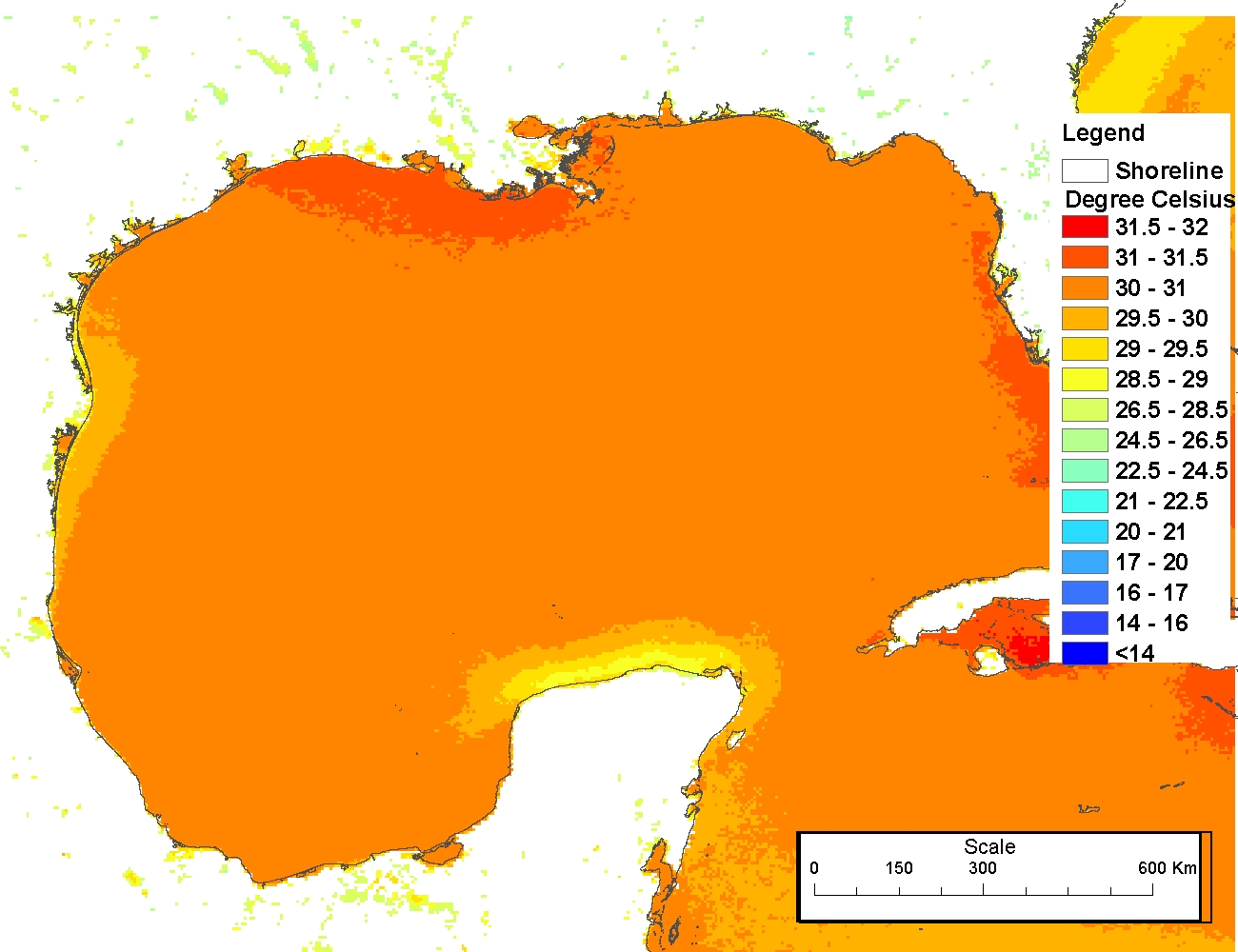
Sea surface temperatures from AVHRR
The production of these AVHRR L2P data is a NEODAAS activity in collaboration with the UK National Centre for Ocean Forecasting (NCOF). NEODAAS-Dundee acquires approx. 15 AVHRR HRPT passes per day over NW Europe and Arctic, each approx. 15 minutes duratio...

Landsat 7 ETM/1G satellite imagery - Hawaiian Islands cloud-free mosaics
Cloud-free Landsat satellite imagery mosaics of the islands of the main 8 Hawaiian Islands (Hawaii, Maui, Kahoolawe, Lanai, Molokai, Oahu, Kauai and Niihau). Landsat 7 ETM (enhanced thematic mapper) is a polar orbiting 8 band
multispectral satellite-borne...
NCCOS Assessment: Assessment of organic and inorganic chemical contaminants in the sediments of the Salt River Bay National Historical Park and Ecological Preserve, St. Croix, US Virgin Islands, 2018-09-04 to 2018-09-06 (NCEI Accession 0220105)

This dataset contains results from the analysis of sediments for chemical contaminants including organic contaminants like hydrocarbons and pesticides, and inorganic contaminants like metals, along with an assessment of the benthic infaunal community in S...
 This data set contains a set of monthly and yearly global day-night sea surface temperature averages, derived from the AVHRR Pathfinder Version 5 sea surface temperature cloudscreened data set (http://pathfinder.nodc.noaa.gov) in GeoTIFF format. The AVHRR...
 The mapped data derived from AVHRR is divided into files for CoastWatch regions of interest. Each file contains multiple data variables stored using the HDF-4 Scientific Data Sets (SDS) model. The product contents are channel 1 albedo, channel 2 albedo, c...
 The 4 km Pathfinder effort at the National Oceanic and Atmospheric Administration (NOAA) National Oceanographic Data Center (NODC) and the University of Miami's Rosenstiel School of Marine and Atmospheric Science (RSMAS) is an extension of and improvement...
 The 4 km Pathfinder effort at the National Oceanic and Atmospheric Administration (NOAA) National Oceanographic Data Center (NODC) and the University of Miami's Rosenstiel School of Marine and Atmospheric Science (RSMAS) is an extension of and improvement...
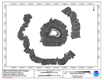 Multibeam backscatter imagery extracted from gridded bathymetry of the shelf and slope
environments of Baker Island, Pacific Island Areas, Central Pacific. These data provide coverage
between 8 and 4700 meters. The backscatter dataset includes data collec...
Multibeam backscatter imagery extracted from gridded bathymetry of the shelf and slope
environments of Baker Island, Pacific Island Areas, Central Pacific. These data provide coverage
between 8 and 4700 meters. The backscatter dataset includes data collec...