 National Coral Reef Monitoring Program: Water Temperature Data from Subsurface Temperature Recorders (STRs) deployed at coral reef sites across the Hawaiian Archipelago 2016-09-03 to 2024-08-25 (NCEI Accession 0300489)
Gridded bathymetry of Penguin Bank, Hawaii, USA
National Coral Reef Monitoring Program: Water Temperature Data from Subsurface Temperature Recorders (STRs) deployed at coral reef sites across the Hawaiian Archipelago 2016-09-03 to 2024-08-25 (NCEI Accession 0300489)
National Coral Reef Monitoring Program: Water Temperature Data from Subsurface Temperature Recorders (STRs) deployed at coral reef sites across the Hawaiian Archipelago 2016-09-03 to 2024-08-25 (NCEI Accession 0300489)
Gridded bathymetry of Penguin Bank, Hawaii, USA
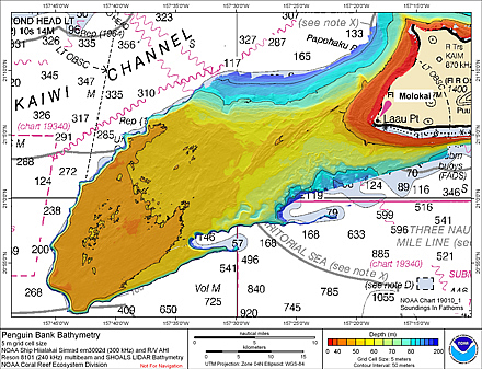 Gridded bathymetry (5 m cell size) of Penguin Bank, Hawaii, USA.
The netCDF grid and ArcGIS ASCII file include multibeam bathymetry from the Simrad
EM3002d, and Reson 8101 multibeam sonars collected during cruises in 2005 and 2006
by the NOAA Coral Reef E...
Gridded multibeam bathymetry and SHOALS LIDAR bathymetry of Penguin Bank, Hawaii, USA
Gridded bathymetry (5 m cell size) of Penguin Bank, Hawaii, USA.
The netCDF grid and ArcGIS ASCII file include multibeam bathymetry from the Simrad
EM3002d, and Reson 8101 multibeam sonars collected during cruises in 2005 and 2006
by the NOAA Coral Reef E...
CRED Simrad em120 multibeam backscatter data from portions of the banktop and bank edge environments at Maro Reef, Hawaii, USA with 30 meter resolution in Arc ASCII format
Gridded bathymetry (5 m cell size) of Penguin Bank, Hawaii, USA.
The netCDF grid and ArcGIS ASCII file include multibeam bathymetry from the Simrad
EM3002d, and Reson 8101 multibeam sonars collected during cruises in 2005 and 2006
by the NOAA Coral Reef E...
Gridded multibeam bathymetry and SHOALS LIDAR bathymetry of Penguin Bank, Hawaii, USA
Gridded bathymetry (5 m cell size) of Penguin Bank, Hawaii, USA.
The netCDF grid and ArcGIS ASCII file include multibeam bathymetry from the Simrad
EM3002d, and Reson 8101 multibeam sonars collected during cruises in 2005 and 2006
by the NOAA Coral Reef E...
CRED Simrad em120 multibeam backscatter data from portions of the banktop and bank edge environments at Maro Reef, Hawaii, USA with 30 meter resolution in Arc ASCII format
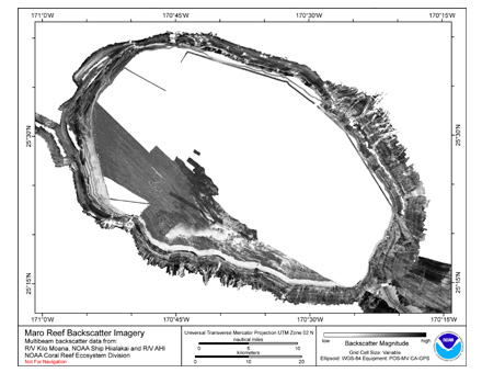 Multibeam backscatter imagery extracted from gridded bathymetry of Maro Reef, Northwestern Hawaiian Islands, USA.
These data provide coverage between 20 and 5000 meters. The backscatter dataset includes data collected using Simrad EM300, Simrad EM3002d,
S...
2018 Miami-Dade ITD Lidar: Miami-Dade County, FL
Multibeam backscatter imagery extracted from gridded bathymetry of Maro Reef, Northwestern Hawaiian Islands, USA.
These data provide coverage between 20 and 5000 meters. The backscatter dataset includes data collected using Simrad EM300, Simrad EM3002d,
S...
2018 Miami-Dade ITD Lidar: Miami-Dade County, FL
 GPI Geospatial Inc., operating under the authority of Miami-Dade County Aviation Department, as per contract number E15-MDAD-01, has been tasked by Miami Dade County's Information Technology Department (ITD) to provide LiDAR data for 615 square miles, inc...
American Samoa Watershed and Coastal Community Data Layers, Utulei, Fagaalu, Fatumafuti 2014
NOAA Coral Reef Watch Experimental Daily Light Stress Damage Product Suite for the Pacific Region
GPI Geospatial Inc., operating under the authority of Miami-Dade County Aviation Department, as per contract number E15-MDAD-01, has been tasked by Miami Dade County's Information Technology Department (ITD) to provide LiDAR data for 615 square miles, inc...
American Samoa Watershed and Coastal Community Data Layers, Utulei, Fagaalu, Fatumafuti 2014
NOAA Coral Reef Watch Experimental Daily Light Stress Damage Product Suite for the Pacific Region
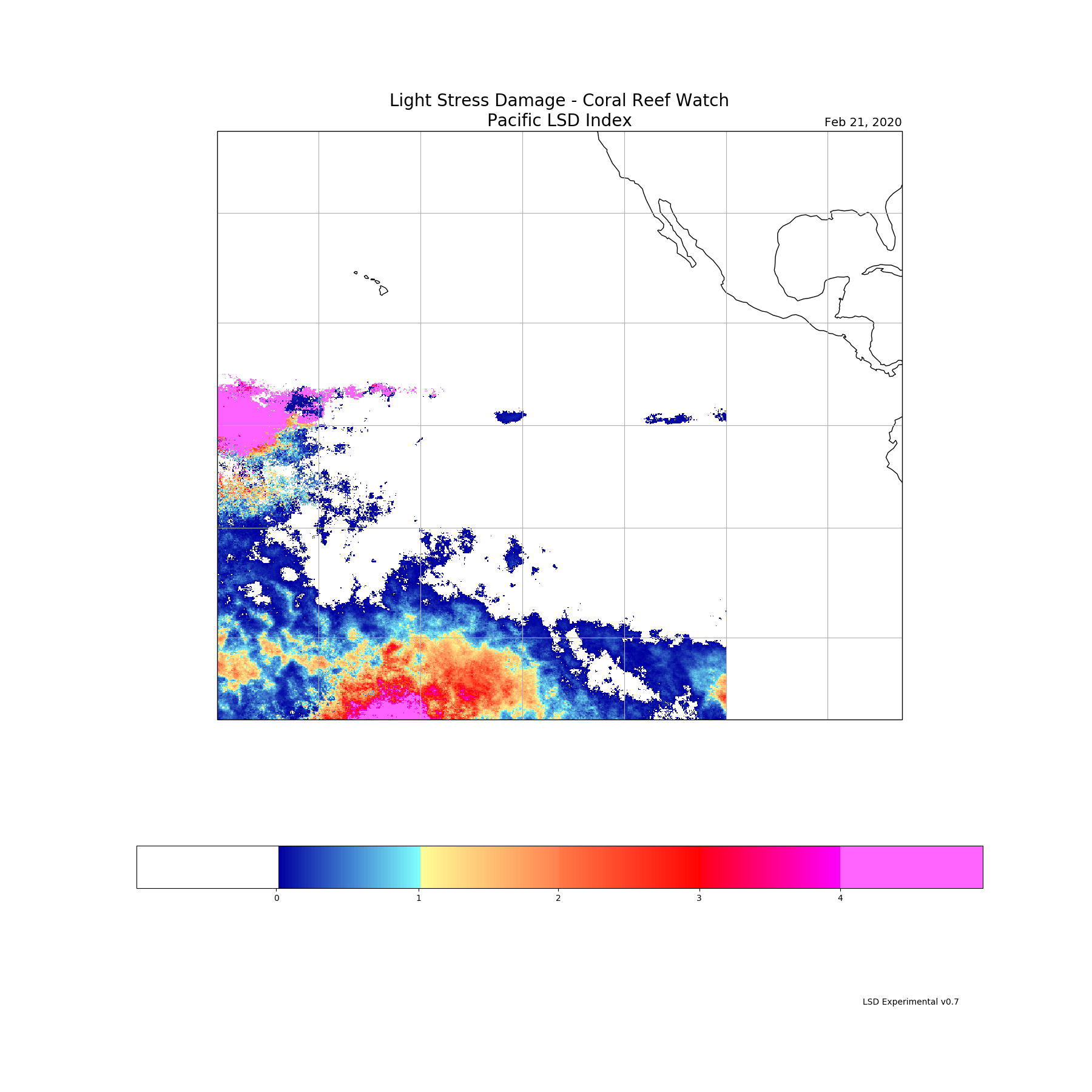 The NOAA Coral Reef Watch (CRW) Experimental Daily Light Stress Damage (LSD) Product Suite for the Pacific Region is part of CRWs near-real-time Decision Support System (DSS) for coral reef management, which includes CRWs Daily Global 5 km Satellite Cor...
NOAA Coral Reef Watch Experimental Daily Light Stress Damage Product Suite for the Caribbean Region
The NOAA Coral Reef Watch (CRW) Experimental Daily Light Stress Damage (LSD) Product Suite for the Pacific Region is part of CRWs near-real-time Decision Support System (DSS) for coral reef management, which includes CRWs Daily Global 5 km Satellite Cor...
NOAA Coral Reef Watch Experimental Daily Light Stress Damage Product Suite for the Caribbean Region
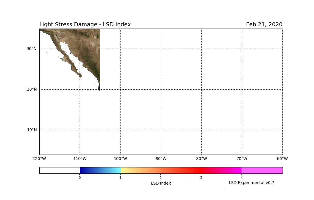 The NOAA Coral Reef Watch (CRW) Experimental Daily Light Stress Damage (LSD) Product Suite for the Caribbean Region is part of CRWs near-real-time Decision Support System (DSS) for coral reef management, which includes CRWs Daily Global 5 km Satellite C...
CRED Gridded Bathymetry of East Gardner Pinnacles (100-016) in the Northwestern Hawaiian Islands
CRED Gridded Bathymetry of French Frigate Shoals (100-019) in the Northwestern Hawaiian Islands
The NOAA Coral Reef Watch (CRW) Experimental Daily Light Stress Damage (LSD) Product Suite for the Caribbean Region is part of CRWs near-real-time Decision Support System (DSS) for coral reef management, which includes CRWs Daily Global 5 km Satellite C...
CRED Gridded Bathymetry of East Gardner Pinnacles (100-016) in the Northwestern Hawaiian Islands
CRED Gridded Bathymetry of French Frigate Shoals (100-019) in the Northwestern Hawaiian Islands