The West Maui Water Owner's Manual is a collection of recommendations for protecting for protecting and improving water quality and ocean resources in West Maui. The Owner Manual recommends actions for all the watershed's residents and users, and identifi...
Endangered Species Act (ESA) Section 7(a)(2) Biological Opinion and Magnuson-Stevens Fishery Conservation and Management Act Essential Fish Habitat (EFH) Response Impacts of the Role of the BIA Under its Authority to Assist with the Development of the 2020-2021 Puget Sound Chinook Harvest Plan, Salmon Fishing Activities Authorized by the U.S. Fish and Wildlife Service, and Fisheries Authorized by the U.S. Fraser Panel in 2020
Impacts of the Role of the BIA Under its Authority to Assist with the Development of the 2020-2021 Puget Sound Chinook Harvest Plan, Salmon Fishing Activities Authorized by the U.S. Fish and Wildlife Service, and Fisheries Authorized by the U.S. Fraser Pa...
Multibeam Mapping of the West Florida Shelf-The Edges, Gulf of Mexico, Appalachicola, Florida.
XYZ ASCII format high-resolution bathymetry data generated from the 2010 multibeam sonar survey of the West Florida Shelf-The Edges, Gulf of Mexico, Appalachicola, Florida.
Summary of Rain Garden Installation Clinic and additional retrofit reconnaissance
"This memorandum provides a brief summary of the March 15-16, 2013 Rain Garden Installation Clinic at the Lahaina Civic Center and the Wahikuli Wayside Park in West Maui. The purpose of the clinic was to: 1) initiate implementation of the 2012 Wahikuli-Ho...
Multibeam Mapping of Pulley Ridge, Gulf of Mexico, Key West, Florida
XYZ ASCII format high-resolution bathymetry data generated from the 2003, 2007, and 2009 combined multibeam sonar survey of Pulley Ridge, Gulf of Mexico, Key West, Florida.
"The Atlas of the Reefs of West Maui (Atlas) describes the region's coral reefs and their associated fishes based on surveys conducted across 23.6 miles of coastline, collected by numerous public and private organizations between 1999 and 2019. These data...
 West Maui watershed owner's manual
 Multibeam Mapping of the West Florida Shelf-The Edges, Gulf of Mexico, Appalachicola, Florida.
 CRED Cumulative Map of Percent Scleractinian Coral Cover at St. Rogatien West, 2001
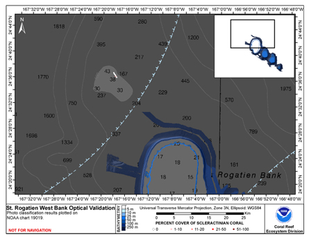 This map displays optical validation observation locations and percent coverage of scleractinian coral overlaid on bathymetry.