Determining Watershed Management Efficacy in West Maui: Belt transect surveys of coral demography (adult and juvenile corals) from 2014 to 2015
The focus of the Wahikuli-Honokowai Watershed Management Plan is the land use practices and alterations affected in the agricultural and urban districts that have upset the natural drainage patterns and ecohydrologic balance and services the watersheds pr...
Determining Watershed Management Efficacy in West Maui: line-point-intercept and photo quadrat surveys of benthic communities for benthic cover from 2014 to 2015
The focus of the Wahikuli-Honokowai Watershed Management Plan is the land use practices and alterations affected in the agricultural and urban districts that have upset the natural drainage patterns and ecohydrologic balance and services the watersheds pr...
Determining the efficacy of watershed management in the Wahikuli and Honokowai watersheds, West Maui
Purpose/need: The Hawaii Coral Reef Strategy identified the coral reef ecosystem along the West Maui watersheds (Ka’anapali to Honolua) as a State Priority Management Area. Coral reefs in the region are severely affected by sedimentation and siltation str...
Quantifying condition of coral reef communities in the Kahana and Honokahua Priority Watersheds, West Maui Project Information
"The Hawaii Coral Reef Strategy identified the coral reef ecosystem along the West Maui watersheds (Ka'anapali to Honolua) as a State Priority Management Area. Coral reefs in the region are severely affected by sedimentation and siltation stress, due to e...
Quantifying condition of coral reef communities in the Kahana and Honokahua Priority Watersheds, West Maui Project Information
The Hawaii Coral Reef Strategy identified the coral reef ecosystem along the West Maui watersheds (Ka’anapali to Honolua) as a State Priority Management Area. Coral reefs in the region are severely affected by sedimentation and siltation stress, due to ex...
"This initiative is an all-encompassing approach across multiple agencies, organizations, and jurisdictions to address adverse impacts to coral reefs in West Maui. The proposed 24,000-acre study area extends from Ka`anapali northward to Honolua and from t...
West Maui, Hawaii, Coastal Uses Participatory Mapping Project, 2011
The West Maui Coastal use Participatory Mapping Project was developed through a partnership between the Hawaii State Division of Aquatic Resources (HDAR), NOAA's Pacific Islands Regional Office (PIRO), NOAA Coral Reef Conservation Program (CRCP) and NOAA'...
Quantifying condition of coral reef communities in the Kahana and Honokahua Priority Watersheds, West Maui.
2017 UPDATE: This project will address continue data collection in the W Maui area that have been the center of CRCP-supported monitoring efforts. Last year's project "FY16 Quantifying condition of coral reef communities in the Kahana and Honokahua Priori...
Delineate, Designate, and Demonstrate Stream Riparian Buffers in Wahikuli, West Maui
"West Maui has been designated a priority conservation site by state and federal governments in an effort to address land-based pollution and corresponding declines in coral cover. Several West Maui Watershed plans identify erosion from degraded agricultu...
Determining the effectiveness of watershed management activities to reduce land-based pollution on West Maui
"As an approach to reduce the effects of land-based sources of pollution on coral reefs, the U.S. Coral Reef Task Force and NOAA's Coral Reef Conservation Program identified West Maui as one of two Pacific Region priority areas for the implementation of t...
 Determining Watershed Management Efficacy in West Maui: Belt transect surveys of coral demography (adult and juvenile corals) from 2014 to 2015
 The focus of the Wahikuli-Honokowai Watershed Management Plan is the land use practices and alterations affected in the agricultural and urban districts that have upset the natural drainage patterns and ecohydrologic balance and services the watersheds pr...
 Determining the efficacy of watershed management in the Wahikuli and Honokowai watersheds, West Maui
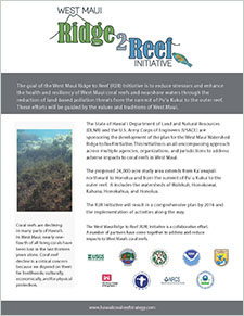 "This initiative is an all-encompassing approach across multiple agencies, organizations, and jurisdictions to address adverse impacts to coral reefs in West Maui. The proposed 24,000-acre study area extends from Ka`anapali northward to Honolua and from t...