Hawaii Coral Reef Assessment and Monitoring Program (CRAMP): digital still images from transects on Kauai, Oahu, Molokai, Maui, and Hawaii 2011-2012 (NODC Accession 0119360)
This dataset consists of digital still images from the Hawaii Coral Reef Assessment and Monitoring Program (CRAMP) taken 2011-2012 from 29 sites within 5 main Hawaiian Islands (Kauai, Oahu, Molokai, Maui, and Hawaii). During 2011, only sites on Maui were ...
Hawaii Coral Reef Assessment and Monitoring Program (CRAMP): benthic data from digital still images made in 2011-2012 on Kauai, Oahu, Molokai, Maui, and Hawaii (NODC Accession 0117490)
This dataset consists of benthic data from the Hawaii Coral Reef Assessment and Monitoring Program (CRAMP) taken 2011-2012 from 29 sites within 5 main Hawaiian Islands (Kauai, Oahu, Molokai, Maui, and Hawaii). During 2011, only sites on Maui were surveyed...
Hawaii Coral Reef Assessment and Monitoring Program (CRAMP): digital still images from transects on Kauai, Oahu, Molokai, Maui, and Hawaii 2008-2010 (NODC Accession 0104357)
This dataset consists of digital still images from the Hawaii Coral Reef Assessment and Monitoring Program (CRAMP) taken 2008-2010 from 24 sites within 5 main Hawaiian Islands (Kauai, Oahu, Molokai, Maui, and Hawaii). Most sites consist of two transects a...
2007 JALBTCX Hawaii Lidar: North Coasts of Hawaii (Big Island), Kauai, Maui, Molokai, Oahu
The data contained in these files contain topographic data collected by the CHARTS system along the northern coast of Hawaii (Big Island), Kauai, Maui, Molokai, and Oahu in the state of Hawaii. The data were collected on the following dates:
Hawaii (Big I...
Cruise report, NOAA Ship Hi'ialakai, Cruise HI-06-10, July 27-August 20, 2006 , Main Hawaiian Islands (Oahu, Kauai, Niihau, Kaula Rock, Lehua Rock, Molokai, Maui, Lanai, and Hawaii)
Personnel from the Coral Reef Ecosystem Division, Pacific Islands Fisheries Science Center (PIFSC), National Marine Fisheries Service (NMFS), National Oceanic and Atmospheric Administration (NOAA) and the Division of Aquatic Resources of the Hawaii Depart...
Benthic Surveys for Ground Truthing of Coastal Benthic Mapping in the Main Eight Hawaiian Islands 2001-2002 (NODC Accession 0001329)
The National Oceanic and Atmospheric Administration (NOAA) National Ocean Service (NOS) initiated a coral reef research program in 1999 to map, assess, inventory, and monitor U.S. coral reef ecosystems. These activities were implemented in response to req...
Cloud-free Landsat satellite imagery mosaics of the islands of the main 8 Hawaiian Islands (Hawaii, Maui, Kahoolawe, Lanai, Molokai, Oahu, Kauai and Niihau). Landsat 7 ETM (enhanced thematic mapper) is a polar orbiting 8 band
multispectral satellite-borne...
Hawaii Coral Reef Assessment and Monitoring Program (CRAMP): Benthic Data from Digital Still Images made in 2007 on Maui, Molokai, and Kauai (NODC Accession 0051060)
This dataset consists of CRAMP surveys taken in 2007 from 9 sites on
Maui, 3 sites on Molokai, and 1 site on Kauai. Sites typical have
two transects along different isobaths, shallow (~3m) and deep (~10m) lines.
Quantitative estimates of substrate type a...
The FEMA Task Order 26 LiDAR data set was collected by Airborne 1 Corporation of El Segundo, California in September - December of 2006 for URS Corp.
Original contact information:
Contact Org: Dewberry
Phone: 703.849.0100
 Hawaii Coral Reef Assessment and Monitoring Program (CRAMP): digital still images from transects on Kauai, Oahu, Molokai, Maui, and Hawaii 2011-2012 (NODC Accession 0119360)
 Cruise report, NOAA Ship Hi'ialakai, Cruise HI-06-10, July 27-August 20, 2006 , Main Hawaiian Islands (Oahu, Kauai, Niihau, Kaula Rock, Lehua Rock, Molokai, Maui, Lanai, and Hawaii)
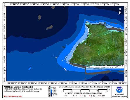 This map displays optical validation observation locations and percent coverage of scleractinian coral
overlaid on bathymetry.
This map displays optical validation observation locations and percent coverage of scleractinian coral
overlaid on bathymetry.