
Sampling grids to support the collection and analysis of survey data for the National Coral Reef Monitoring Program in American Samoa, Pacific Remote Islands Areas, Main Hawaiian Islands
The sampling grids are identified as essential components for the stratified random sampling design of the National Coral Reef Monitoring Program (NCRMP). The benthic habitat map layers including bathymetry, hard and soft substrates, reef zones and sector...
Seafloor substrate (hard and soft bottom) maps at select islands/atolls in American Samoa, Mariana Archipelago, and the Pacific Remote Island Areas

Seafloor substrate (i.e., hard vs. soft bottom) from 0 to up to 50 m depths around islands/atolls in American Samoa, Mariana Archipelago, and Pacific Remote Island Areas produced by the NOAA Ecosystem Sciences Division (ESD). The islands/atolls include Tu...
EM300 Multibeam Sonar Data collected from January 26 to April 22 from NOAA Ship Hi'ialakai cruise HA-15-01 to the Pacific Remote Island Areas and American Samoa in 2015
Multibeam data were collected using a Simrad EM300 30-kHz sonar aboard NOAA Ship Hi'ialakai, a 68-m (218') NOAA research vessel, from January 26 to April 22, 2015 during cruise HA-15-01. Multibeam data were acquired at Johnston, Howland, Baker, Jarvis, an...
Satellite-derived bathymetry for nearshore benthic habitats in the Pacific Remote Islands Marine National Monument
Bathymetric data derived from multispectral, high-resolution (2 m) satellite imagery acquired between 2011 and 2016 from Digital Globe’s WorldView-2 or WorldView-3 satellite to provide near complete coverage of nearshore terrain around several islands and...
 Seafloor substrate (i.e., hard vs. soft bottom) from 0 to up to 50 m depths around islands/atolls in American Samoa, Mariana Archipelago, and Pacific Remote Island Areas produced by the NOAA Ecosystem Sciences Division (ESD). The islands/atolls include Tu...
 Fishery Ecosystem Plan for the Pacific Remote Island Areas
 Gridded (5 m cell size) bathymetry of the shelf and slope environments
of Baker Island, Pacific Remote Island Areas, Central Pacific.
Almost complete bottom coverage was achieved in depths between
8 and 4700 meters (5 m grid includes data to 300 m). The b...
Gridded (5 m cell size) bathymetry of the shelf and slope environments
of Baker Island, Pacific Remote Island Areas, Central Pacific.
Almost complete bottom coverage was achieved in depths between
8 and 4700 meters (5 m grid includes data to 300 m). The b...
 Gridded (5 m cell size) bathymetry of the shelf and slope environments
of Howland Island, Pacific Remote Island Areas, Central Pacific.
Almost complete bottom coverage was achieved in depths between 8 and
3800 meters (5 m grid includes depths to 300 m). T...
Gridded (5 m cell size) bathymetry of the shelf and slope environments
of Howland Island, Pacific Remote Island Areas, Central Pacific.
Almost complete bottom coverage was achieved in depths between 8 and
3800 meters (5 m grid includes depths to 300 m). T...
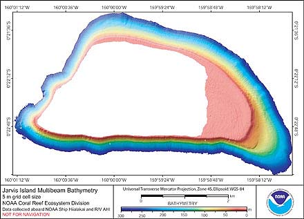 Gridded (5 m cell size) bathymetry of the shelf and slope environments
of Jarvis Island, Pacific Remote Island Areas, Central Pacific.
Almost complete bottom coverage was achieved in depths between
3 and 3600 meters (5 m grid includes data to 300 m). The ...
Gridded (5 m cell size) bathymetry of the shelf and slope environments
of Jarvis Island, Pacific Remote Island Areas, Central Pacific.
Almost complete bottom coverage was achieved in depths between
3 and 3600 meters (5 m grid includes data to 300 m). The ...