
Seafloor substrate (hard and soft bottom) maps at select islands/atolls in American Samoa, Mariana Archipelago, and the Pacific Remote Island Areas

Seafloor substrate (i.e., hard vs. soft bottom) from 0 to up to 50 m depths around islands/atolls in American Samoa, Mariana Archipelago, and Pacific Remote Island Areas produced by the NOAA Ecosystem Sciences Division (ESD). The islands/atolls include Tu...
National Coral Reef Monitoring Program: Shallow Water Conductivity-Temperature-Depth (CTD) Profiles for selected locations across Phoenix (Baker, Howland and Johnston) and Line (Jarvis, Kingman, Palmyra) Islands in the Pacific Remote Islands Marine National Monument from 2015-01-26 to 2015-04-28 (NCEI Accession 0162247)
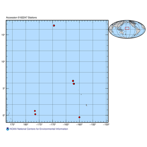
The data described here result from near-shore shallow water Conductivity-Temperature-Depth (CTD) casts conducted at select sites around the Pacific Remote Islands Marine National Monument as part of the ongoing National Coral Reef Monitoring Program (NCR...
National Coral Reef Monitoring Program: Shallow Water Conductivity-Temperature-Depth (CTD) Profiles for selected locations across Phoenix (Baker and Howland) and Line (Jarvis, Kingman, Palmyra) Islands in the Pacific Remote Islands Marine National Monument from 2018-06-08 to 2018-08-12 (NCEI Accession 0227441)
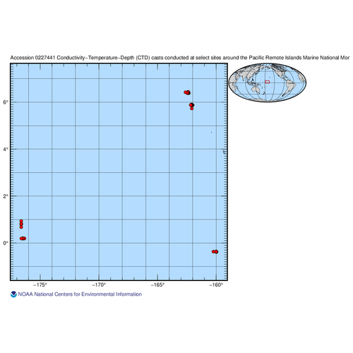
The data described here result from near-shore shallow water Conductivity-Temperature-Depth (CTD) casts conducted at select sites around the Pacific Remote Islands Marine National Monument as part of the ongoing National Coral Reef Monitoring Program (NCR...
NOAA CRED Shallow CTD Profiles 2011-2012 from the American Samoa and Pacific Reef and Assessment Monitoring Programs on NOAA Ship Hi'ialakai (NCEI Accession 0107470)
The Coral Reef Ecosystem Division of the Pacific Islands Fisheries Science Center, part of the National Marine Fisheries Service, National Oceanic and Atmospheric Administration (NOAA), conducted 126 shallow CTD profiling casts near Pacific islands, atoll...

Inshore Fishes of Howland Island, Baker Island, Jarvis Island, Palmyra Atoll, and Kingman Reef
"A list is given of shore fishes known from Howland and Baker Islands, outliers of the Phoenix Islands group, and Jarvis Island, Palmyra Atoll, and Kingman Reef in the Line Islands group. The list was compiled from literature sources, museum collection da...
EM300 Multibeam Sonar Data collected from January 26 to April 22 from NOAA Ship Hi'ialakai cruise HA-15-01 to the Pacific Remote Island Areas and American Samoa in 2015
Multibeam data were collected using a Simrad EM300 30-kHz sonar aboard NOAA Ship Hi'ialakai, a 68-m (218') NOAA research vessel, from January 26 to April 22, 2015 during cruise HA-15-01. Multibeam data were acquired at Johnston, Howland, Baker, Jarvis, an...
Sampling grids to support the collection and analysis of survey data for the National Coral Reef Monitoring Program in American Samoa, Pacific Remote Islands Areas, Main Hawaiian Islands
The sampling grids are identified as essential components for the stratified random sampling design of the National Coral Reef Monitoring Program (NCRMP). The benthic habitat map layers including bathymetry, hard and soft substrates, reef zones and sector...
Pacific Reef Assessment and Monitoring Program: Calcification Rates of Crustose Coralline Algae Derived from Calcification Accretion Units (CAUs) Deployed across American Samoa and the Pacific Remote Island Areas in 2010

Calcification accretion units, or CAUs, are used to assess the current effects of changes in seawater carbonate chemistry on calcification and accretion rates of calcareous and fleshy algae in the Hawaiian and Mariana Archipelagos, American Samoa, and the...
 Seafloor substrate (i.e., hard vs. soft bottom) from 0 to up to 50 m depths around islands/atolls in American Samoa, Mariana Archipelago, and Pacific Remote Island Areas produced by the NOAA Ecosystem Sciences Division (ESD). The islands/atolls include Tu...
 Calcification accretion units, or CAUs, are used to assess the current effects of changes in seawater carbonate chemistry on calcification and accretion rates of calcareous and fleshy algae in the Hawaiian and Mariana Archipelagos, American Samoa, and the...
 Assessing and monitoring cryptic reef diversity of colonizing marine invertebrates across the U.S.-affiliated islands and atolls in the Pacific since 2008 using the Autonomous Reef Monitoring Structure (ARMS) method
 To support a long-term program for sustainable management and conservation of coral reef ecosystems, from 2008, Autonomous Reef Monitoring Structures (ARMS) have been deployed and/or recovered across the U.S. Such cruises are conducted at two to three yea...