 Fishery Ecosystem Plan for the Pacific Remote Island Areas
This Pacific Remote Island Areas Fishery Ecosystem Plan (FEP) was developed by the Western Pacific Regional Fishery Management Council and represents the first step in an incremental and collaborative approach to implement ecosystem approaches to fishery ...
 Seafloor substrate (hard and soft bottom) maps at select islands/atolls in American Samoa, Mariana Archipelago, and the Pacific Remote Island Areas
 Seafloor substrate (i.e., hard vs. soft bottom) from 0 to up to 50 m depths around islands/atolls in American Samoa, Mariana Archipelago, and Pacific Remote Island Areas produced by the NOAA Ecosystem Sciences Division (ESD). The islands/atolls include Tu...
 This map displays optical validation observation locations and percent coverage of scleractinian coral
overlaid on bathymetry.
This map displays optical validation observation locations and percent coverage of scleractinian coral
overlaid on bathymetry.
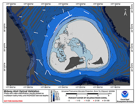
 This map displays optical validation observation locations and percent coverage of scleractinian coral overlaid on bathymetry.
 This map displays optical validation observation locations and percent coverage of scleractinian coral overlaid on bathymetry.