
National Coral Reef Monitoring Program: Benthic images collected from stratified random sites (StRS) across Baker, Howland, and Jarvis Islands, and Wake Atoll in the Pacific Remote Island Areas from 2017-04-02 to 2017-04-23 (NCEI Accession 0176288)
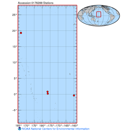
The data described here are benthic habitat imagery that result from benthic photo-quadrat surveys conducted along transects at stratified random sites across Baker, Howland, and Jarvis Islands, and Wake Atoll of the Pacific Remote Island Areas in April 2...
Seafloor substrate (hard and soft bottom) maps at select islands/atolls in American Samoa, Mariana Archipelago, and the Pacific Remote Island Areas

Seafloor substrate (i.e., hard vs. soft bottom) from 0 to up to 50 m depths around islands/atolls in American Samoa, Mariana Archipelago, and Pacific Remote Island Areas produced by the NOAA Ecosystem Sciences Division (ESD). The islands/atolls include Tu...
National Coral Reef Monitoring Program: Shallow Water Conductivity-Temperature-Depth (CTD) Profiles for selected locations across Phoenix (Baker, Howland and Johnston) and Line (Jarvis, Kingman, Palmyra) Islands in the Pacific Remote Islands Marine National Monument from 2015-01-26 to 2015-04-28 (NCEI Accession 0162247)
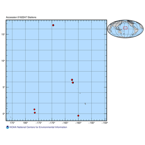
The data described here result from near-shore shallow water Conductivity-Temperature-Depth (CTD) casts conducted at select sites around the Pacific Remote Islands Marine National Monument as part of the ongoing National Coral Reef Monitoring Program (NCR...
EM300 Multibeam Sonar Data collected from January 26 to April 22 from NOAA Ship Hi'ialakai cruise HA-15-01 to the Pacific Remote Island Areas and American Samoa in 2015
Multibeam data were collected using a Simrad EM300 30-kHz sonar aboard NOAA Ship Hi'ialakai, a 68-m (218') NOAA research vessel, from January 26 to April 22, 2015 during cruise HA-15-01. Multibeam data were acquired at Johnston, Howland, Baker, Jarvis, an...

Coral reef condition: A status report for the Pacific Remote Islands
Healthy coral reefs are among the most biologically diverse, culturally significant, and economically valuable ecosystems on Earth. They are nursery grounds for fish and other organisms, provide food and jobs for people, and protect coasts against erosion...
FBSAD RECRUIT Reef Fish Belt Transect Survey at Hawaii Island (Big Island), Main Hawaiian Islands, 2008; and Midway Atoll, Northwestern Hawaiian Islands (NWHI), 2008 (NODC Accession 0067519)
Shore-based belt transects were conducted at 1 to ~ 5 m depths at a total four (4) sites: at (1-2) 2 longshore sites on the leeward coast (South Kohala district) of the Big Island (Hawaii Island) in the MHI during spring-summer 2008; and (3-4) at 2 longsh...
FBSAD PREDATOR Reef Fish Belt Transect Survey at Hawaii Island (Big Island), Main Hawaiian Islands, 2008; and Midway Atoll, Northwestern Hawaiian Islands (NWHI), 2008 (NODC Accession 0067519)
Shore-based belt transects were conducted at 1 to ~5 m depths at a total four (4) sites: at (1-2) 2 longshore sites on the leeward coast (South Kohala district) of the Big Island (Hawaii Island) in the MHI during spring-summer 2008; and (3-4) 2 longshore ...
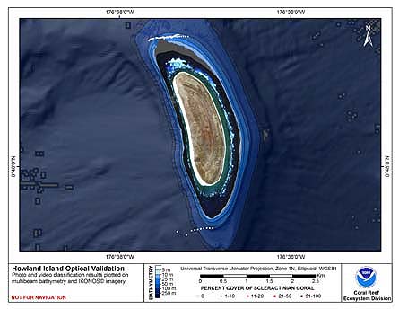
 This map displays optical validation observation locations and percent coverage of scleractinian coral overlaid on bathymetry.
 Seafloor substrate (i.e., hard vs. soft bottom) from 0 to up to 50 m depths around islands/atolls in American Samoa, Mariana Archipelago, and Pacific Remote Island Areas produced by the NOAA Ecosystem Sciences Division (ESD). The islands/atolls include Tu...
 This map displays optical validation observation locations and percent coverage of scleractinian coral overlaid on bathymetry.