CRED REA Line Point Intercept Surveys of Benthic Parameter Assessments at Wake Island, Pacific Remote Island Areas in 2005
To support a long-term NOAA Coral Reef Conservation Program (CRCP) for sustainable management and conservation of coral reef ecosystems, from 12 October - 30 October 2005, line point intercept (LPI) surveys of benthic parameter assessments were conducted,...
CRED REA Line Point Intercept Surveys of Benthic Parameter Assessments at Wake Island, Pacific Remote Island Areas in 2007
To support a long-term NOAA Coral Reef Conservation Program (CRCP) for sustainable management and conservation of coral reef ecosystems, from 19 April - 9 May 2007, line point intercept (LPI) surveys of benthic parameter assessments were conducted, as a p...
CRED REA Line Point Intercept Surveys of Benthic Parameter Assessments at Wake Island, Pacific Remote Island Areas in 2009
To support a long-term NOAA Coral Reef Conservation Program (CRCP) for sustainable management and conservation of coral reef ecosystems, from 12 March - 1 April 2009, line point intercept (LPI) surveys of benthic parameter assessments were conducted, as a...
CRED REA Reef Fish Assessment Survey at Wake Island, Pacific Remote Island Areas in 2009
To support a long-term NOAA Coral Reef Conservation Program (CRCP) for sustainable management and conservation of coral reef ecosystems, from 12 March - 1 April 2009, reef fish assessment surveys were conducted, as a part of Rapid Ecological Assessments (...
CRED Towed-Diver Fish Biomass Surveys at Wake Island, Pacific Remote Island Areas in 2005
Towed-diver surveys (aka. Towboard surveys) are conducted by the Coral Reef Ecosystem Division (CRED) of the NOAA Pacific Islands Fisheries Science Center (PIFSC) as part of biennial Pacific Reef Assessment and Monitoring Program (RAMP) Cruises. These cr...
CRED Towed-Diver Fish Biomass Surveys at Wake Island, Pacific Remote Island Areas in 2007
Towed-diver surveys (aka. Towboard surveys) are conducted by the Coral Reef Ecosystem Division (CRED) of the NOAA Pacific Islands Fisheries Science Center (PIFSC) as part of biennial Pacific Reef Assessment and Monitoring Program (RAMP) Cruises. These cr...
CRED Towed-Diver Fish Biomass Surveys at Wake Island, Pacific Remote Island Areas in 2009
Towed-diver surveys (aka. Towboard surveys) are conducted by the Coral Reef Ecosystem Division (CRED) of the NOAA Pacific Islands Fisheries Science Center (PIFSC) as part of biennial Pacific Reef Assessment and Monitoring Program (RAMP) Cruises. These cr...
CRED 60 m Gridded multibeam bathymetry of Wake Island, West Central Pacific
Gridded bathymetry shelf, bank and slope environments
of Wake Island, West Central Pacific, under joint management
of the United States Dept. of Interior and Air Force. Bottom
coverage was achieved in depths between 0 and -3828 meter.
The netCDF and Arc A...
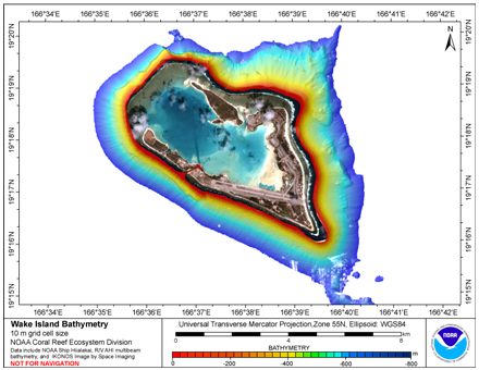
CRED 10 m Gridded multibeam bathymetry of Wake Island, West Central Pacific
Gridded bathymetry shelf, bank and slope environments of
Wake Island, West Central Pacific, under joint management of the
United States Dept. of Interior and Air Force. Bottom coverage
was achieved in depths between 0 and 3828 meter, though this
10 m grid...
CRED Towed-Diver Fish Biomass Survey at Wake, Pacific Remote
Island Areas in 2011
To support NOAA Coral Reef Conservation Program (CRCP) long-term
goals for sustainable management and conservation of coral reef
ecosystems, towed-diver surveys (AKA towboard surveys) are
conducted by the Co...
 CRED REA Line Point Intercept Surveys of Benthic Parameter Assessments at Wake Island, Pacific Remote Island Areas in 2005
 CRED 60 m Gridded multibeam bathymetry of Wake Island, West Central Pacific
 Gridded bathymetry shelf, bank and slope environments
of Wake Island, West Central Pacific, under joint management
of the United States Dept. of Interior and Air Force. Bottom
coverage was achieved in depths between 0 and -3828 meter.
The netCDF and Arc A...
Gridded bathymetry shelf, bank and slope environments
of Wake Island, West Central Pacific, under joint management
of the United States Dept. of Interior and Air Force. Bottom
coverage was achieved in depths between 0 and -3828 meter.
The netCDF and Arc A...
 Gridded bathymetry shelf, bank and slope environments of
Wake Island, West Central Pacific, under joint management of the
United States Dept. of Interior and Air Force. Bottom coverage
was achieved in depths between 0 and 3828 meter, though this
10 m grid...
Gridded bathymetry shelf, bank and slope environments of
Wake Island, West Central Pacific, under joint management of the
United States Dept. of Interior and Air Force. Bottom coverage
was achieved in depths between 0 and 3828 meter, though this
10 m grid...