Cruise report, NOAA Ship Oscar Elton Sette, Cruise 05-10 (OES-32) and Cruise 05-11 (OES-33), Marianas Archipelago: (Saipan, Guguan, Pagan, Asuncion, Uracas, Maug, Supply Reef, Agrihan, Alamagan, Zelandia Bank, Sarigan, Anatahan, Pathfinder, Arakane, Tinian, Aguijan, and Rota)
Personnel from the Coral Reef Ecosystem Division (CRED), Pacific Island Fisheries Science Center (PIFSC), National Marine Fisheries Service (NMFS), NOAA, conducted coral reef assessment/monitoring and mapping studies in waters surrounding the Commonwealth...
 Pacific Reef Assessment and Monitoring Program: Rapid Ecological Assessment Quadrat Surveys of Corals around the Marianas Islands from 2003 to 2007
 The Pacific Reef Assessment and Monitoring Program (Pacific RAMP), established by the Coral Reef Ecosystem Program (CREP) of the NOAA Pacific Islands Fisheries Science Center (PIFSC), is tasked with documenting and understanding the status and trends of c...
 Cruise report, NOAA Ship Oscar Elton Sette, Cruise 05-10 (OES-32) and Cruise 05-11 (OES-33), Marianas Archipelago: (Saipan, Guguan, Pagan, Asuncion, Uracas, Maug, Supply Reef, Agrihan, Alamagan, Zelandia Bank, Sarigan, Anatahan, Pathfinder, Arakane, Tinian, Aguijan, and Rota)
 Benthic percent cover derived from image analysis for selected locations in the Pacific Ocean
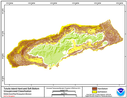
 Seafloor substrate (i.e., hard vs. soft bottom) from 0 to up to 50 m depths around islands/atolls in American Samoa, Mariana Archipelago, and Pacific Remote Island Areas produced by the NOAA Ecosystem Sciences Division (ESD). The islands/atolls include Tu...