Benthic data for corals, macroalgae, invertebrates, and non-living bottom types from Fagatele Bay, Pago Pago, and Fagasa, American Samoa, 2004-2008. (NODC Accession 0066319)
This data set was derived from surveys in Fagatele Bay National Marine Sanctuary, Pago Pago (Rainmaker and Aua), and Fagasa (Sita Bay and Cape Larsen) conducted in 2004 and 2007-2008. Parameters include coral, algal, or invertebrate species, coral colony...
NCCOS Assessment: Water Quality Data to Assess Eutrophication Effects on Coral Ecosystem Health in Vatia Bay, American Samoa from 2015-05-13 to 2018-08-28 (NCEI Accession 0208020)
This dataset represents three years of water quality data collected in Vatia Bay, American Samoa. A standard suite of nutrient parameters (nitrate, nitrite, ammonium, urea, total nitrogen, orthophosphate, total phosphorus and silica), as well as tracers o...
NCCOS Assessment: Chemical contaminants data from the Faga’alu Bay and Watershed, American Samoa before and after best management practices from 2014-01-18 to 2022-04-06 (NCEI Accession 0302885)
This dataset represents a “before and after” sediment sampling effort from Faga’alu Bay and watershed, American Samoa, to evaluate the effectiveness of best management practices at a quarry site. A suite of organic and inorganic parameters was quantified...
Benthic data for corals, macroalgae, invertebrates, and non-living bottom types from 12 sites in American Samoa, 2005-2009. (NODC Accession 0068364)
Benthic transects were repeated at 12 sites around Tutuila at various depths on the reef slopes and flats. Benthic coverage categories include coral species, invertebrates, and non-living substrate type. Annual surveys took place during 2005-2009. The ...
Summer 2004 Coral Bleaching Event on Tutuila, American Samoa (NODC Accession 0001955)
American Samoa's coral reefs have been impacted by a variety of major events, including periodic severe hurricanes, the most recent of which was Hurricane Heta, which was closest on Jan 6, 2004. Other events have included a Crown-of-Thorns seastar outbrea...
Reef Fish Surveys for Fagatele Bay, American Samoa, 2007 (NODC Accession 0068717)
Fish surveys were conducted in November 2007 using visual census techniques at Fagatele Bay under the guidance of Dr. Alison Green, the Nature Conservancy. This data set was collected at Transect 2, Fagatele Bay, in collaboration with surveys of NODC Acc...
Coastal activities in American Samoa in 2012 for use in coastal management
The American Samoa Coastal use Participatory Mapping Project was developed through a partnership between the American Samoa Government's Department of Commerce Coastal Management Program (ASCMP), Department of Marine and Wildlife Resources (DMWR), NOAA's ...
Coral Reef Surveys at 21 Sites in American Samoa during 2002 (NODC Accession 0000735)
Transects of the coral colonies at 21 sites in American Samoa were surveyed by Dr. Charles Birkeland during an underwater swim in March 2002. Data for each coral species include abundance and size distribution of the colonies. The living coral cover can...
Coral Reef Surveys at 21 Sites in American Samoa during 2002 (NODC Accession 0000622)
Transects of the coral colonies at 21 sites in American Samoa were surveyed by Dr. Charles Birkeland during an underwater swim in March 2002. Data for each coral species include abundance and size distribution of the colonies. The living coral cover can...
 Benthic data for corals, macroalgae, invertebrates, and non-living bottom types from Fagatele Bay, Pago Pago, and Fagasa, American Samoa, 2004-2008. (NODC Accession 0066319)
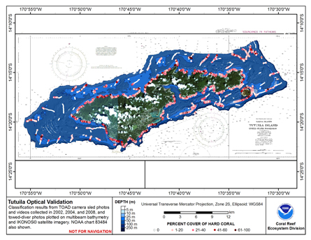 This map displays optical validation observation locations and percent coverage of hard coral overlaid on bathymetry.