 Satellite-derived bathymetry for nearshore benthic habitats in the Pacific Remote Islands Marine National Monument
Bathymetric data derived from multispectral, high-resolution (2 m) satellite imagery acquired between 2011 and 2016 from Digital Globe’s WorldView-2 or WorldView-3 satellite to provide near complete coverage of nearshore terrain around several islands and...
 Depth derivation using multispectral WorldView-2 satellite imagery
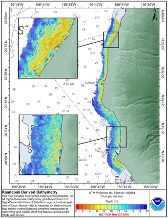 Methods used were adapted from a "cookbook" of instructions developed by Kyle Hogref
for using IKONOS imagery data to derive seafloor elevations in optically clear
water. This dataset was derived from high-resolution (2 m) imagery from DigitalGlobe's
Worl...
Methods used were adapted from a "cookbook" of instructions developed by Kyle Hogref
for using IKONOS imagery data to derive seafloor elevations in optically clear
water. This dataset was derived from high-resolution (2 m) imagery from DigitalGlobe's
Worl...
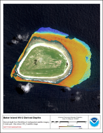 Bathymetric data derived from a multipectral World View-2 satellite
image mosaiced to provide near complete coverage of nearshore
terrain around the islands. Bathymetry values shallower than ~20 m were
derived by gauging the reletive attenuation of coasta...
Bathymetric data derived from a multipectral World View-2 satellite
image mosaiced to provide near complete coverage of nearshore
terrain around the islands. Bathymetry values shallower than ~20 m were
derived by gauging the reletive attenuation of coasta...
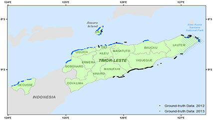 This dataset contains singlebeam bathymetry data acquired during small-boat surveys conducted from October 20-26, 2012 and June 4-27, 2013 in Timor-Leste by the NOAA Coral Reef Ecosystem Program (CREP). Data was acquired with a HydroLite-TM Echosounder Ki...
 Seafloor substrate (i.e., hard vs. soft bottom) from 0 to up to 50 m depths around islands/atolls in American Samoa, Mariana Archipelago, and Pacific Remote Island Areas produced by the NOAA Ecosystem Sciences Division (ESD). The islands/atolls include Tu...
 CRED REA Fish Team Belt Transect Survey at Kauai, Main Hawaiian Islands, 2006
 Bathymetric data derived from a multipectral World View-2 satellite
image mosaiced to provide near complete coverage of nearshore
terrain around the islands. Bathymetry values shallower than ~20 m were
derived by gauging the reletive attenuation of coasta...
Bathymetric data derived from a multipectral World View-2 satellite
image mosaiced to provide near complete coverage of nearshore
terrain around the islands. Bathymetry values shallower than ~20 m were
derived by gauging the reletive attenuation of coasta...