 Benthic habitat map for West Flower Garden Bank
The design of this field mission is three fold: (1) to spatially characterize the distribution, abundance and size of both reef fishes and macro invertebrates within and around the waters of the Flower Gardens National Marine Sanctuary using, (2) to relat...
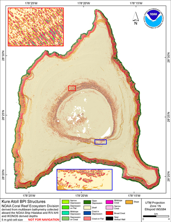
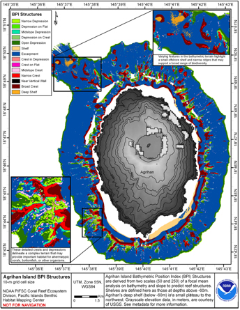 BPI Structures are derived from two scales of a focal mean
analysis on bathymetry and slope. The grid is based on
gridded (10 m cell size) multibeam bathymetry, collected aboard NOAA
Ship Hi'ialakai and R/V AHI, and it was created using the Benthic
Terrai...
BPI Structures are derived from two scales of a focal mean
analysis on bathymetry and slope. The grid is based on
gridded (10 m cell size) multibeam bathymetry, collected aboard NOAA
Ship Hi'ialakai and R/V AHI, and it was created using the Benthic
Terrai...
 BPI Structures are derived from a focal mean analysis on bathymetry and slope.
The bathymetry grid (5 m cell size) is derived from bathymetry from four sources:
Multibeam bathymetry collected by Coral Reef Ecosystem Division aboard NOAA R/V AHI, and
NOAA ...
BPI Structures are derived from a focal mean analysis on bathymetry and slope.
The bathymetry grid (5 m cell size) is derived from bathymetry from four sources:
Multibeam bathymetry collected by Coral Reef Ecosystem Division aboard NOAA R/V AHI, and
NOAA ...
 BPI Structures are derived from a focal mean analysis on bathymetry and slope.
The bathymetry grid (5 m cell size) is derived from two sources:
Multibeam bathymetry collected by Coral Reef Ecosystem Division aboard NOAA R/V AHI, and
NOAA Ship Hi'ialakai; ...
BPI Structures are derived from a focal mean analysis on bathymetry and slope.
The bathymetry grid (5 m cell size) is derived from two sources:
Multibeam bathymetry collected by Coral Reef Ecosystem Division aboard NOAA R/V AHI, and
NOAA Ship Hi'ialakai; ...
 This data set (Project Number OPR-I305-KRL-06) depicts depth values (mean 5 meter gridded) collected using LiDAR
(Light Detection & Ranging) from the shoreline of southwestern Puerto Rico to the shelf edge. The Tenix LADS Corporation
(TLI) acquired bathym...
This data set (Project Number OPR-I305-KRL-06) depicts depth values (mean 5 meter gridded) collected using LiDAR
(Light Detection & Ranging) from the shoreline of southwestern Puerto Rico to the shelf edge. The Tenix LADS Corporation
(TLI) acquired bathym...
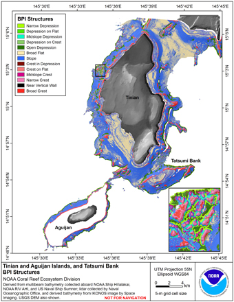 BPI Structures are derived from a focal mean analysis on bathymetry and slope.
The bathymetry grid (5 m cell size) is derived from bathymetry from three sources:
Multibeam bathymetry collected by Coral Reef Ecosystem Division aboard NOAA R/V AHI, and
NOAA...
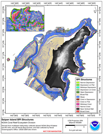
BPI Structures are derived from a focal mean analysis on bathymetry and slope.
The bathymetry grid (5 m cell size) is derived from bathymetry from three sources:
Multibeam bathymetry collected by Coral Reef Ecosystem Division aboard NOAA R/V AHI, and
NOAA...
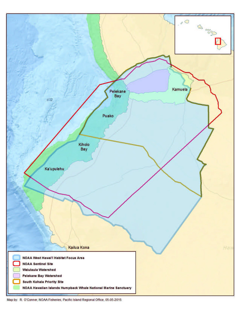 Hard and soft bottom seafloor substrate data and maps for the NOAA Habitat Blueprint West Hawaii Focus Area (WHFA) in the Main Hawaiian Islands. Cell values in the raster datasets reflect whether the seafloor is hard bottom or soft bottom based on an unsu...
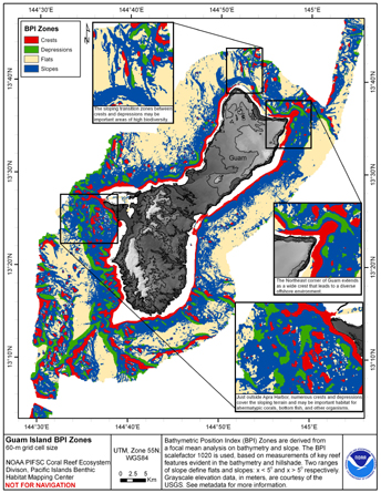 BPI Zones are derived from a focal mean
analysis on bathymetry and slope. The grid is based on
gridded (60 m cell size) multibeam bathymetry, collected aboard NOAA
Ship Hi'ialakai and R/V AHI, and it was created using the Benthic
Terrain Modeler (http://w...
BPI Zones are derived from a focal mean
analysis on bathymetry and slope. The grid is based on
gridded (60 m cell size) multibeam bathymetry, collected aboard NOAA
Ship Hi'ialakai and R/V AHI, and it was created using the Benthic
Terrain Modeler (http://w...
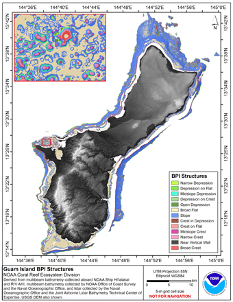
 BPI Structures are derived from two scales of a focal mean
analysis on bathymetry and slope. The grid is based on
gridded (5 m cell size) multibeam bathymetry, collected aboard R/V AHI
merged with seafloor depths derived from IKONOS satellite imagery. BP...
BPI Structures are derived from two scales of a focal mean
analysis on bathymetry and slope. The grid is based on
gridded (5 m cell size) multibeam bathymetry, collected aboard R/V AHI
merged with seafloor depths derived from IKONOS satellite imagery. BP...