 Gridded multibeam bathymetry of Guam Island, Guam U.S. Territory
 Gridded bathymetry at 60m resolution surrounding Guam Island, Guam U.S. Territory. Bottom coverage was achieved in depths between 0 and ~3500 meters. The Arc ASCII grids and floating point geotifs include multibeam bathymetry data acquired over multiple s...
 Gridded bathymetry at 40m resolution surrounding Baker Island, within the Pacific Remote Island Areas - Central Pacific Ocean. Bottom coverage was achieved in depths between 8 and 4700 meters. The Arc ASCII grids and floating point geotifs include multibe...
 Gridded bathymetry at 40m resolution surrounding Howland Island, within the Pacific Remote Island Areas - Central Pacific Ocean. Bottom coverage was achieved in depths between 8 and 3800 meters. The Arc ASCII grids and floating point geotifs include multi...
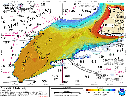 Gridded bathymetry (5 m cell size) of Penguin Bank, Hawaii, USA.
The netCDF grid and ArcGIS ASCII file include multibeam bathymetry from the Simrad
EM3002d, and Reson 8101 multibeam sonars collected during cruises in 2005 and 2006
by the NOAA Coral Reef E...
Gridded bathymetry (5 m cell size) of Penguin Bank, Hawaii, USA.
The netCDF grid and ArcGIS ASCII file include multibeam bathymetry from the Simrad
EM3002d, and Reson 8101 multibeam sonars collected during cruises in 2005 and 2006
by the NOAA Coral Reef E...
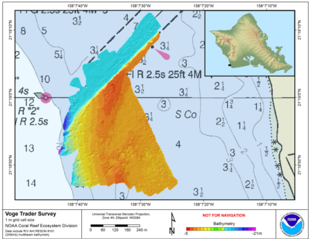 Gridded bathymetry (1m) of Barbers Point ship grounding site, Oahu, Hawaii, USA. The data include multibeam bathymetry from the Reson 8101 multibeam sonar collected in February, 2014 by the NOAA Coral Reef Ecosystem Division in depths between ~ 5 and 24 m...
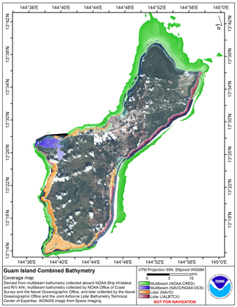 Gridded multibeam bathymetry is integrated with gridded lidar bathymetry.
Gridded (5 m cell size) multibeam bathymetry were collected aboard NOAA Ship
Hiialaka'i and R/V AHI and by the Naval Oceanographic Office and NOAA
Office of Coast Survey in Apra Har...
Gridded multibeam bathymetry is integrated with gridded lidar bathymetry.
Gridded (5 m cell size) multibeam bathymetry were collected aboard NOAA Ship
Hiialaka'i and R/V AHI and by the Naval Oceanographic Office and NOAA
Office of Coast Survey in Apra Har...
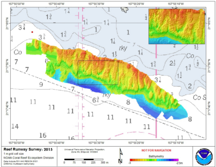 Gridded bathymetry (1m) of Reef Runway ship grounding site, Oahu, Hawaii, USA. The data include multibeam bathymetry from the Reson 8101 multibeam sonar collected in April, 2015 by the NOAA Coral Reef Ecosystem Division in depths between ~ 3.5 and 12.5 me...
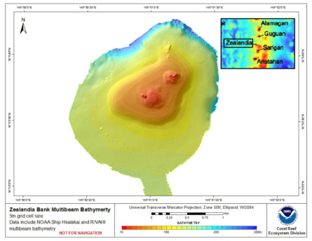 Gridded bathymetry shelf, bank and slope environments of
Zealandia Bank, CNMI. Bottom coverage was achieved in depths
between ~12 and 285 meters, The Arc ASCII grid includes multibeam
bathymetry from the Simrad EM300 and Reson 8101 multibeam sonars
collec...
Gridded bathymetry shelf, bank and slope environments of
Zealandia Bank, CNMI. Bottom coverage was achieved in depths
between ~12 and 285 meters, The Arc ASCII grid includes multibeam
bathymetry from the Simrad EM300 and Reson 8101 multibeam sonars
collec...
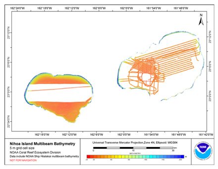 Gridded bathymetry (5m) of the shelf environment of Nihoa Island, Hawaii, USA.
This netCDF grid includes multibeam bathymetry from the Simrad EM120, Simrad EM1002,
Simrad EM300, and Simrad EM3002d multibeam sonars collected as of December 2006 by
the NOA...
Gridded bathymetry (5m) of the shelf environment of Nihoa Island, Hawaii, USA.
This netCDF grid includes multibeam bathymetry from the Simrad EM120, Simrad EM1002,
Simrad EM300, and Simrad EM3002d multibeam sonars collected as of December 2006 by
the NOA...