 Bathymetric Position Index (BPI) Zones Grid Derived from Gridded Bathymetry for Select U.S. Coral Reef Locations across the Pacific Ocean
Bathymetric Position Index (BPI) Zones are derived for islands and banks across the U.S. Pacific Islands Region from a focal mean analysis on bathymetry and slope, and were created using the Benthic Terrain Modeler. Cell values represent one of 4 classes ...
 BPI Structures are derived from two scales of a focal mean
analysis on bathymetry and slope. The grid is based on
gridded (20 m cell size) multibeam bathymetry, collected aboard R/V AHI
and NOAA ship Hi'ialakai. BPI Structures was created using the Benth...
BPI Structures are derived from two scales of a focal mean
analysis on bathymetry and slope. The grid is based on
gridded (20 m cell size) multibeam bathymetry, collected aboard R/V AHI
and NOAA ship Hi'ialakai. BPI Structures was created using the Benth...
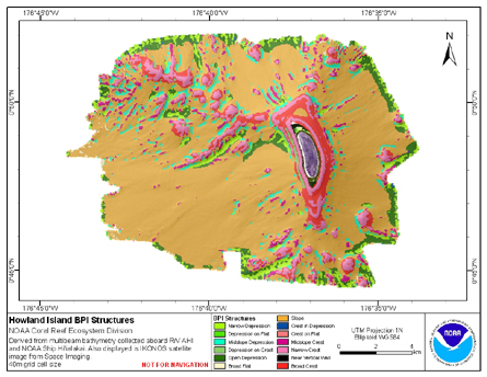 BPI Structures are derived from two scales of a focal mean
analysis on bathymetry and slope. The grid is based on
gridded (40 m cell size) multibeam bathymetry, collected aboard R/V AHI
and NOAA ship Hi'ialakai. BPI Structures was created using the Benth...
BPI Structures are derived from two scales of a focal mean
analysis on bathymetry and slope. The grid is based on
gridded (40 m cell size) multibeam bathymetry, collected aboard R/V AHI
and NOAA ship Hi'ialakai. BPI Structures was created using the Benth...
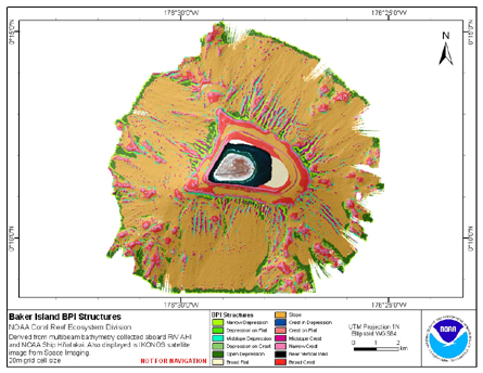
 BPI Structures are derived from two scales of a focal mean
analysis on bathymetry and slope. The grid is based on
gridded (20 m cell size) multibeam bathymetry, collected aboard R/V AHI
and NOAA ship Hi'ialakai. BPI Structures was created using the Benth...
BPI Structures are derived from two scales of a focal mean
analysis on bathymetry and slope. The grid is based on
gridded (20 m cell size) multibeam bathymetry, collected aboard R/V AHI
and NOAA ship Hi'ialakai. BPI Structures was created using the Benth...
 BPI Zones are derived from gridded (40 m cell size) multibeam
bathymetry, collected aboard R/V AHI and NOAA ship Hi'ialakai.
BPI Zones was created using the Benthic Terrain Modeler (http://www.csc.noaa.gov/products/btm/).
Cell values represent one of 4 cl...
BPI Zones are derived from gridded (40 m cell size) multibeam
bathymetry, collected aboard R/V AHI and NOAA ship Hi'ialakai.
BPI Zones was created using the Benthic Terrain Modeler (http://www.csc.noaa.gov/products/btm/).
Cell values represent one of 4 cl...
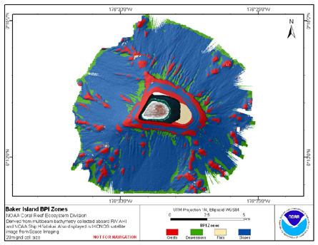
 BPI Zones are derived from gridded (20 m cell size) multibeam
bathymetry, collected aboard R/V AHI and NOAA ship Hi'ialakai.
BPI Zones was created using the Benthic Terrain Modeler (http://www.csc.noaa.gov/products/btm/).
Cell values represent one of 4 cl...
BPI Zones are derived from gridded (20 m cell size) multibeam
bathymetry, collected aboard R/V AHI and NOAA ship Hi'ialakai.
BPI Zones was created using the Benthic Terrain Modeler (http://www.csc.noaa.gov/products/btm/).
Cell values represent one of 4 cl...
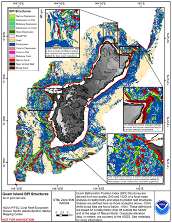 BPI Structures are derived from two scales of a focal mean
analysis on bathymetry and slope. The grid is based on
gridded (60 m cell size) multibeam bathymetry, collected aboard NOAA
Ship Hi'ialakai and R/V AHI, and it was created using the Benthic
Terrai...
BPI Structures are derived from two scales of a focal mean
analysis on bathymetry and slope. The grid is based on
gridded (60 m cell size) multibeam bathymetry, collected aboard NOAA
Ship Hi'ialakai and R/V AHI, and it was created using the Benthic
Terrai...
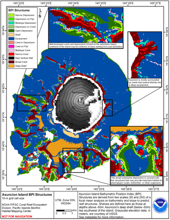 BPI Structures are derived from two scales of a focal mean
analysis on bathymetry and slope. The grid is based on
gridded (10 m cell size) multibeam bathymetry collected aboard NOAA
Ship Hi'ialakai and R/V AHI, and it was created using the Benthic
Terrain...
BPI Structures are derived from two scales of a focal mean
analysis on bathymetry and slope. The grid is based on
gridded (10 m cell size) multibeam bathymetry collected aboard NOAA
Ship Hi'ialakai and R/V AHI, and it was created using the Benthic
Terrain...