Scleractinian Coral Cover Maps Derived from Classified in situ Seafloor Imagery for Select U.S. Locations in the Pacific from 2001 to 2015
Coral cover maps depict percentage of scleractinian (hard) coral cover along survey tracks, overlain on existing bathymetric grids and/or satellite images, for islands and banks across the U.S. Pacific Islands Region. The coral cover data is derived from ...
Benthic Images from Towed-Diver Surveys in the Main Hawaiian Islands to Assess the Mass Coral Bleaching Event in November 2015
A team from the Pacific Islands Fisheries Science Center (PIFSC), Coral Reef Ecosystem Program (CREP) deployed on a two-week research cruise in November 2015 to evaluate the impacts of the 2015 mass coral bleaching event in the Main Hawaiian Islands via t...
CRED Optical Validation Data at the islands of Ofu and Olosega in American Samoa, 2002 to Support Benthic
Habitat Mapping (TOAD)
Optical validation data were collected using a Tethered Optical Assessment Device (TOAD), an underwater sled
equipped with an underwater digital video camera and lights. Data were collected at Ofu and Olosega, American Samoa to
support Benthic Habitat Map...
CRED Optical Validation Data at Palmyra Atoll in the Pacific Remote Islands Area (PRIA), 2002
to support Benthic Habitat Mapping
Optical validation data were collected using a Tethered Optical Assessment Device (TOAD), an underwater sled
equipped with an underwater digital video camera and lights. Data were collected at Palmyra Atoll to support Benthic
Habitat Mapping efforts durin...
CRED Optical Validation Data at Baker Island in the Pacific Remote Islands Area (PRIA), 2002, to Support Benthic Habitat Mapping
Optical validation data were collected using a Tethered Optical Assessment Device (TOAD), an underwater
sled equipped with an underwater digital video camera and lights. Data were collected at Baker Island to support
Benthic Habitat Mapping efforts during...
Dominant Benthic Structure and Biological Cover Habitat Maps for West Maui and West Hawaii
Benthic habitat maps depict dominant substrate type and biological cover in depths between 0 and ~150 m for two priority sites in the Main Hawaiian Islands; the NOAA Habitat Blueprint West Hawaii Focus Area (WHFA) and the Hawaii Division of Aquatic Resour...
CRED Optical Validation Data at Howland Island in the Pacific Remote Islands Area (PRIA), 2002, to Support Benthic Habitat Mapping
Optical validation data were collected using a Tethered Optical Assessment Device (TOAD), an underwater
sled equipped with an underwater digital video camera and lights. Data were collected at Howland Island to support
Benthic Habitat Mapping efforts duri...
CRED Optical Validation Data at the island of Ta'u in American Samoa, 2006 to support Benthic Habitat Mapping (TOAD)
Optical validation data were collected using a Tethered Optical Assessment Device (TOAD), an underwater sled
equipped with an underwater digital video camera and lights. Data were collected in American Samoa, around the island
of Ta'u to support Benthic ...
CRED Optical Validation Data at the island of Ofu and Olosega in American Samoa, 2006 to support Benthic Habitat Mapping (TOAD)
Optical validation data were collected using a Tethered Optical Assessment Device (TOAD), an underwater
sled equipped with an underwater digital video camera and lights. Data were collected in American Samoa, around
the islands of Ofu and Olosega to supp...
 Scleractinian Coral Cover Maps Derived from Classified in situ Seafloor Imagery for Select U.S. Locations in the Pacific from 2001 to 2015
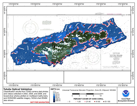 This map displays optical validation observation locations and percent coverage of hard coral overlaid on bathymetry.
 CRED Optical Validation Data at the islands of Ofu and Olosega in American Samoa, 2002 to Support Benthic
Habitat Mapping (TOAD)
CRED Optical Validation Data at the islands of Ofu and Olosega in American Samoa, 2002 to Support Benthic
Habitat Mapping (TOAD)
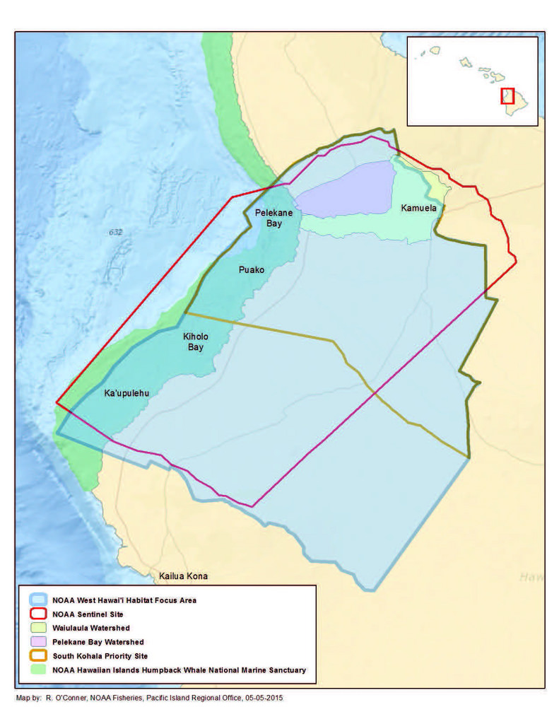 Benthic habitat maps depict dominant substrate type and biological cover in depths between 0 and ~150 m for two priority sites in the Main Hawaiian Islands; the NOAA Habitat Blueprint West Hawaii Focus Area (WHFA) and the Hawaii Division of Aquatic Resour...