 Rugosity Grid Derived from Gridded Bathymetry for Select U.S. Coral Reef Locations across the Pacific Ocean
Rugosity is derived for islands and banks across the U.S. Pacific Islands Region primarily from gridded multibeam bathymetry collected aboard NOAA Ships Hi'ialakai and Oscar Elton Sette, and aboard R/V AHI (Acoustic Habitat Investigator) from 2003 to 2012...
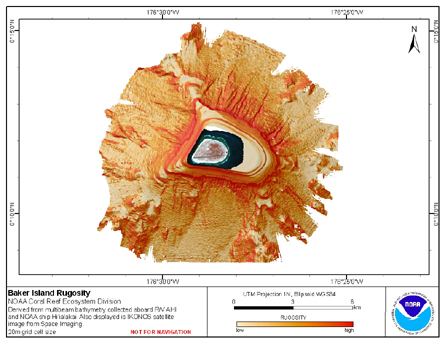 Rugosity is derived from gridded (20 m cell size) multibeam
bathymetry, collected aboard R/V AHI and NOAA ship Hi'ialakai.
Cell values reflect the (surface area) / (planimetric area)
ratio for the area contained within that cell's boundaries. They
provid...
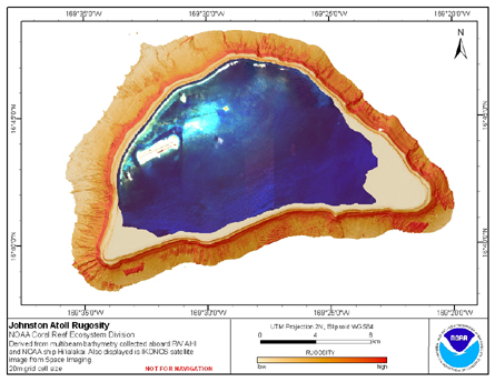
Rugosity is derived from gridded (20 m cell size) multibeam
bathymetry, collected aboard R/V AHI and NOAA ship Hi'ialakai.
Cell values reflect the (surface area) / (planimetric area)
ratio for the area contained within that cell's boundaries. They
provid...
 Rugosity is derived from gridded (20 m cell size) multibeam
bathymetry, collected aboard R/V AHI and NOAA ship Hi'ialakai.
Cell values reflect the (surface area) / (planimetric area)
ratio for the area contained within that cell's boundaries. They
provid...
Rugosity is derived from gridded (20 m cell size) multibeam
bathymetry, collected aboard R/V AHI and NOAA ship Hi'ialakai.
Cell values reflect the (surface area) / (planimetric area)
ratio for the area contained within that cell's boundaries. They
provid...
 Rugosity is derived from gridded (40 m cell size) multibeam
bathymetry, collected aboard R/V AHI and NOAA ship Hi'ialakai.
Cell values reflect the (surface area) / (planimetric area)
ratio for the area contained within that cell's boundaries. They
provid...
Rugosity is derived from gridded (40 m cell size) multibeam
bathymetry, collected aboard R/V AHI and NOAA ship Hi'ialakai.
Cell values reflect the (surface area) / (planimetric area)
ratio for the area contained within that cell's boundaries. They
provid...
 Rugosity is derived from gridded (5 m cell size) bathymetry from two sources:
Multibeam bathymetry collected by Coral Reef Ecosystem Division aboard NOAA R/V AHI, and
NOAA Ship Hi'ialakai; multibeam bathymetry collected aboard the US Naval Ship Sumner by ...
Rugosity is derived from gridded (5 m cell size) bathymetry from two sources:
Multibeam bathymetry collected by Coral Reef Ecosystem Division aboard NOAA R/V AHI, and
NOAA Ship Hi'ialakai; multibeam bathymetry collected aboard the US Naval Ship Sumner by ...
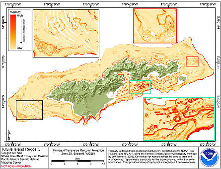 Rugosity is derived from gridded (5 m cell size) multibeam
bathymetry, collected aboard NOAA Ship Hiialaka'i and R/V AHI,
using the Benthic Terrain Modeler with rugosity methods by Jeff
Jenness (2003). Cell values reflect the surface area and
(surface are...
Rugosity is derived from gridded (5 m cell size) multibeam
bathymetry, collected aboard NOAA Ship Hiialaka'i and R/V AHI,
using the Benthic Terrain Modeler with rugosity methods by Jeff
Jenness (2003). Cell values reflect the surface area and
(surface are...
 Rugosity is derived from gridded (5 m cell size)
multibeam bathymetry, collected aboard R/V AHI, and bathymetry
derived from multispectral IKONOS satellite imagery using the
Benthic Terrain Modeler with rugosity methods by Jeff Jenness (2003).
Cell values...
Rugosity is derived from gridded (5 m cell size)
multibeam bathymetry, collected aboard R/V AHI, and bathymetry
derived from multispectral IKONOS satellite imagery using the
Benthic Terrain Modeler with rugosity methods by Jeff Jenness (2003).
Cell values...
 Rugosity is derived from gridded (5 m cell size)
multibeam bathymetry, collected aboard NOAA ship Hi'ialakai and R/V AHI using the
Benthic Terrain Modeler with rugosity methods by Jeff Jenness (2003).
Cell values reflect the (surface area) / (planimetric ...
Rugosity is derived from gridded (5 m cell size)
multibeam bathymetry, collected aboard NOAA ship Hi'ialakai and R/V AHI using the
Benthic Terrain Modeler with rugosity methods by Jeff Jenness (2003).
Cell values reflect the (surface area) / (planimetric ...
 Rugosity is derived from gridded (10 m cell size)
multibeam bathymetry, collected aboard NOAA ship Hi'ialakai and R/V AHI using the
Benthic Terrain Modeler with rugosity methods by Jeff Jenness (2003).
Cell values reflect the (surface area) / (planimetric...
Rugosity is derived from gridded (10 m cell size)
multibeam bathymetry, collected aboard NOAA ship Hi'ialakai and R/V AHI using the
Benthic Terrain Modeler with rugosity methods by Jeff Jenness (2003).
Cell values reflect the (surface area) / (planimetric...
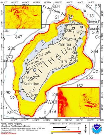
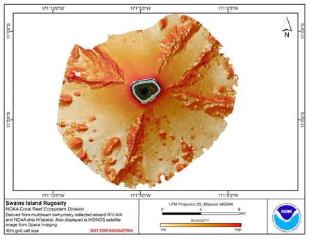 Rugosity is derived from gridded (40 m cell size) multibeam
bathymetry, collected aboard R/V AHI and NOAA ship Hi'ialakai.
Cell values reflect the (surface area) / (planimetric area)
ratio for the area contained within that cell's boundaries. They
provid...
Rugosity is derived from gridded (40 m cell size) multibeam
bathymetry, collected aboard R/V AHI and NOAA ship Hi'ialakai.
Cell values reflect the (surface area) / (planimetric area)
ratio for the area contained within that cell's boundaries. They
provid...