 Slope Grid Derived from Gridded Bathymetry for Select U.S. Coral Reef Locations across the Pacific Ocean
Slope is derived for islands and banks across the U.S. Pacific Islands Region primarily from gridded multibeam bathymetry collected aboard NOAA Ships Hi'ialakai and Oscar Elton Sette, and aboard R/V AHI (Acoustic Habitat Investigator) from 2003 to 2012 by...
 Slope is derived from gridded (20 m cell size) multibeam
bathymetry, collected aboard R/V AHI, and NOAA ship Hi'ialakai.
Cell values reflect the maximum rate of change (in degrees) in
elevation between neighboring cells derived with the ArcGIS
Spatial Ana...
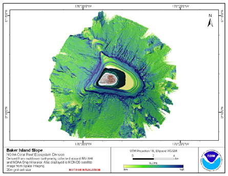
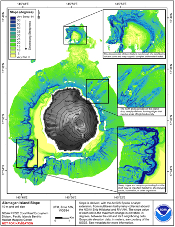
Slope is derived from gridded (20 m cell size) multibeam
bathymetry, collected aboard R/V AHI, and NOAA ship Hi'ialakai.
Cell values reflect the maximum rate of change (in degrees) in
elevation between neighboring cells derived with the ArcGIS
Spatial Ana...
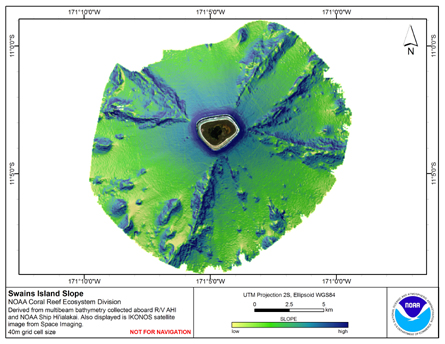
 Slope is derived from gridded (40 m cell size) multibeam
bathymetry, collected aboard R/V AHI, and NOAA ship Hi'ialakai.
Cell values reflect the maximum rate of change (in degrees) in
elevation between neighboring cells derived with the ArcGIS
Spatial Ana...
Slope is derived from gridded (40 m cell size) multibeam
bathymetry, collected aboard R/V AHI, and NOAA ship Hi'ialakai.
Cell values reflect the maximum rate of change (in degrees) in
elevation between neighboring cells derived with the ArcGIS
Spatial Ana...
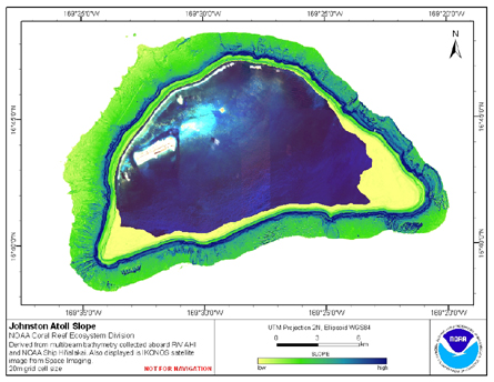 Slope is derived from gridded (20 m cell size) multibeam
bathymetry, collected aboard R/V AHI, and NOAA ship Hi'ialakai.
Cell values reflect the maximum rate of change (in degrees) in
elevation between neighboring cells derived with the ArcGIS
Spatial Ana...
Slope is derived from gridded (20 m cell size) multibeam
bathymetry, collected aboard R/V AHI, and NOAA ship Hi'ialakai.
Cell values reflect the maximum rate of change (in degrees) in
elevation between neighboring cells derived with the ArcGIS
Spatial Ana...
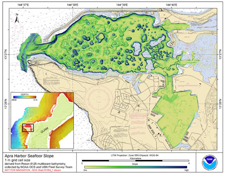 Slope is derived from gridded (1 m cell size) multibeam
bathymetry, collected aboard the Survey Vessel Swamp Fox. Cell
values reflect the maximum rate of change (in degrees) in elevation
between neighboring cells derived with the ArcGIS Spatial Analyst
ex...
Slope is derived from gridded (1 m cell size) multibeam
bathymetry, collected aboard the Survey Vessel Swamp Fox. Cell
values reflect the maximum rate of change (in degrees) in elevation
between neighboring cells derived with the ArcGIS Spatial Analyst
ex...
 Slope is derived from gridded (10 m cell size) multibeam
bathymetry, collected aboard NOAA Ship Hiialaka'i and R/V AHI.
Cell values reflect the maximum rate of change (in degrees) in
elevation between neighboring cells derived with the ArcGIS
Spatial Anal...
Slope is derived from gridded (10 m cell size) multibeam
bathymetry, collected aboard NOAA Ship Hiialaka'i and R/V AHI.
Cell values reflect the maximum rate of change (in degrees) in
elevation between neighboring cells derived with the ArcGIS
Spatial Anal...